Showing posts with label Roads. Show all posts

Saturday, May 23, 2020

A new road between Tibet and Xinjiang

G216 cutting across the Taklamakan Desert
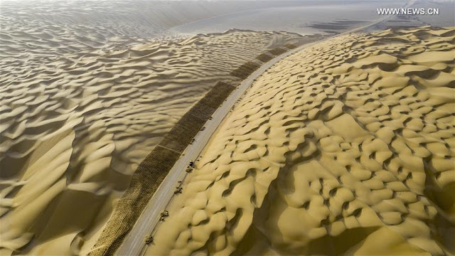
On May 16, 2020, impressive pictures of workers driving bulldozers on a construction site in the Taklamakan Desert were released by Xinhua.
The caption explained: “The construction of Yuli-Qiemo highway, the third north-south route running through Taklamakan Desert, has entered the final rush. Workers of China Communications Construction Company Ltd are working on the largest dune in this project, with an estimated volume of 1.2 million cubic meters of sand to deal with.”

The Yuli-Qiemo highway is a section of the National Highway 216 (known as G216) linking northern Xinjiang to Kyirong county in Tibet (the border town with Nepal). A few years ago, I had mentioned the possibility of having a second road link between the two restive provinces of Tibet and Xinjiang (the first one is the G219 or Aksai Chin road, running through the Indian territory).

Xinhua’s caption continued: “They established camps next to the dune for the convenience of work, and receive daily necessities on a regular basis. The completion of the highway is expected to improve the transport conditions in southern Xinjiang and promote local development.”

For obvious reasons, Beijing does not want to announce as yet that they are building this new highly strategic link, which will serve the under-developed parts of Gerze county of Western Tibet (Ngari Korsum) ...and reached Nepal. It is probably an important part of the Belt & Road Initiative  between Central and South Asia, dreamt by Xi Jinping.

But this is not the trickiest part of the project.
How will the Chinese engineers managed to cross the Kunlun range and reach Rutok county?
Once on the plateau, the terrain (probably via Gerze county) will be easier.
Today many still believe that it is impossible to cross the Kunlun.
But Beijing has probably done its home work and studied the 19th century Western explorers such as Sven Hedin or Aurel Stein who moved around the area and found slightly-easier passages to cut across the formidable natural barrier.
It is interesting to see if this new road link will be included in the next Five-Year Plan (2021-2025).

Some twenty pictures show workers on the lunar ‘dune’ landscape around the future highway crossing the Taklamakan Desert.


Here is a tentative route to be followed by the G216.

Incidentally, on May 14, the Xinjiang Production and Construction Corps (XPCC)  announced that it will pump a lot of funds into transportation projects during the current year.
According to Xinhua: "The [Xinjiang] authorities will invest 9.5 billion yuan (about 1.34 billion U.S. dollars) in 60 major road projects, with plans to build or upgrade roads with a combined length of 2,281 km, according to the local transportation bureau. Of the investment, the Xinjiang Production and Construction Corps will allocate 5.7 billion yuan to its areas of jurisdiction in the southern part of Xinjiang."
It was said that the XPCC has already resumed work on a number of major transportation projects.
It is ominous for the Ladakh border, where the Chinese have started creating serious problems on the Indian side of the LAC, for example in Galwan area and north of the Panggong tso.

Another Section of G216
On May 20, Xinhua published a series of photos showing the construction site of Tianshan Shengli tunnel, a six-year project on the Urumqi-Yuli highway. The news agency says: "it passes through a cold and high altitude zone, with harsh climate and geological condition." This is apparently part of the same G216 Highway project.


Yet another Infrastructure Project in Xinjiang
Tracklaying has started on the Ruoqiang–Hotan railway project south of the Taklamakan Desert.
According to Construction Review Online: “Running east from the current rail-head at Hotan south of Kashgar to Qiemo and then northeast to Ruoqiang, the 825 km line will have 65 stations, serving a string of small towns between the Tarim Basin and the Altun Shan mountain range. It will connect at Ruoqiang with the 1214 km Golmud–Korla line now nearing completion.”
The portal provides further details: “Designed for operation at up to 120 km/h, the single track line was authorised by the National Development and Reform Commission in May 2018. Construction was formally started on December 20 that year, and completion is expected by mid-2022. Capacity is being provided for up to eight daily passenger trains each way and around 15 million tonnes of freight per year. Total cost of the project is put at US 3.1 bn, of which the national government is contributing 54.2%, Xinjiang Uyghur Autonomous Region 23.3% and China Railway 22.5%. This budget includes 790m yuan for rolling stock.”
The Project Manager Zhang Gang of China Railway 14th Bureau Group said that a management and construction team with ‘rich experience in desert railway construction’ to work in the ‘intricate natural environment’ has been working on the project: “the construction teams will be ‘working around the clock’ to lay an average of at least 2km per day. The target is to complete 520km of track and 19 stations by the end of this year.”
China is in a hurry; India should realize this.

Here is my old posting dated 2016:

 The Changthang or ‘Northern plain’ (in Tibetan), occupies a large part of the Tibetan plateau.
In April 2000, with the approval of the State Council, the Changthang National Nature Reserve, located in northern Tibet, south of the Kunlun Mountains, became a national reserve.
It spreads on a total area of 391,200km, which makes it the second largest nature reserve in the world, after the Northeast Greenland National Park.
With the recently-established adjoining reserves, there is now a total of 496,000 km2 of connected Nature Reserves.
The Changthang National Nature Reserve lies at an average elevation of 4,500 meters. Administratively, it comes under the Prefectures of Nagchu and Ngari. Some parts of the Reserve are located in the County of Rutok, bordering Ladakh and the Aksai Chin.
Only a few Tibetan nomads permanently live there, but it is a paradise for wild animals such as wild yak (Bos grunniens), Tibetan wild ass or kiang (Equus kiang), Himalayan blue sheep or Bharal (Pseudois nayaur), Argali (Ovis ammon), Mongolian gazelle (Procapra gutturosa) and Tibetan antelope or chiru (Pantholops hodgsonii). The list of predators is also long; it includes snow leopards (Panthera uncia or Uncia uncia), Tibetan wolves (Canis lupus chanco), Turkestan lynx (Lynx lynx isabellinus) and Tibetan blue bears (Ursus arctos pruinosus).

Road will cut through the eastern part of the Reserve
An Environmental Impact Assessment
Recently, a “Public Announcement for the Environmental Impact Assessment [EIA] of the New Reconstruction Project of National Highway No. 216 (Tibet Area)” was made from Ngari Prefecture in Western Tibet.
According to published abstracts of the EIA: "The State Environmental Protection Bureau of the National Highway 216 (Tibet area) area has basically completed the project environmental impact, for pollution prevention and control.”
(National Highway 216 (G216) runs in the Xinjiang Uyghur Autonomous Region in the southern direction from Altay City to Baluntai in Hejing County, where it joins China National Highway 218. It is 857 kilometres in length). 
The EIA says: “Control measures analysis and evaluation have been completed in accordance with the relevant provisions of the Interim Measures for Public Participation in Environmental Impact Assessment”.
Some ‘relevant’ contents of the EIA have even been made public, probably a first in China.

Here some extracts of the Chinese documents (please excuse inexactitudes; it is a translation through Google language).

I.    Overview of construction projects

The Overview provides an idea of the route followed by the new highway starting from Xinjiang (near Dunhuang? Crescent Lake?) and joining the G 219 (the Aksai Chin road) in the Rutok County.
The Highway will be connecting Xinjiang and Tibet via Minfeng, it should ultimately connect with the Highway G 216 in Xinjiang.
The project is 558 km long.
The deeply-worrying aspect of the project is that it crosses the highly eco-sensitive Changthang National Nature Reserve.
It will run for 110 km in the main reserve, about 270 km in the buffer zone and some 100 km in the ‘experimental area’.
The starting point of this project is the Jieze Lake near the G 219 highway (north of Rutok).
According to the EIA, the road will be built “in accordance with the two-lane highway construction.”
The total investment for the project is RMB 6.453 billion (more than 1 billion US dollars). The construction should start by the end of the current year and the road will be put into operation early 2021. The construction period has been estimated at 48 months.
The main environmental impact assessment says:

1- During the construction period
  1. Noise: The main noise sources during the construction period will be the mechanical bulldozers, the loaders, the excavators and other construction equipment and transportation vehicles. Construction units will carry out the construction work in accordance with the relevant laws and regulations of the State (China) and the Tibet Autonomous Region.
  2. It will be characterized by “a reasonable layout of the construction site; reasonable arrangements for operating time of the work; scientific management and civilized construction [sic]”.
  3. Exhaust gas: Strict implementation of the relevant provisions of the State and the Tibet Autonomous Region will be followed.
  4. Dust: Measures will be taken to minimize the dust: the earth mixer/cement mixer will be closed; the area will be sprinkled; the site will be regularly cleaned; the asphalt mixing station will used ‘good sealing’ materials; high efficiency dust mixing equipment will be used to create the less possible impact on the atmospheric environment.
  5. Wastewater: Construction camps will prevent the seepage of the domestic sewage. After use, the wastewater will go through a sedimentation treatment plant; dust suppression will be taken care of.
  6. Solid wastes: All excavated soils produced by the project shall be reused or transported in closed vehicles. Offloading shall be prohibited to prevent spillage. Earthworks dumps shall be selected according to relevant requirements and measures shall be taken to prevent soil erosion.
  7. Ecological: The construction should be strictly in accordance with the provisions of the approved design. The construction should remain within the scope of plans and it shall not be allowed to expand. At the same time [at the end of the project?] a project evaluation shall seriously be implemented and an assessment made of biological and ecological diversity according with the environment protection laws. At the end of the construction period, timely measures will be taken to reclaim the land (of the construction site).
2 -After the construction period
  1. Environmental noise: Near the sensitive points, speed will be limited and other measures to reduce traffic noise will be taken. Appropriate measures will be taken for the traffic noise in the sensitive areas. The future planning of both sides of the open space should be based on the results of noise assessment.
  2. Ambient air: The air pollution will come mainly from automobile exhausts; the vehicle control, particularly of the automobile exhaust, will be strengthened.
  3. Water environment: During the operation period, the domestic sewage generated from the maintenance area will be treated by anti-seepage aqua plants. Bridge across the river will set up runoff collection systems at both ends of the bridge using sedimentation tanks.
3 - The preliminary conclusions of the EIA report are:
The proposed project is in line with the National Highway Network Plan (2013-2030). The route selection takes full account of the economic, environmental and technical feasibility principles.
It is line with the strict implementation of the ‘three simultaneous’ system, respectively, for the ecological environment, water environment, atmospheric environment.
It takes effective protection measures, will effectively control the adverse environmental impact of roads, along the area to promote economic and social development [of the area]
The project is considered to be viable from the perspective of environmental protection under the premise of obtaining the forest assessment and the biodiversity evaluation report and obtaining the approval of the related project of forestry department.

4 - Seek public views on the main issues
In order to listen to the views and suggestions of the community on the environmental protection work of the national highway 216 (Tibet border) and the 'rebuilt' section of the highway, the project will be publicized to solicit the public's valuable opinions and suggestions.
The main issues include: whether you are aware of the construction of this project; after the completion of the project, your views on the surrounding environment and the impact on your working life; your views and suggestions on environmental protection work.

5 - The public views 
During the ‘publicity period’ for the environmental impact assessment of the project, the public can contact the Construction Unit and the EIA unit.
The public may contact the project construction unit or the EIA unit by way of letter, telephone, e-mail, etc. to obtain supplementary information or to express opinions and opinions on the project construction and EIA work.

The environmental impact assessment unit will record the opinions and suggestions of the public in the environmental impact report of the project and forward the public's valuable opinions and suggestions to the construction unit and the relevant departments of the Government.

Construction Unit:
Key Project Management Center of Transportation Bureau of Ngari District, Tibet Autonomous Region

Evaluation unit:
Beijing Yan State Environmental Technology Development Co., Ltd located in Beijing

Implications for India
This of course does not deal with the strategic implications of the new road which should shorten the time to travel from Urumqi to Rutok (near the Indian border).

Friday, November 10, 2017

Why all this fuss for a few Indian tunnels?

Rongme Ngatra Tunnel, stretching 13 kms on National Highway No 317
The meaning of ‘double standards’ is unknown in China.
After The Economic Times reported that India plans to construct 17 highway tunnels totaling 100 kilometers along the line of actual control, The Global Times bitterly complained.
The Party mouthpiece quoted Xie Chao, an ‘expert’ at Tsinghua University's Department of International Relations, who said that: “boosting border infrastructure has been Indian's consistent policy.”
A poor joke, when one knows the reality.
Another ‘expert’, Zhao Gancheng, director of the Center for Asia-Pacific Studies at the Shanghai Institute for International Studies stated that "the tunnel building along the border is a further fermentation after the Doklam standoff."
He reiterated China’s baloney stand: “One June 18, Indian troops illegally crossed the border and trespassed into Chinese territory in Doklam.”
Fermentation or not, India is far behind China in the field of infrastructure.
Zhao dared to tell The Global Times: “Although some Indian senior officials made a friendly gesture toward China after the standoff, India has pursued its previous policy along the border - developing infrastructure as well as troop mobility.”
The Global Times commented; “The Indian government is playing two cards over the border issue, the situation of which will be a ‘new normal’ for the China-India border.”
Xie Chao warned: "It is the Chinese government's responsibility to safeguard border safety and China won't take the initiative to seek military force to tackle border problems. But a balanced force along the border will make China cope with the tensions."
Is it not ‘double standards’?
While India is 20 or 30 years behind China is terms of development of border infrastructure, the slightest improvement on the Indian side is shown by Beijing and its ‘experts’ as an aggressive move.

Infrastructure on the Tibetan side
Just read the Chinese press, you will understand.
On October 28, China Tibet News announced that the newly-built runway of Chamdo Bangda Airport was officially put into use, “ushering in a new period of rapid growth.”
A total of 19,000 flights took off or landed at Bangda Airport; it boasts of 1.876 million passenger throughput. The new runaway will improve further the traffic: “In 2015, with a total investment of 849 million yuan [150 million US dollars], the airfield renovation project was started and it was built on 4C standard,” said the website.
Chamdo Bangda Airport has already flights to Lhasa, Chengdu, and Chongqing; soon planes will be able to fly to Tianjin, Fujian, and other Mainland cities.
At the same time, the reconstruction project of the highway from Shigatse Peace Airport to Shigatse City has begun, Shigatse will become “a comprehensive transportation hub”.
It will be an important part “for Tibet's export-oriented economic development,” said the website. Practically it will be a next stage towards opening a road and railway to Nepal.
According to China Tibet News: “After this project is completed, it will improve the regional traffic conditions and play a key role in meeting Tibet's high grade highway demand.”

On October 23, another website, China Tibet Online affirmed: “China's central government continues to increase support for infrastructure construction in southwest China's Tibet and Tibetan-inhabited areas in Qinghai, Gansu, Sichuan and Yunnan Province, striving to break the bottleneck that constraints the social development and people's livelihood improvement in those regions.”
According to the Chinese website: “Since 2012, Tibet has opened the Lhasa-Shigatse Railway, and the Lhasa-Nyingchi Railway also enters its construction, starting a new era in railway construction. Highway distance increased from 62,500 kilometers in 2012 to 82,100 kilometers in 2016, an increase of 25.9 percent. There are 71 domestic and international air routes connecting Tibet with 41 cities.”
And the list goes on.

Developments in Tibetan-inhabited areas
The fast-track infrastructure development is not limited to the Tibetan Autonomous Region; it extends to the Tibetans-inhabited provinces.
So why this fuss for a few Indian tunnels, which will take years to materialize?
In the power fields too, giant steps are taken on the plateau.
China Tibet Online provides details on the Sichuan-Tibet Power Interconnection Project which has recently been put into operation, “eliminating serious power shortages in Chamdo City in the Tibet and the southern part of the Garze Tibetan Autonomous Prefecture in southwest China's Sichuan Province. The total power installation capacity is 2.65 million kilowatts, 1.3 times more than that in 2012.”
It is said that it for the first time Tibet achieved net electric power transmission of 200 million kilowatts hour outwards.

More infrastructure in Sichuan
The same website further asserts that “Sichuan implemented two rounds of the ‘three-year transportation battle’, while completing and opening the Yading airport in the Daocheng County in Garze and the Hongyuan airport in Aba Tibetan and Qiang Autonomous Prefecture, construction on the Gesar Airport in Garze, the Chengdu-Lanzhou Railway, the Chengdu-Ya'an part of the Sichuan-Tibet Railway and the Ya'an-Kangding as well as Wenchuan-Markham Highways have also begun. At the end of 2016, the total distance of the highway in Tibetan-inhabited areas in Sichuan reached 45,200 kilometers.”
Does India complain each time, China open a dual-use airport on the plateau?

In Yunnan too
At the same time, in Yunan Province, “1,142 projects have been completed of the 1,344 major projects implemented over the last five years, and a total of 103.9 billion yuan (15.7 billion US dollars) have been invested.” While Gansu Province opened in 2013 the Xiahe Airport and the Linxia-Hezuo Highway, respectively the first civil aviation airport and the first highway in its Tibetan-habited areas, the first railway line, from Lanzhou to Hezuo, has also been under construction in 2016. There are currently 10,046 kilometers of highway, and 95 percent of villages are accessible to modern transportation in the Tibetan-inhabited areas.”
The highway coverage in Tibetan-inhabited areas of Qinghai Province reached 65,117 kilometers in 2016, increasing by 11,367 compared with 2012. The 251 townships and 1,659 villages in its Tibetan-inhabited areas are all accessible to highways.
This is not called ‘double standards’ when so-called experts complained after India struggling to provide genuine communication facilities for the border population in the Himalaya.

In the meantime, a combined army brigade under the PLA's 77th Group Army (former 13th Group Army) practiced at an altitude of 4,700 meters on the plateau area on November 7, 2017.
India is not making a fuss.


Friday, February 24, 2017

A Train to Chumbi Valley?

A Tibetan website has just announced that the Mila (spelt ‘Mira' by the Chinese media) tunnel will be opened on June 30.
According to Tibetonline.cn, at an average altitude of 4,740 meters, this will become the world's highest highway tunnel. It will eventually cut the journey between Lhasa and Nyingchi (or Nyingtri) by some four hours.
The website says: “The tunnel has a longer-than-average length with 5,727 meters on the left and 5,720 meters on the right.”
The Mila Mountain lies at the border between the Lhasa Municipality (Meldro Gungkar County or Mozhugongka Xian in Chinese) and the Nyingchi Prefecture (Kongpo Gyamda County).
Located at an elevation of 5013 meters above the sea level, it is the highest point on the Nyingchi–Lhasa highway, a section of National Highway 318 (the 5400-km road between Shanghai and Zhangmu at the Tibet-Nepal border).
The plan to build a tunnel on this section of the road was announced in January 2015. Construction started just after.
Tibetonline.cn adds: “Affected by the high altitude, the tunnel project encountered many difficulties during the construction process. Rocks surrounding the tunnel's exit are very loose, and it is very cold in the tunnel with considerably thin oxygen. The minimum temperature in winter reaches minus 30 degrees Celsius.”
Wang Liang, chief engineer of the project affirmed that the travel time between Lhasa and Nyingchi will be reduced from eight hours to three or four hours, after completion of the project.
Can you believe it? Quite a feat.
Wikipedia described the area thus: “The west of the mountain is dry and cool, while the east side is warmer and has more moisture, and therefore has richer vegetation. The foothills have natural pastures and farmland. Trees include Yunnan pine birch and fir. Wildlife includes roe deer, antelope and bear.”

More and more tourists on the plateau
A few days back, Kangba TV reported that “over 23 million domestic and foreign tourists visited Tibet Autonomous Region (TAR) in 2016, up by 14.8%, creating a tourism revenue of 33.075 billion yuan, up by 17.3%.”
Whether the figures are accurate or not, it is certain that Tibet is very popular with the Chinese holiday-goers.
The government in Lhasa also announced that in 2017, it will give “priority to building 4 national region-based tourism demonstration areas, including Lhasa City, Nyingchi City, Shigatse City and Purang County in Ngari area as well as 4 TAR-level region-based tourism demonstration areas, including Chengguan and Tohlung Dechen districts in Lhasa, Kongpo Gyamda County in Nyingchi and Pome County.”
It has to be noted that Purang is near the trijunction between India, Tibet and Nepal. The Kailash Yatra via Lipulekh-la passes via Purang (also known as Taklakot).
There is no doubt that Ngari will be the next area to be developed on a grand scale for tourism.
Lhasa also said that in 2017 the TAR plans to receive at least 25 million tourists, providing 380,000 people with jobs in the tourism sector.
But jobs for whom?
For Han migrants or local Tibetans?
It is obviously not mentioned by the authorities in Lhasa.

Tibetan Culture and Infrastructure
Interestingly, Communist China has recently discovered Tibetan culture.
The Chinese embassy in Kathmandu even hosted a special function for celebrating Losar, the ‘Chinese Tibetan Losar’ (sic).
Chinese Ambassador Yu Hong said that Losar is the most ‘ceremonious’ traditional festival of Tibetan people; she extended her “sincere wishes and greetings to all the Tibetan compatriots living in Nepal, and pay tribute to all the friends for your care and support for the development of Tibet."
Interestingly Madam Yu spoke of the railway connectivity between Nepal and China and noted that a train recently operated between Guangdong province, Tibet and Middle-South Asia; it started from Guangzhou, went to Lhasa, Kerung [Kyirong] to Kathmandu, covering a total length of 6,070 km and becoming the first highway-railway combined transport channel linking Guangdong, Tibet and Nepal.
She told the Tibetan 'community' in Kathmandu: "Our fellow Tibetan compatriots, despite living in a foreign land, always concerned about the progress and development of the motherland, and have made contribution to national unity and ethnic solidarity.”.
Another website VTIBET.com quoted figures from the TAR’s Development and Reform Commission: “Data show that Tibet speeds up and strengthens quality of traffic construction.”
It says that the TAR has spared “no efforts to solve the bottleneck problems restricting the development of traffic infrastructure.”
In 2016, the total distance of road opened to traffic in Tibet reached the staggering figure of 82,500 kilometers; the website also mentions the work on the Sichuan-Tibet Railway and the Yunnan-Tibet Railway undertaken during the 13th Five-Year Plan: “the Civil Aviation opened 71 air routes of domestic and international with 41 navigable cities, significantly increasing comprehensive transport capacity. The fixed-asset investment of Tibet's communication and transportation accumulatively achieved 40.21 billion yuan."
In 2016, China started to build 44 key highway projects.
It also asserts: “Tibet's railway construction projects invested about 8.5 billion yuan in 2016, of which the work of Nyingchi-Kangting section of Sichuan-Tibet Railway [in fact probably the Chengdu-Ya’an section of the line], Lhasa-Meldro Gungkar Railway [part of the Lhasa-Nyingchi line], Shigatse-Gillon [Kyirong at the Nepal border] Railway, Bomda [Pome]-Shangri-la section of Yunnan-Tibet Railway, and the earlier stage of Shigatse-Yadong [Yatung] Railway is proceeding orderly.”
It means that the project to take the train to the Indian border near Sikkim (in the Chumbi Valley) is still on, though at its ‘early stages’.
The website continues: “For Civil Aviation's part, Tibet has 5 navigable airports, 9 aviation companies operating in Tibet. It safeguarded 39,000 sorties of take-off and landing flight last year, received 4.05 million of the annual passenger and 30,000 tons of cargos and parcels.”
The shortening to the journey between Lhasa and Nyingchi, the new railway lines to Yatung and Kyirong have serious strategic implications for India.
Why is the Indian press keeping silent about this?
The answer is that many in India believe that if China dares to cross the McMahon line and walk down in Arunachal, it will 'break its teeth' in the Indian roads.
It is not 100% sure.
 
Chegdu-Ya'an railway line
 

Tuesday, January 17, 2017

The integration of military and civilian development


I recently mentioned the new roads being built in Western Tibet (Ngari) towards the Indian border (G564 and G565).
But that is not all.
According to Kangba TV, the Tibet Autonomous Region (TAR) has created a basic integrated transport network, with a total road mileage of 82,500 km, five airports, 71 domestic and international airlines, as well as the Qinghai-Tibet and Lhasa-Shigatse railway lines.
During a press conference, Sonam Chophel, director of the TAR transport department asserted: “Transport is the key role in economic development. Therefore, in order to break the bottleneck of economic development, we need to have good transport.”
Sonam Chopel also said, “In 2016, TAR has attracted a total investment and bank loan of 54.6 billion yuan [for infrastructure]. 44 key road projects are under construction.”
The TAR has spent 8.5 billion yuan in railway projects in 2016, and 7.5 billion yuan were used on the Tibet section Sichuan-Tibet Railway.
With the arrival of Che Dralha at the helm of the TAR government, this trend will probably accelerate, as one of his objectives is to develop tourism on a large scale.
China Tibet Online further announced that “the highest ring road is being built”.
With six lanes, the road will circle around Lhasa city. It will have a total length of 100km; it will include seven tunnels and 27 overpasses.
Once the road is opened in June, the drive around the capital city will only take two hours.

Loyalty to the core

On January 11, Wu Yingjie, Secretary of the TAR Party Committee, met a delegation of senior officers of the People’s Armed Police on the side of the Regional People’s Congress.
Lt Gen Xu Yong, the Commander of the Tibet Military Region was in attendance.
It is said that the atmosphere is very warm.
Wu asked the officers to pledge “absolute loyalty to the party under the strong leadership of the Party Central Committee with Comrade Xi Jinping as the core, with the unselfish support of the people of the whole country.”
He urged the attendees to “consolidate the good situation of sustained harmony and stability, to maintain sound and rapid economic and social development and to achieve the objectives of the 13th Five-Year Plan.”
The Armed Forces have made outstanding contributions for the maintenance of the local stability, the economic development, the improvement the people's livelihood and the implementation poverty alleviation and national unity, he said.
He added that Tibet is located “in the southwest border of the motherland, in the first line of anti-separatist struggle; it is the main battlefield.”
This refers to the Tibetans living in India.
Wu insisted that he hoped that the PLA stationed troops will resolutely implement "the instructions of the Party Central Committee, the Central Military Commission and the President of the CPC while strengthening the army's objective under the new situation.”
He probably meant the in-depth reforms of the PLA.
Wu also repeated: “One must be absolutely loyal to the core. The central position of General Secretary Xi Jinping was established …to comprehensively promote reform, development, stability, internal affairs, foreign affairs, national defense and the rule of the Party.”


The integration of military and civilian development 
Perhaps more importantly for India’s borders, Wu asked the troops and officers to “promote the integration of military and civilian development.”
It has serious implications for the infrastructure on the plateau, particularly for the new roads leading to the Indian border.
Wu remarked: “Party committees and governments at all levels should inherit and carry forward the glorious tradition of unity between the military and the army and the people, and further consolidate the military-military-civilian relations between the army and the people.”
Note that the building of the above-mentioned ‘integrated infrastructure’ relates to both the military and the civilian.
For the Party boss of Tibet, it is necessary to “conscientiously implement the economic construction and national defense construction.”
He further mentioned “the implementation and the integration of these views on development”, while urging the officers “to adhere to military and civilian joint construction” and take the initiative "to integrate national defense and military construction into local economic and social development planning.”
India could perhaps learn for Tibet and China.

Monday, June 6, 2016

The Closure of the Indian Consulate in Kashgar and the Aksai Chin Road

Last week, I quoted an article published by Xinhua about the Aksai Chin Road (Xinjiang-Tibet Highway or NH 219 for China); it concluded: “The highway today looks to me like an airport runway -- wide, flat and smooth - a heavenly road, indeed.”
It is certainly a great boon for the People's Libration Army (PLA) and China’s border management in general.
Xinhua asserted: “With a safe, modern highway, transportation costs from Yecheng to Ngari have fallen by 55 percent, leading to cuts of about 40 percent in the price of commodities in the Tibetan town. Better yet, the number of tourists in Ngari has surged five-fold.”
It is probably just a beginning.
Ngari area (Western Tibet) is going to become a very fashionable tourist destination in the years to come.
It will have critical implications for India's borders.
To understand how this point was reached, I reproduce below an extract of my book, Born in Sin - the Panchsheel Agreement.
To close down the Indian Consulate in Kashgar, without getting anything in return, was probably one of Nehru's greatest blunders.
But, like other blunders, it has been forgotten long ago.


The Closure of the Kashgar Consulate
A series of incidents occurred in the early fifties should have awakened the Government of India from its soporific Hindi-Chini Bhai Bhai dream-like world. It was not to be so.
Instead of alarming Nehru, these disturbing reports reinforced his determination to bolster the friendship with China.
On September 1, 1953, Nehru began a letter to the Chinese Premier thus:
It has been a matter of deep satisfaction to me to note the growing cooperation between our great countries in international affairs. I am convinced that this cooperation and friendship will not only be to our mutual advantage, but will also be a strong pillar for peace in Asia and the world.
The first of these incidents was the harassment of the Indian Trade Agent posted in Gartok in Western Tibet. Though Nehru wrote to Zhou Enlai about it, no following action was taken and no proper analysis of Chinese motivations was made.  And the complain was weakly drafted!
Nehru barely brought the matter to Zhou’s notice:
Recently, some incidents have taken place when the local authorities in Tibet stopped our Trade Agent in Western Tibet from proceeding on his official tour to Rudok and his staff to Taklakot, both important trade marts for Indian traders and pilgrims. There has been a forcible seizure of his wireless set which is essential for the performance of his duties. We learnt of this incident with surprise and regret, because it did not seem to us in consonance with the friendly relations between our two countries.
The harassment of the Indian Trade Agent in Western Tibet was without doubt linked with the work which had started on the Tibet-Xinjiang highway.
Rudok, located midway between Lhasa and Kashgar is the last small town before entering the Aksai Chin.
The presence of an Indian official there was embarrassing for the Chinese as they had started building a road on Indian soil. Did Nehru see the implications of the incident or did he still believe in Chinese goodwill?
His letter concludes thus:
I would invite Your Excellency’s Government to confer with our Government at the earliest suitable opportunity, either in Delhi or in Peking, on all such matters affecting relations between our two countries.
An official Indian report mentions that S.S. Khera, a Cabinet Secretary in 1962, later wrote that “information about activities of the Chinese on the Indo-Tibetan border particularly in the Aksai Chin area had begun to come in by 1952 or earlier.”

India's interests gone with the wind 

If the Indian government had been ready to read beyond the Chinese rhetoric and Zhou’s assurance of friendship, it would have seen many more ominous signs. One of them was the closure of the Indian Consulate in Kashgar.
Here again, as in several other cases, Nehru justified the Chinese actions without taking any retaliatory measures or even protesting. India’s interests were lost to the ‘revolutionary changes’ happening in China. He declared in the Parliament:
Some major changes have taken place there [Kashgar]. As a result of those changes, which have nothing to do with India at the moment… our Consul went there – I speak from memory – probably in 1948, maybe even later, in 1949. But when these changes, revolutionary changes took place there, it is perfectly true that the Chinese Government, when they came to Tibet, told us that they intended that they wanted to treat Sinkiang as a closed area. They told other State Government, too. Well, nothing happened. Our Consul remained there. But because of those changes, because of many factors – among them being what happened in Kashmir – the trade ceased... Kashgar is important to us as a trade route. The trade went over the Karakoram, passed though Ladakh and Leh on to Kashmir. Various factors, including developments in Kashmir led to the stoppage of that trade... The result was, our Consul remained there for some time, till recently… but there is now no work to be done. So we advised him to come away and he did come away.
India had been trading with Central Asia and more particularly Kashgar and Yarkand for millennia.
Just because ‘revolutionary changes’ had occurred, the Government of India accepted the closure of its trade with Sinkiang as a fait accompli.
The reference to Kashmir is not relevant. Since the winter of 1948, India controlled the Zoji-la pass as well as Ladakh. At that time, the Karakoram Pass was still open to the caravans.
The unnecessary closure of the Indian Consulate in Kashgar was the green light that Mao needed to start building the Aksai Chin Road on the Indian territory.

Photos of the road today:


Wednesday, September 16, 2015

More Infrastructure on the Tibetan Plateau

According to the Tibet Business Daily, a ‘high-grade highway’ between Lhasa and Nyingchi (Tibetan, Nyingtri) is expected to begin its trial operations on September 15.
On September 10, 2015, local reporters drove from Lhasa to Meldro Gungkar (Maizhokunggar) County to ‘experience highway conditions’ on this section of the new Lhasa-Nyingchi highway.
Their ‘trial’ ride lasted 40 minutes.
The Lhasa-Nyingchi high-grade highway is one of key projects of the Twelfth Five-Year Plan. It runs on a distance of 410 kilometers from the Tibetan capital to Nyingchi, located north of Arunachal Pradesh (i.e. the McMahon Line).
Once it opens to traffic, the journey from Lhasa to Nyingchi will be two hours shorter, compared to the present drive.
It is said that three rows of induction lamps will light up the tunnel, allowing drivers to have a good sight of road condition while inside the tunnel, says the China Tibet Online.
The entire highway seems to be built for the sake of the Chinese tourists ...and the PLA (the main PLA's Headquarters in located in Bayi town, the terminus of the road).
Soon after leaving Lhasa, the visitor can stop at a viewing point called Bagaxue Viewing Deck.
With black-necked cranes crossing this wet land area in winter, passengers can see the birds ...if they are lucky.
Then, 40 minutes away from Lhasa, in Meldro Gungkar, the visitor can take a bath in Dezhong Hot Spring.
Reporters were told that “once the monitoring equipment is adjusted, the high-grade highway between Lhasa and Nyingchi will start its trial operations.”
What is this monitoring equipment?
Probably surveillance cameras to check the vehicular traffic!
The Chinese website mentions that besides, monitoring equipment, all relays need to be fitted with solar panels and wind generators; further large LED screens will be installed to display information about the regions crossed and the traffic situation.

A new Airport on the Plateau
Another piece of information on the fast-growing infrastructure development on the Tibetan plateau is given by Xinhua.
The Qinghai Airport Co. authorities announced that a new civil airport will open on the Tibetan Plateau by the end of this year.
It is located in Golok Tibetan Autonomous Prefecture of Qinghai Province.
The airport has been built at an altitude of 3,500 meters.
It has a 3,800-meter-long runway and a 3,000-square-meter terminal.
The construction is expected to be completed by the end of October.
The announcement had to be made now, to coincide with the 50th anniversary of the Tibetan Autonomous Region (though Golok Tibetan Autonomous Prefecture is located in Qinghai).
By the end of this year, flights from Golok to Xining, Lhasa, and Chengdu will be introduced.
It will be the sixth civilian airport in Qinghai province and the first in Golok.
Xinhua says: “Golok boasts rich ecological and tourist resources. The new airport is expected to make travel more convenient for tourists and scientific researchers who come to the prefecture.”
The Golok tribes have for century been the most unruly Tibetans.
Beijing probably expects the airport and the hordes of tourists to transform the Goloks into docile tour guides.

A new hardening of the policies
At the same, the Chinese policies for the Roof of the World have hardened. The moderate South China Morning Post says: “The Tibetan spiritual leader [the Dalai Lama], still widely revered by ordinary Tibetans, is often portrayed by the state media as a crook.”
The Hong Kong newspaper continues: “Although Chinese officials now place social stability in Tibet higher than economic development, apart from the old formula of stick and carrot - security crackdowns and economic investment - one cannot see any new alternatives being offered. Instead, the tough warnings against separatism appear to be signaling harsher restrictions on Tibetans in an atmosphere that is already tense and repressive.”
It concludes: “Instead of resorting to more hard-line policy to preempt possible insurgencies, the authorities could perhaps consider listening to the grievances of the Tibetan people and look into the underlying causes of self-immolation protests to understand their frustrations.”
But Beijing has decided to develop the infrastructure instead and bring more millions of Chinese tourists.
This will not help removing Tibetan resentment.

Wednesday, March 11, 2015

Roads to the Border ...and tourism

While we regularly come across articles about the Border Road Organization (under the Ministry of Defence) struggling to build roads in Arunachal Pradesh and Ladakh, China is going faster and faster on the other side of the border/LAC.
The Economic Times gave yesterday a partial explanation for the slow development on the Indian side: “the delay in execution of the ambitious Trans Arunachal Highway (TAH) project is mainly because of the compensation issue with the affected people and delay in final forest clearance by the Union ministry of Environment and Forest.”
It is what Arunachal Pradesh PWD Minister, Gojen Gadi stated in the Arunachal Assembly.
Gadi gave the example of the Ziro-Koloriang portion of the TAH: “though the cost of the project in that stretch was Rs 48 crore, the compensation sought was Rs 135 crore.” Apparently the Union Ministry of Road Transport and Highway (MoRTH) objected and the construction of the road is presently stopped.
In Itanagar, according to the same The Economic Times, while the initial compensation claim was Rs 195 crore, it is now Rs 334 crore and the ministry had to reduce the width of the road from 45 meters to 18 meters.
This is how India functions.
The situation is much worst for the projects close to the border, (though they do not require environmental clearance anymore).
Other issues (bureaucracy, corruption, lack of manpower and materials, difficult terrain, etc.) are hampering a faster development of the infrastructure.
China does not seem to be facing such problems.
China Military Online announced that “The highways leading to six frontier defense units in Tibet has been under construction, according to relevant departments of the PLA Chengdu Military Area Command (MAC).”
These frontier units are located opposite the Indian posts, north of the LAC (i.e. the McMahon Line).
The Chinese website continued: “The six frontier defense troop units are the last ones in the PLA Tibet Military Command which haven't no access to the highways. Many frontier defense companies and sentry posts in Tibet are stationed in forests, valleys or in snowy mountains, it is very difficult and costly to build highways in these places with adverse terrain conditions. Without highways, it is a headache for the frontier defense troops to hold maneuvers, replenish materials and have a vacation leave.”
It is true that the headache is more acute on the Indian side, where the terrain is in many cases extremely difficult.
For example, one of the reasons why the road between Limeking and Taksing (near the LAC) in Upper Subansiri district takes so much time, is the terrain.
Though China’s overall defence budget has ‘only’ been increased by 10% this year, during the 3 last Five-Year Plan (from the 9th to the 11th), the Chinese government “continuously increased investment in the construction of frontier defense installations, as a result, the number of frontier defense units in Tibet without traffic has decreased to six from 19,” says the military website, adding that the construction of the six (last) highways which started successively in 2014 is scheduled to be completed this year.
Another article on VTIBET.com explained that in recent years, “road traffic rapidly develops in Nyingchi [or Nyingtri] prefecture, especially in rural areas. Data shows that the total length of road up to 5,351 kilometers in Nyingchi Prefecture, and the rate of road access in towns and villages respectively occupy 96.3 % and 95.7 %.”
Nyingchi, located north of Arunachal, is one of the 7 prefectures of the Tibetan Autonomous Region.
The website added: “At present, Nyingchi basically forms a transportation network that centers on Parkyip County [this county does not exist, the author perhaps means Mainling], and links with all towns and villages of Nyingchi. All these achievements cannot be achieved without the hard work of road constructors and maintenance workers.”
In another article, Wangdu, commissioner of Nyingchi Prefecture and a member of the 12th NPC stated on the sideline of the Conference: "In Nyingchi Prefecture alone, the tourism sector employs 350,000 people and the number of family inns has risen to 213."
Tashi Yangjen, his colleague from Doyul Township in Lhoka Prefecture added: "The environment in my hometown is quite similar to Nyingchi. We have already built a model ecological village. Our next step is to develop the tourism industry with a strong Lhopa flavor. ...Like Nyingchi, we focus not only on economic progress, but also environment protection.”
According to the deputy, the annual per capital income in Doyul reached 10,000 yuan (1,597 US dollars): "The town now has access to hospital, school, plaza, and training center [thanks to tourism]," he said.
On the same site, some photos show an artillery regiment under the Tibet Military Command (MC) stationed in the Tibet Autonomous Region undertaking a 'long distance maneuver training'.
It demonstrates the dual (military and civilian) use of the infrastructure in the area.
One difference between India and China, is that while India keeps a tight Inner Line Permit system in place, China invites millions of tourist to visit the area north of the McMahon Line/LAC.
The amount invested in roads is therefore recovered extremely fast by the revenue earned from tourism.
A few months ago, China Tibet Online affirmed: “In recent years, Nyingchi [Nyingtri] Prefecture has attracted countless tourists for the unique beautiful scenery of Qinghai-Tibet plateau. Nyingchi Prefecture is expected to receive 2.8 million tourists in 2014, with tourism income of 2.6 billion yuan [US $ 450 millions]. The tourism industry has driven related industries realize the added value of 3.69 billion yuan, accounting for 38% of Nyingchi Prefecture’s GDP.”
Why can’t the construction of the roads in Arunachal be given to the private sector and tourism opened on a large scale (a quick registration for foreigners could be arranged when the visitor crosses the border with Assam, like in Rangpo, in the case of Sikkim).
A few lakhs of Indian and foreign tourists could bring a good revenue to the State and help financing the development required to receive them well. Further, it will be the best proof that Arunachal belongs to India and will always remain so.
A few photos from the Tibetan side of the LAC. The river is the Yarlung Tsangpo, which becomes the Siang and then the Brahmaputra.
The landscapes are not very different on the Indian side.


Wednesday, November 19, 2014

Military Infrastructure on the Tibetan plateau enhanced

Yang Chuantang is an important member of 18th CPC's Central Committee and Minister of Transport of China.
I am reproducing below his interview published by China Tibet Online.
It is entitled Tibet’s transportation roadmap: Transport Minister.
Yang Chuantang, a native of Yucheng, Shandong province, knows Tibet very well. Yang was first posted in Tibet in 1993; he then held the position of administrative vice-chairman of the Tibet Autonomous Region's (TAR) Government.
He was later elected vice-governor of Qinghai province in 2003; in 2004, he returned to the TAR and became secretary of the CPC's Tibet autonomous regional committee (in other words, Party boss).
Yang Chuantang served as Vice-Chairman of the State Ethnic Affairs Commission from 2006 to 2011 and in 2013, the old Tibet-hand became China's Transport Minister.
Last months, I already wrote about the road network on the Tibetan plateau.
What is interesting in the interview is the mention of the Fifth Tibet Work Forum held in January 2010. The Forum usually decides China's Tibet policy for the next decade.
Regarding transportation, five points were made:
  • Investment and financing mechanisms were decided
  • Setting up of a transportation network covering Lhasa and six prefectures
  • Infrastructure construction and maintenance to be continuously supported (by the Center).
  • A public information platform to be set up for tourism, cargo and passenger transport.
  • Better transportation facilities to be provided to support the national aid campaign for Tibet (financial support from other Chinese provinces).
Of course, a crucial objective, the strategic and military one, is not mentioned in the interview.  This gives a tremendous advantage to China vis-a-vis India particularly in the border areas (opposite India).

More on transportation on the high plateau
Yesterday Xinhua announced that "China's vast and fast-growing high-speed rail network will extend into the Qinghai-Tibet Plateau as a route linking Xinjiang with inland is scheduled to start running through Qinghai Province next month. ...The train will run at a speed from 200 km/h to 250 km/h on the plateau, reducing the travel time between Qinghai capital Xining and Gansu capital Lanzhou to one hour. After the operation starts, it will only take seven hours for a train to run from Xining to Urumqi, capital of Xinjiang Uygur Autonomous Region."
Chao Yang, chief engineer of the Qinghai division explained: "It marks China has mastered technologies of making and operating high-speed trains in areas of high-altitude and extreme low temperature."
Xinhua added: "The high-speed rail is expected to spur the growth of tourism, mining and trade on the Qinghai-Tibet Plateau."
And it will tremendously enhanced the military infrastructure!

'Tibet’s transportation still lags behind when compared to that the national average level'


Tibet’s transportation roadmap: Transport Minister
China Tibet Online
November 18, 2014
 
Editor’s note: Chinese President Xi Jinping called on people to promote the "spirit of the Qinghai-Tibet Highway and the 'Sichuan-Tibet Highway in August. What roles have these two highways played in the development of Tibet’s transportation today? What measures have the Tibet Transport Department adopted to ensure the smooth operation of these two highways? And what support will the central authority and local departments concerned provide for the development of Tibet’s transportation system? In a joint interview by xinhuanet, people.com.cn and chinanews.net, Yang Chuantang, China's Minister of Transportation expressed his views as follows:

The roles of 'Two Highways'
The Qinghai-Tibet Highway and the Sichuan-Tibet Highway were constructed under harsh natural conditions over five years, which is a miracle in the history of highway construction on the 'Roof of the world'. The opening of the two highways has ended the days when there was no highway in Tibet, and has also changed Tibet’s traditional mode of travel and created a new epoch in the course of transportation in modern times.
For some time now, 95 percent of aid goods have been shipped to Tibet via the highways. On top of this, supplies for 105 key projects, equipment for quake relief, and construction materials for the Qinghai-Tibet Railway have also been transported into Tibet through the highways.  
In terms of construction, the Qinghai-Tibet and Sichuan-Tibet highways were the most difficult, complex, and challenging of the time. How to maintain smooth transportation along them is also a hard nut to crack.
The past six decades have seen rapidly improving developments in Tibet’s transportation system. By the end of 2013, the total mileage of Tibet’s highway had reached 70,000 kilometers, with 20 national and regional routes, 71 roads, and many rural roads with Lhasa as their center. These new roads and highways form a network covering three economic zones in the central, eastern and western parts of Tibet. Besides, there are five airports of civil aviation in Tibet, with 48 domestic and international airlines reaching as far as Beijing, Chengdu, Hong Kong and Kathmandu as well as another 25 cities. The first extension of the Qinghai-Tibet Railway from Lhasa to Shigatse was completed and put into operation in August this year.

'Maintaining Tibet’s highways is also very difficult'

Maintenance essential to ensure smooth transportation  
Apart from the geographical conditions and harsh climates, maintaining Tibet’s highways is also very difficult. For example, the frozen earth on the Qinghai-Tibet highway made it difficult to maintain a smooth road surface, and the Sichuan-Tibet highway has been stricken by frequent natural disasters such as rainstorms, landslides and mudslides.
Even after the two highways were completed, a lot of improvements and enlargement have been made to keep transportation running smoothly along them. In the past 60 years, 9.7 billion yuan has been invested in the renovation of the two highways, and 600 experts have been dispatched to Tibet to upgrade and apply new technologies to the building of roads on frozen earth, building of bridges, and highway maintenance.
At present, the main roads including the National Highway 109 (the Qinghai-Tibet Highway), the National Highway 214 (the Yunnan-Tibet Highway), the National Highway 219(the Xinjiang-Tibet Highway), the National Highway 317(the Sichuan-Tibet Highway)and the National Highway 318(The southern part of the Sichuan-Tibet Highway)have been basically paved, forming a highway network in the Tibet Autonomous Region. The expressways in Tibetan-inhabited areas of Sichuan and Qinghai are also currently under construction.

Next steps  
The past two decades have seen huge developments in Tibet’s transportation system. However, Tibet’s transportation still lags behind when compared to that the national average level.
A general guideline was put forward at the Fifth Conference on the Work of Tibet in 2010 that transportation should be developed first in order to fulfill the goal of building a society of moderate prosperity in all aspects by 2020.  
Therefore, new concepts and models should be adopted to improve the efficiency of development, for which the following plan was devised:
First, a reform in investment and financing mechanisms will be conducted.
Second, a fast and comprehensive transportation network covering Lhasa and six prefectures will be set up, and a plan based on the comparative advantage of each means of transportation will be made.
Third, infrastructure construction and maintenance will be supported continuously. In the 13th Five-year Plan period (2016-2020), heavier investment will be made in the building and maintenance of highways for national defense, national and regional highways, and rural roads. Management on the maintenance of these roads will also be strengthened, and the capacity for emergency response will be improved.
Fourth, a public information platform will be set up because highways are the most important means of transport in Tibet for tourism, cargo and passenger transport. Transport infrastructure at border ports will also be improved.
Fifth, better transportation facilities will be provided to support the national aid campaign for Tibet in matters of finance, cadres, personnel, education, science and technology, and management.
Tibet will also coordinate with the national departments concerned for more funds, technical support and experts for the future development of its transportation system.