Thursday, May 28, 2020

Ladakh: Changing the Posts

Chinese tents in Galwan area
On July 12, 1962, India’s first Prime Minister Jawaharlal Nehru landed at Palam airport; he was back from a family holiday in Kashmir.
The National Herald described thus the scene: “Pandit Nehru returned by a special plane from Kashmir after a week's holiday. He was accompanied by Mrs Indira Gandhi, Mrs Vijaya Lakshmi Pandit and his two grandsons. The Prime Minister was looking better after the rest.
The presspersons literally jumped on the Prime Minister: Chinese troops had encircled an Indian picket in a remote unknown place of Ladakh, the spokesman of the Ministry of External Affairs (MEA) had just told the scribes: "There has been no change in the situation caused by encircled Indian post in the Galwan river valley in Ladakh by Chinese intruders.” But, the Prime Minister was cool: “no conflict had occurred so far between the Indian and Chinese personnel at the Galwan outpost in Ladakh.”

An Old Tendency
The tendency to minimize Chinese intrusions is not new; that day at the airport, Nehru explained that “some time or the other the Chinese would have to end their encirclement of the Indian outpost to avoid an armed clash.”
A correspondent dared pointing out that according to the latest Indian protest note the situation was serious; the Prime Minister agreed: "Yes. They are pitched in a high key. Anyhow, so far as I know nothing has happened: no conflict has occurred.” Nehru added: “Some time or the other the [Chinese] will have to [end the encirclement]."
Nehru remained cheerful, he even joked when the correspondents trooped around him, laughingly asking: "Are you now encircling me?"

They accuse us and we accuse them
Two days later, before departing for Bangalore, the Prime Minister spoke again to the pressmen, “while there was a risk of clash between Indian and Chinese forces at Galwan post in Ladakh, I do not think there will be any major clash;” he further observed: “Well, they accuse us and we accuse them. It is very difficult to say what will happen. …There is a risk of a clash, but not a major one.”
The MEA Annual Report explained India’s position: “In July 1962 Chinese troops encircled an Indian post in the Galwan Valley, [the Indian government has] indicated their willingness to enter into discussions on the India-China boundary question …as soon as the present tensions have been eased and a suitable climate for talks and discussions is created.”
The Chinese troops eventually withdrew from the area.
This background is interesting when one looks, when at the present situation in Ladakh where the PLA troops are facing the Indian troops in a similar manner.
The summer 1962 incident sent a false message to the government, in particular to the arrogant Defence Minister Krishna Menon, who was on his way to Geneva to meet Marshal Chen Yi, the Chinese Foreign Minister; but it made many Indian officials, including BN Mullick, the Intelligence Bureau Director, believed that the Chinese would never attack or if they attack, it would be a minor clash.
We know what happened three months later, when a totally un-prepared Indian Army had to face the onslaught of the Chinese Army.

Remember the History
This history should not be forgotten when one looks at the present events in Ladakh, though the ‘establishment’ today, like yesterday, will say that nobody should worry and that the issue will be sorted out through talks, negotiations (today they speak of agreed ‘mechanisms’); it may not happen like that.
Ambassador RS Kalha in his book, India-China Boundary Issues recalled: “Nehru seemed to be convinced that the Chinese would not make any major incursion into Indian held territory. Perhaps Krishna Menon had convinced him so. Nehru told General Thapar [then Army Chief] that he had ‘reliable information that the Chinese would not offer resistance if there was a show of force to make them vacate the check-posts’. The events in the Galwan valley seemed to confirm Nehru's thesis, when Chinese troops advanced right up to the Indian post, surrounded it, but did not open fire and eventually withdrew.”
The Ambassador added: “This was not the message that the Chinese wished to convey. They intended it as a warning that they could eliminate any Indian post at any time, but Nehru misread it and reached the opposite conclusion that China would not fight.”
Galwan remained quiet till October 20, the day the PLA launched a massive attack; as a result, 36 of the Indian soldiers were killed and the remaining 32, mostly wounded, were taken prisoners in Tibet.
Maj Gen PJS Sandhu, the author of 1962: A View from the Other Side of the Hill recently commented: “unlike in NEFA, the Chinese did not withdraw even an inch in Ladakh. They stayed put where they had reached, i.e. their 1960 Claim Line. In Ladakh, they had claimed about 33,500 sq km of Indian territory; by the end of the War, they had taken control of most of it, except about 450 sq kms of area which remain till today as a few disputed pockets.”

A Serious Situation
What makes the present situation extremely serious is that, though there are twelve disputed pockets along the Lac where opinion differs in Ladakh, Galwan is not one of the them. The Indian and Chinese perceptions of the Line of Actual Control (LAC) were the same till beginning of May, when the PLA started intruding into Indian territory.
What makes things worse, is that nobody is exactly sure why China decided to advance at that particular place, at this particular time when Beijing should be worried at the consequences of its virus spreading all over the planet.
Very few in India today realize that China has always refused to inform India of its LAC perceptions.
In 2000, both sides agreed that they would initiate a process for the clarification and determination of the LAC in all sectors of the boundary; a first meeting took place in March 2000, where maps of the middle sector were exchanged.
On June 17, 2002, both sides met again and maps of the Western sector were seen by both sides for about 20 minutes, during the meeting itself the maps were withdrawn since it was felt that they represented maximalist positions for both sides.
In these circumstances, it is high time for India to not only insist on immediate exchange of maps of the LAC, but also to select a few points of pressure which could be painful for Beijing, i.e. Tibet, Taiwan or Hong Kong and if necessary, to start applying pressure.
Chinese 'Perceptions' of the border in Ladakh
Main battle tanks (MBTs) and infantry fighting vehicles (IFVs)
practicing somewhere else on the plateau

Saturday, May 23, 2020

A new road between Tibet and Xinjiang

G216 cutting across the Taklamakan Desert
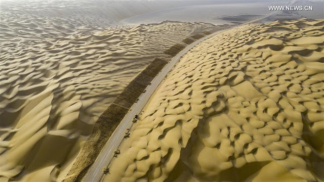
On May 16, 2020, impressive pictures of workers driving bulldozers on a construction site in the Taklamakan Desert were released by Xinhua.
The caption explained: “The construction of Yuli-Qiemo highway, the third north-south route running through Taklamakan Desert, has entered the final rush. Workers of China Communications Construction Company Ltd are working on the largest dune in this project, with an estimated volume of 1.2 million cubic meters of sand to deal with.”

The Yuli-Qiemo highway is a section of the National Highway 216 (known as G216) linking northern Xinjiang to Kyirong county in Tibet (the border town with Nepal). A few years ago, I had mentioned the possibility of having a second road link between the two restive provinces of Tibet and Xinjiang (the first one is the G219 or Aksai Chin road, running through the Indian territory).

Xinhua’s caption continued: “They established camps next to the dune for the convenience of work, and receive daily necessities on a regular basis. The completion of the highway is expected to improve the transport conditions in southern Xinjiang and promote local development.”

For obvious reasons, Beijing does not want to announce as yet that they are building this new highly strategic link, which will serve the under-developed parts of Gerze county of Western Tibet (Ngari Korsum) ...and reached Nepal. It is probably an important part of the Belt & Road Initiative  between Central and South Asia, dreamt by Xi Jinping.

But this is not the trickiest part of the project.
How will the Chinese engineers managed to cross the Kunlun range and reach Rutok county?
Once on the plateau, the terrain (probably via Gerze county) will be easier.
Today many still believe that it is impossible to cross the Kunlun.
But Beijing has probably done its home work and studied the 19th century Western explorers such as Sven Hedin or Aurel Stein who moved around the area and found slightly-easier passages to cut across the formidable natural barrier.
It is interesting to see if this new road link will be included in the next Five-Year Plan (2021-2025).

Some twenty pictures show workers on the lunar ‘dune’ landscape around the future highway crossing the Taklamakan Desert.


Here is a tentative route to be followed by the G216.

Incidentally, on May 14, the Xinjiang Production and Construction Corps (XPCC)  announced that it will pump a lot of funds into transportation projects during the current year.
According to Xinhua: "The [Xinjiang] authorities will invest 9.5 billion yuan (about 1.34 billion U.S. dollars) in 60 major road projects, with plans to build or upgrade roads with a combined length of 2,281 km, according to the local transportation bureau. Of the investment, the Xinjiang Production and Construction Corps will allocate 5.7 billion yuan to its areas of jurisdiction in the southern part of Xinjiang."
It was said that the XPCC has already resumed work on a number of major transportation projects.
It is ominous for the Ladakh border, where the Chinese have started creating serious problems on the Indian side of the LAC, for example in Galwan area and north of the Panggong tso.

Another Section of G216
On May 20, Xinhua published a series of photos showing the construction site of Tianshan Shengli tunnel, a six-year project on the Urumqi-Yuli highway. The news agency says: "it passes through a cold and high altitude zone, with harsh climate and geological condition." This is apparently part of the same G216 Highway project.


Yet another Infrastructure Project in Xinjiang
Tracklaying has started on the Ruoqiang–Hotan railway project south of the Taklamakan Desert.
According to Construction Review Online: “Running east from the current rail-head at Hotan south of Kashgar to Qiemo and then northeast to Ruoqiang, the 825 km line will have 65 stations, serving a string of small towns between the Tarim Basin and the Altun Shan mountain range. It will connect at Ruoqiang with the 1214 km Golmud–Korla line now nearing completion.”
The portal provides further details: “Designed for operation at up to 120 km/h, the single track line was authorised by the National Development and Reform Commission in May 2018. Construction was formally started on December 20 that year, and completion is expected by mid-2022. Capacity is being provided for up to eight daily passenger trains each way and around 15 million tonnes of freight per year. Total cost of the project is put at US 3.1 bn, of which the national government is contributing 54.2%, Xinjiang Uyghur Autonomous Region 23.3% and China Railway 22.5%. This budget includes 790m yuan for rolling stock.”
The Project Manager Zhang Gang of China Railway 14th Bureau Group said that a management and construction team with ‘rich experience in desert railway construction’ to work in the ‘intricate natural environment’ has been working on the project: “the construction teams will be ‘working around the clock’ to lay an average of at least 2km per day. The target is to complete 520km of track and 19 stations by the end of this year.”
China is in a hurry; India should realize this.

Here is my old posting dated 2016:

 The Changthang or ‘Northern plain’ (in Tibetan), occupies a large part of the Tibetan plateau.
In April 2000, with the approval of the State Council, the Changthang National Nature Reserve, located in northern Tibet, south of the Kunlun Mountains, became a national reserve.
It spreads on a total area of 391,200km, which makes it the second largest nature reserve in the world, after the Northeast Greenland National Park.
With the recently-established adjoining reserves, there is now a total of 496,000 km2 of connected Nature Reserves.
The Changthang National Nature Reserve lies at an average elevation of 4,500 meters. Administratively, it comes under the Prefectures of Nagchu and Ngari. Some parts of the Reserve are located in the County of Rutok, bordering Ladakh and the Aksai Chin.
Only a few Tibetan nomads permanently live there, but it is a paradise for wild animals such as wild yak (Bos grunniens), Tibetan wild ass or kiang (Equus kiang), Himalayan blue sheep or Bharal (Pseudois nayaur), Argali (Ovis ammon), Mongolian gazelle (Procapra gutturosa) and Tibetan antelope or chiru (Pantholops hodgsonii). The list of predators is also long; it includes snow leopards (Panthera uncia or Uncia uncia), Tibetan wolves (Canis lupus chanco), Turkestan lynx (Lynx lynx isabellinus) and Tibetan blue bears (Ursus arctos pruinosus).

Road will cut through the eastern part of the Reserve
An Environmental Impact Assessment
Recently, a “Public Announcement for the Environmental Impact Assessment [EIA] of the New Reconstruction Project of National Highway No. 216 (Tibet Area)” was made from Ngari Prefecture in Western Tibet.
According to published abstracts of the EIA: "The State Environmental Protection Bureau of the National Highway 216 (Tibet area) area has basically completed the project environmental impact, for pollution prevention and control.”
(National Highway 216 (G216) runs in the Xinjiang Uyghur Autonomous Region in the southern direction from Altay City to Baluntai in Hejing County, where it joins China National Highway 218. It is 857 kilometres in length). 
The EIA says: “Control measures analysis and evaluation have been completed in accordance with the relevant provisions of the Interim Measures for Public Participation in Environmental Impact Assessment”.
Some ‘relevant’ contents of the EIA have even been made public, probably a first in China.

Here some extracts of the Chinese documents (please excuse inexactitudes; it is a translation through Google language).

I.    Overview of construction projects

The Overview provides an idea of the route followed by the new highway starting from Xinjiang (near Dunhuang? Crescent Lake?) and joining the G 219 (the Aksai Chin road) in the Rutok County.
The Highway will be connecting Xinjiang and Tibet via Minfeng, it should ultimately connect with the Highway G 216 in Xinjiang.
The project is 558 km long.
The deeply-worrying aspect of the project is that it crosses the highly eco-sensitive Changthang National Nature Reserve.
It will run for 110 km in the main reserve, about 270 km in the buffer zone and some 100 km in the ‘experimental area’.
The starting point of this project is the Jieze Lake near the G 219 highway (north of Rutok).
According to the EIA, the road will be built “in accordance with the two-lane highway construction.”
The total investment for the project is RMB 6.453 billion (more than 1 billion US dollars). The construction should start by the end of the current year and the road will be put into operation early 2021. The construction period has been estimated at 48 months.
The main environmental impact assessment says:

1- During the construction period
  1. Noise: The main noise sources during the construction period will be the mechanical bulldozers, the loaders, the excavators and other construction equipment and transportation vehicles. Construction units will carry out the construction work in accordance with the relevant laws and regulations of the State (China) and the Tibet Autonomous Region.
  2. It will be characterized by “a reasonable layout of the construction site; reasonable arrangements for operating time of the work; scientific management and civilized construction [sic]”.
  3. Exhaust gas: Strict implementation of the relevant provisions of the State and the Tibet Autonomous Region will be followed.
  4. Dust: Measures will be taken to minimize the dust: the earth mixer/cement mixer will be closed; the area will be sprinkled; the site will be regularly cleaned; the asphalt mixing station will used ‘good sealing’ materials; high efficiency dust mixing equipment will be used to create the less possible impact on the atmospheric environment.
  5. Wastewater: Construction camps will prevent the seepage of the domestic sewage. After use, the wastewater will go through a sedimentation treatment plant; dust suppression will be taken care of.
  6. Solid wastes: All excavated soils produced by the project shall be reused or transported in closed vehicles. Offloading shall be prohibited to prevent spillage. Earthworks dumps shall be selected according to relevant requirements and measures shall be taken to prevent soil erosion.
  7. Ecological: The construction should be strictly in accordance with the provisions of the approved design. The construction should remain within the scope of plans and it shall not be allowed to expand. At the same time [at the end of the project?] a project evaluation shall seriously be implemented and an assessment made of biological and ecological diversity according with the environment protection laws. At the end of the construction period, timely measures will be taken to reclaim the land (of the construction site).
2 -After the construction period
  1. Environmental noise: Near the sensitive points, speed will be limited and other measures to reduce traffic noise will be taken. Appropriate measures will be taken for the traffic noise in the sensitive areas. The future planning of both sides of the open space should be based on the results of noise assessment.
  2. Ambient air: The air pollution will come mainly from automobile exhausts; the vehicle control, particularly of the automobile exhaust, will be strengthened.
  3. Water environment: During the operation period, the domestic sewage generated from the maintenance area will be treated by anti-seepage aqua plants. Bridge across the river will set up runoff collection systems at both ends of the bridge using sedimentation tanks.
3 - The preliminary conclusions of the EIA report are:
The proposed project is in line with the National Highway Network Plan (2013-2030). The route selection takes full account of the economic, environmental and technical feasibility principles.
It is line with the strict implementation of the ‘three simultaneous’ system, respectively, for the ecological environment, water environment, atmospheric environment.
It takes effective protection measures, will effectively control the adverse environmental impact of roads, along the area to promote economic and social development [of the area]
The project is considered to be viable from the perspective of environmental protection under the premise of obtaining the forest assessment and the biodiversity evaluation report and obtaining the approval of the related project of forestry department.

4 - Seek public views on the main issues
In order to listen to the views and suggestions of the community on the environmental protection work of the national highway 216 (Tibet border) and the 'rebuilt' section of the highway, the project will be publicized to solicit the public's valuable opinions and suggestions.
The main issues include: whether you are aware of the construction of this project; after the completion of the project, your views on the surrounding environment and the impact on your working life; your views and suggestions on environmental protection work.

5 - The public views 
During the ‘publicity period’ for the environmental impact assessment of the project, the public can contact the Construction Unit and the EIA unit.
The public may contact the project construction unit or the EIA unit by way of letter, telephone, e-mail, etc. to obtain supplementary information or to express opinions and opinions on the project construction and EIA work.

The environmental impact assessment unit will record the opinions and suggestions of the public in the environmental impact report of the project and forward the public's valuable opinions and suggestions to the construction unit and the relevant departments of the Government.

Construction Unit:
Key Project Management Center of Transportation Bureau of Ngari District, Tibet Autonomous Region

Evaluation unit:
Beijing Yan State Environmental Technology Development Co., Ltd located in Beijing

Implications for India
This of course does not deal with the strategic implications of the new road which should shorten the time to travel from Urumqi to Rutok (near the Indian border).

Thursday, May 21, 2020

A New Roadblock for India & Nepal

The 1961 map signed by Nepal and China showing the proper alignment of the Kali river
at tallies with Indian claim
My Article A New Roadblock for India & Nepal appeared in Mail Today/DailyO


An argument has recently erupted between India and Nepal, after a 80km new road between Darchula to Lipulekh, the border pass near the trijunction with Tibet and Nepal, was inaugurated by Defence Minister Rajnath Singh. The road is expected to be used by the Indian pilgrims visiting Kailash-Mansarovar, located some 90km from the pass, as well as the local traders, Lipulekh being one of the three authorized landports between India and China.
PTI explained: “The Lipulekh pass is a far western point near Kalapani, a disputed border area between Nepal and India. Both India and Nepal claim Kalapani as an integral part of their territory.”
Kathmandu handed over a diplomatic note protesting against the construction of this vital road to Vinaya Mohan Kwatra, the Indian Ambassador to Nepal; who was subsequently called by Pradeep Kumar Gyawali, Nepal’s Foreign Minister.

Issues at Hand
India’s Ministry of External Affairs (MEA) denied that the road was crossing Nepal’s territory: “The recently inaugurated road section in Pithoragarh district in the state of Uttarakhand lies completely within the territory of India. The road follows the pre-existing route used by the pilgrims of the Kailash Mansarovar Yatra,” said South Block.
Already in November last year, Kathmandu had protested, “unilateral decisions on border issues won’t be accepted,” it was in reference to the new Political Map of India published by Delhi after two new Union Territories - Jammu & Kashmir and Ladakh - came into existence on October 31.
Kathmandu formally protested over the inclusion of the Kalapani area in the new map.
What is strange is that the new Indian map is exactly the same than the one published in 1954 in the Atlas of the Northern Frontiers of India, which is the official reference till today for India’s boundaries. Kathmandu did not protest against the old map and apart from the new UTs, there was nothing new in the 2019 maps.
The case is complicated by different factors; amongst them the political struggle within the ruling party in Nepal and also the fact that there has been no historical consistency in Kathmandu’s position.
Let us look at the history.

Tracing the History
After a War between British India and Nepal in 1814, the Nepalis were sent back across the Kali River in May 1815 and subsequently the Segowli Treaty was signed on March 4, 1816. Article 5 of the Treaty stated: “The Rajah of Nepaul renounces for himself, his heirs and successors, all claim to or connexion with the countries lying to the West of the River Kali, and engages never to have any concern with those countries or the inhabitants thereof.”
Unfortunately, there was no map attached which could have authoritatively shown the exact alignment and the source of the Kali River.
In any case, at that time, no scientific survey worth the name could be carried out; it was only by mid-19th century that the Himalayan border was properly surveyed by the Great Trigonometrical Survey of India (a precursor of the Survey of India).
But more interesting is the “Boundary Treaty between the People's Republic of China and the Kingdom of Nepal” signed by President Liu Shaoqi of China and King Mahendra of Nepal on October 5, 1961: “The Chairman of the People's Republic of China and His Majesty the King of Nepal, being of the agreed opinion that a formal settlement of the question of the boundary between China and Nepal is of fundamental interest to the peoples of the two countries,” said the preamble.
Article I (1) defined the China-Nepal boundary line which “starts from the point where the watershed between the Kali River and the Tinkar River meets the watershed between the tributaries of the Mapchu (Karnali) River on the one hand and the Tinkar River on the other hand…”
Even more interesting are the precise maps attached to the Treaty and signed by both parties; Kathmandu seems to have forgotten that the location of river on the maps of the Sino-Nepali treaty matches with the Indian one, which implies that the road is on Indian territory.
What is however disputed and needs to be negotiated is the area south of the river, where the British (and later Indian) cartographers have taken into account, like everywhere else on the frontiers, the watershed principle as well as the land revenues of Gunji village on the Indian side.
More of such examples of Kathmandu’s inconstancy could be cited.
What presently compounds the issue is the rift within the ruling party’s leadership in Nepal and the role played by China through Hou Yanqi, Beijing’s Ambassador to Kathmandu, the new ‘Queen’ of Nepal, who is credited to have arranged a rapprochement at the top level of the ruling Nepal Communist Party.

Future Impact
An Op-ed in The Indian Express noted: “Shedding its image of being a reluctant player in the internal politics of Nepal, China has been playing an active role these past few days in Kathmandu’s power games.”
Ms Hou Yangqi brokered a truce, with KP Sharma Oli keeping his prime ministerial seat; it is said that President Xi Jinping had a 40-minute phone conversation with Nepal counterpart Bidhya Devi Bhandari, “ostensibly to promise all support to fight the COVID-19 pandemic.”
According to onlinekhabar, on May 12, “In contrast to his foreign affairs minister’s statement that the government was aware of India constructing a link road to Manasarovar encroaching on the Nepali territory in Kalapani region, Prime Minister KP Sharma Oli says he was not told about it.”
There is no doubt about the location of the river and the fact that the new road is inside Indian territory. It is however in Delhi’s interests to find an amicable solution with Nepal for the areas for which there is no agreement; it could avoid China poking its nose into the bilateral affairs between Delhi and Kathmandu in the future.

Saturday, May 16, 2020

The Naku La Incident

Map of Naku La area
Map of Naku La area
As soon as China recovered from the dreaded Covid19, it started a new battle, an Information Warfare (IW) to change the way the world presently perceives the Middle Kingdom. In the process, Beijing found it sometimes necessary to show force, and the recent incident in Northern Sikkim and in Ladakh should be seen in this perspective.
Since the outbreak of the virus in December, the Communist regime discovered that it had not many friends on the planet. Even Vladimir Putin was targeted by Beijing asking the Russian authorities not to discriminate against Chinese citizens; reports had appeared of police raids in Moscow against people from China evading quarantine measures.

The IW counterattack
Soon Beijing decided to counterattack. Zhao Lijian, one of China’s sharp shooters and now a spokesperson of the Ministry of Foreign Affairs, alleged that the Americans were at the origin of the virus.
Another shot came from the Chinese Embassy in Australia who emailed local journalists, accusing them of “politicizing the coronavirus” by saying it originated in China “without any supporting facts.”
Financial Review journalist Michael Smith received an email from the Chinese embassy in Canberra, complaining that he had called the Covid-19, ‘China virus’. Smith asserted that Beijing “has pivoted its propaganda narrative, now insinuating that the virus originated in other countries.”
Later the Chinese ambassador in Australia threatened Canberra: “If you push for an inquiry into the Wuhan lab, we will stop buying your wine”.
The strong-arm technique is a bit gross, but it often works.
The symptoms of the Chinese aggressiveness were also seen on February 18 when Hou Yanqi the Chinese ambassador to Nepal, issued a statement criticizing an article published in the Nepali press: “The Kathmandu Post published an article which, with a picture of malicious intention, deliberately smeared the efforts of the Chinese government and people fighting against the new coronavirus pneumonia and even viciously attacked the political system of China.” The lady ambassador went a step further; she accused by name the chief editor of The Kathmandu Post, Anup Kaphle of being biased.
Examples could be multiplied.

Aggressiveness everywhere
China has not limited the ‘battle’ to the diplomatic field alone; the People’s Liberation Army (PLA) has become aggressive on the ground too.
The recent ‘fights’ in Northern Sikkim and Ladakh are part of the same pattern.
It is a fact that in 2017, despite the conflict at the trijunction between India, Bhutan and China, the Northern Sikkim border was ‘settled’.
In these circumstances, it was rather surprising that Indian and Chinese soldiers recently exchanged blows south of Naku La (pass).
Quoting two senior officials on the condition of anonymity, The Hindustan Times explained: “Scores of Indian and Chinese soldiers were involved in a tense face-off along the India-China boundary in north Sikkim.” In the scuffle several jawans were injured: “Four Indian soldiers and seven Chinese troops suffered injuries during the confrontation that involved around 150 soldiers.”
The confrontation took place south of Naku La, the border pass in the sector and north of Muguthang, a place that China has tried to capture since some time (where incidentally a helicopter of the Indian Air Force had crashed at Dolma Samba), not far away in the same sector, two days before the ‘fight’).
Around the same time, worrying developments were reported from the Northern Ladakh.

The Northern Boundary of Sikkim
The boundary with Tibet (now China) in northern Sikkim can be roughly divided in two parts; the eastern part is delineated by 23 cairns which were erected by Claude White, the British Political Officer (PO) in Sikkim in 1905. Apart from one cairn, known as the ‘Finger’, there is no real difference of perception between India and China. The second part, the western part of Sikkim’s northern border has remained peaceful, as it follows the watershed and is of extremely difficult access (at least for India), with only one pass Chorten Nyima leading to Tibet.
Naku La and Muguthang, a few kilometers south of the pass, are between the western and eastern parts of the boundary.
It is here that Beijing is picking a fight.

Claude White’s Description
Claude White visited the area in 1902, he noted: “I proceeded first up the Naku Chu [river] to the Naku La [pass]. Near the top of the pass, on one I found the usual Tibetan wall, rather better built than is customary, running across the valley with a block-house on the east, and some smaller blockhouse on a ridge coming down from the east. The top of the pass is long, wet and swampy with several lakes. On the way up some very large mineral springs were met with, and sample bottles of each have been sent down to the Chemical Examiner for analysis. This water contains sulphuretted hydrogen, and apparently contains sulphur and iron in large quantities.”
The Chinese would like today to consider the wall as the border; it was built by the Tibetans to protect their pastures in the 19th century; a process often used in the Himalayan region. The wall was similar to a Mani wall (a stone wall with engraved mantras Om Mani Padme Hum); the wall was 5 feet in height and some 800 meters in length. Beijing seems to have decided that the wall was the customary border, neglecting the watershed principle to which they earlier adhered.
The problem for India is that the access to these places is extremely difficult; Muguthang for example is still not connected by road. For several years, the Chinese have tried to ‘realign’ the border; but their claims clearly violate the 1890 Treaty, based on the watershed principle, which they swear by.
If Beijing wanted to put pressure on India, the pass is a convenient acupuncture point and if India gives in, more puncture points will be activated in Ladakh, Barahoti (Uttarakhand), Asaphila (Arunachal Pradesh) and other remote places.
When in June 1902, White went to Northern Sikkim, he met some Tibetan representatives at a place called Gyagong and later at the Naku pass; according to the memoirs of Sir Francis Younghusband: “Mr. White told them that his orders were to lay down the boundary as shown in the Convention of 1890, which had been signed by the Chinese Amban on behalf of the Tibetans.”
The Tibetans did not accept a treaty concerning their country to which they were not a signatory; but Younghusband wrote: “White told them they could see for themselves if the water ran into the Sikkim Valley or into Tibet, and where the water parted into Sikkim and Tibet was the boundary.”
Since then, the top of Naku La (pass) has remained the border.
On July 5, 1905, White had suggested to the Secretary of the Foreign Department in Delhi to erect pillars to mark the border; inter alia, the PO observed: “The number of pillars required would be only ten — one on the Naku La, one on the Sebu La, and eight along the remaining northern boundary from near the Sebu La to Kangchung La,” he added: “There is no necessity for any pillars along the western portion, as it is an inaccessible ridge.”
Probably due to the difficult access, it was found unnecessary to erect a pillar at Naku La, but 23 cairns were built eastwards. The Chinese are today using this historical loophole to open a new front on the Line of Actual Control (LAC).

Why Now?
One could ask, while the issue has been simmering for a few years, why such renewed aggressiveness now? Why is China opening new fronts?
One, in the post-COVID-19 (for China at least), IW is central to the role Beijing wants to play in the world.
As a result, the PLA is bound to be more aggressive on the Indian borders as they may not get their ‘dues’ with the general crunch for funds in Beijing, as a result, their budget will probably be heavily curtailed.
They have to be assertive to be not ‘forgotten’ by the Communist leadership.
Further, it is important to understand that while the terrain is extremely hostile on the Indian side, particularly in the western part of this sector, on the Tibetan side, Kampa Dzong (county) is on a flat plateau; it is where heavy Chinese PLA deployment is now taking place.
According to the website China Defense Blog, the Chinese-made ZTQ-15 light tank is used by the 54th Heavy Armor Combined-Arms Brigade in the Tibet Military Area Command. The new tank is said to have arrived in Kampa Dzong; this could be a game changer.
Another example of Beijing’s new assertiveness: ahead of a crucial Nepal Communist Party meeting, Hou Yanqi, the Chinese ambassador in Kathmandu, held a series of meetings with senior Nepal Communist Party leaders; she blatantly interfered in the ongoing power battle within the ruling party.
Coincidentally, Nepal objected to the new Indian road leading to Lipulekh, the border with China. Kathmandu said that the road is on Nepali territory, forgetting that when Nepal and China signed a border agreement in 1961, a map showing the Kali river, the border, at the same location than on the Indian maps, was published. It is unfortunate, but the NCP leaders are today dictated to by Beijing about what to do or say.
All this together, does not augur well for the coming summer months.


Thursday, May 14, 2020

A long hot summer is ahead on Himalayan heights

Gurudongmar in Northern Sikkim
My article A long hot summer is ahead on Himalayan heights appeared in The Asian Age/Deccan Chronicle

Here is the link...

It is a fact that in early 2017, everyone in New Delhi thought the Sikkim border was a settled issue.

A couple of months before the beginning of the Doklam episode in 2017, Luo Zhaohui, the Chinese ambassador in New Delhi, was invited to deliver a talk at a well-known think tank in the national capital. In the course of his speech, Luo mentioned some “early harvest”. When the moderator, a senior Indian diplomat, asked him what he meant by “early harvest”, Luo enigmatically said it was related to Sikkim. The knowledgeable audience did not really understand what he was trying to convey. It is a fact that in early 2017, everyone in New Delhi thought the Sikkim border was a settled issue.

But on June 16, the Doklam episode started; and we know what happened during the following 73 days.

The border in northern Sikkim nonetheless remained “undisputed”; and Hua Chunyin, the Chinese foreign ministry spokesperson, kept reminding everyone about the importance of the 1890 treaty between the Manchus and British India and asserting the northern border was settled for good.

In these circumstances, it was rather surprising that Indian and Chinese soldiers exchanged blows south of Naku La (pass) in northern Sikkim last week. Defence expert Rahul Singh, writing in a national newspaper, said: “Scores of Indian and Chinese soldiers were involved in a tense face-off along the India-China boundary in north Sikkim.” In the scuffle several jawans were injured. The confrontation took place south of Naku La, the border pass in the sector and north of Muguthang, a place that China has tried to capture for some time.

One Army officer was quoted as saying: “Four Indian soldiers and seven Chinese troops suffered injuries during the confrontation that involved around 150 soldiers.” The incident is said to have later been resolved at the local commanders’ level.

It is true that such incidents took place previously too; one remembers that during the Doklam standoff, Indian and Chinese soldiers exchanged blows in the “Fingers” area, north of the Pangong Lake in Ladakh. One, however, thought that these types of confrontations were a thing of the past.

Wing Commander Mandeep Singh Hooda, the spokesman of the Army’s Eastern Command, oddly equated the two sides, saying: “Aggressive behaviour by the two sides resulted in minor injuries to troops. It was stone-throwing and arguments that ended in a fistfight.”

But can the behaviour of the Indian and Chinese troops be put at the same level? Naku La has been the accepted border pass since the beginning of the last century at least; it was previously never contested by China.

Let us look more closely at the issue.

The boundary with Tibet (now China) in northern Sikkim can be roughly divided in two parts -- the eastern part is delineated by 23 cairns that were built in 1905 by Claude White, the British political officer in Sikkim; there is no real difference of perception between India and China in this sector. The second part, the western part of Sikkim’s northern border, has remained peaceful as it follows the watershed and is of extremely difficult access (at least for India).

Naku La and Muguthang, a few kilometers south of the pass, are between the western and eastern parts of the boundary.

It is here that Beijing is picking a fight.

The Chinese say that a couple of kilometres south of Naku La, the Tibetans had built a wall to protect their pastures in the 19th century; a process often used in the Himalayan region. The wall was five feet high and some 800 meters in length. Now China is claiming the wall was the customary border, neglecting the watershed principle used elsewhere.

The problem for India is that access to these places is extremely difficult; Muguthang for example is still not connected by road. For several years, the Chinese have tried to “realign” the border; but their claims clearly violate the 1890 treaty, which they swear by, and are based on the watershed principle. However, when Beijing wants to put pressure on India, the pass is a convenient acupuncture point and if India gives up, more puncture points will be activated in Ladakh, Barahoti (Uttarakhand), Asaphila (Arunachal Pradesh) and other remote places.

While the terrain is extremely hostile on the Indian side, particularly in the western part of this sector, on the Tibetan side, Kampa Dzong (county) is on a flat plateau; it is where heavy Chinese PLA deployment is taking place.

According to the website China Defense Blog, the Chinese-made ZTQ-15 light tank is used by the 54th Heavy Armour Combined-Arms Brigade in the Tibet Military Area Command: “The new light tank was unveiled to the public during the Zhuhai Air Show in China in November 2016.”

Another specialised website armyrecognition.com said the Type 15 tank “was designed… as a lighter, mobile modern tank that can effectively operate in China’s plateaus, forests, and water-heavy regions in which heavier tanks have difficulties traversing”. The new tank is said to have arrived in Kampa Dzong; if true, this could be a game-changer.

One could ask, while the issue has been simmering for a few years, why such renewed aggressiveness now?

One of the reasons is that post-Covind-19, the PLA, which played a decisive role in controlling the pandemic, is keen to continue to have a visible role in the Middle Kingdom, even if its budget is bound to get serious cuts. To be aggressive in the South China Sea or in the Himalayas is a way to remind Beijing’s leaders that the PLA should not be forgotten.

Another motive is the coming meeting of the World Health Organisation. On May 22, India’s nominee is expected to be appointed chairperson of the WHO’s executive board, which is responsible for executing decisions and implementing policies of the organisation. India will replace Japan, which completes its one-year-term.

The Wion website explained: “It implies that the WHO director-general will have to get the chairperson -- India -- on board for all important decisions.”

One can understand the stakes for China, which wants to avoid any serious enquiry into the origin of the dreaded virus.

The Naku La incident is a way to tell New Delhi: “You behave, or we shall press other painful points.” Australia was similarly threatened by the Chinese ambassador in Canberra: “If you push for an inquiry into the Wuhan lab, we will stop buying your wine”.

It is a bit gross, but it often works.

One thing is sure: “Early Harvests” are not for tomorrow.

The Himalayan summer that lies ahead is bound to be a hot one.

Wednesday, May 6, 2020

The role Chinese army played in the pandemic

My article The role Chinese army played in the pandemic appeared in Mail Today/DailyO


Here is the link...

From Day One, a PLA unit has been on the central stage of what the Communist Party of China called the 'People's War' against the 'demon' virus.
We all know that the world will be different once the coronavirus crisis is over; very few countries will be spared. China, the origin of the virus, whether it came from the wet market or the Wuhan Institute of Virology, will never be the same too; more importantly, the Middle Kingdom will never be perceived as before. Further, Beijing is bound to face tremendous economic difficulties. Will Beijing be able to find innovative solutions and the Communist regime be able to adapt to the new realities? It remains to be seen.

Handpicked by Xi
In this context, it is interesting to look at the role played by the People's Liberation Army (PLA) during the pandemic and at the future of the Chinese Armed Forces, which could become far more aggressive in view of the general economic slowdown. From Day One, a PLA unit, the Joint Logistics Support Force (JLSF), has been on the central stage of what the Communist Party of China called the 'People's War' against the 'demon' virus.
There is no doubt that the Communist authorities were lax, to say the least, during the first weeks; it is only on January 23, more than one or two months after the apparition of the first cases of coronavirus pneumonia, that the Joint Logistics Support Force (JLSF) troops entered the stage. The Force was created on January 11, 2016 as part of Xi Jinping's Dream of a rejuvenated China with a modern powerful and efficient Army; according to Xinhua, it "comprises the support forces for inventory and warehousing, medical services, transport, force projection, oil pipelines, engineering and construction management, reserve assets management, and procurement." Coincidentally, it is based in Wuhan. Interestingly, on October 18, 2019, President Xi Jinping, also Chairman of the Central Military Commission (CMC), flew to Wuhan to attend the first JLSF Party Congress. According to Xinhua, Xi Jinping encouraged the JLSF delegates and other senior officers stationed in Hubei province "to faithfully perform their duties and contribute to fulfilling the dream of a strong military." The tasks for the JLSF were already clearly defined and once the COVID-19 broke out, it was soon implemented on the ground; in fact, it became a mega military exercise for the Force. The PLA immediately made the headlines by building the Huoshenshan 1000-bed field hospital in 10 days.
During the entire crisis, China has demonstrated an amazing opacity, whether it is about the origin of the virus or the number of infected cases and casualties, while Xi's presence remained central to the propaganda. At a press conference on March 2, Maj Gen Chen Jingyuan, Director of the health division of the Logistic Support Department made an astounding statement; he announced that the pneumonia outbreak did not cause cases of infection among the involved PLA personnel, while it improved the combat readiness of the Chinese military instead. One can believe the second part of the statement, but the first part can only make one smile.

Lack of transparency
Significantly, it was from the command centre at Huoshenshan hospital, that on March 10, Xi announced the 'Victory'. Five weeks later, Xi signed an order of commendation to honour all the military personnel who participated; the order said: "The whole military has resolutely carried out the decisions and commands of the Communist Party and the CMC and shouldered heavy responsibilities, making outstanding contributions to winning the people's war against the epidemic." Commendation is one thing, but what will happen to PLA post coronavirus crisis is another; the Armed Forces may be cut.
The Global Times already announced that the military budget will be hit …only mildly. The budget figure is expected to be announced at China's annual two sessions, to be held at the end of May: "The defense budget may grow more slowly than in 2019, rising to about 1.27 trillion yuan ($179 billion), or it may fall to only 1 trillion yuan," some knowledgeable analysts predicted. If it is so, this projection is not mild, it is more than a 20% official cut. Will this be taken 'mildly' by the PLA victors? It is doubtful.
In recent weeks, China has shown a renewed aggression, whether it is in the South China Sea or on the Indian borders. On April 18, Sky Map, the Chinese public service platform working under the National Surveying and Mapping of China published new digital maps. At one point, Sky Map updated the map information and 'inadvertently' disclosed China's borders' claims, particularly in the area that they called 'South Tibet', i.e. the Indian State of Arunachal Pradesh.
Was this new aggression necessary at this point in time? In the meantime, the infrastructure in Tibet on India's borders has restarted on a war footing, even while public places, such as the Potala Palace in Lhasa, are still closed.

Another Doklam ploy?
On April 7, Xinhua reported that the construction on the last two of the 47 tunnels on a 435-km railway linking Lhasa and Nyingchi, near the Indian border of Arunachal Pradesh, had been completed "marking huge progress for the mammoth project." One tunnel is 11.5 km long, while the other is 8.7 km. Examples could be multiplied, particularly an electricity mega project near the Ladakh border in Western Tibet employing 4,000 workers and the PLA aggressive posture in Northern Sikkim or Upper Subansiri district. Historically, when the PLA does not get its 'dues', it starts diverting its aggressiveness towards external targets; in which case, a new Doklam is always possible.