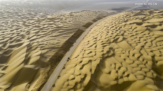
Beijing starts construction of strategic Xinjiang-Tibet highway, which will bring the greatest strategic change for India since the 1950s, as it will be an alternate artery for the Dragon to fortify its presence along the LAC.
On 27 May 1951, the Ashi Shan (mountain) volcano erupted in the Xinjiang province of China. It began with a loud detonation, followed by the ejection of large blocks of lava, emitting thick black smoke, and lasted for a number of days.
The Ashi volcano, the highest volcano in the northern hemisphere, is part of a group of about 70 cinder cones in the Kunlun range, at the border of Tibet’s Northern Plain (Changthang). The 1951 eruption remains the most recent volcanic activity in China. What is unknown is the other story behind the eruption in this most desolate area.
In the early 1950s, Mao Zedong’s People’s Liberation Army (PLA) was desperate to link its two recently acquired provinces of Sinkiang (today Xinjiang) and Tibet. The country of the Uighurs, also known as Eastern Turkestan, had been annexed in December 1949, while Eastern Tibet was invaded in October 1950. It was a matter of national priority to discover a route between Xinjiang and Tibet.
In 1951, when the PLA decided to cross the massive Kunlun range along the Keryia Ancient Road in Hotan County, it encountered the Ashi Shan. It is then that the volcano erupted. Many road workers were killed in the mishap, and the plan to build a road through the Keryia route was abandoned. Mao had no choice but to find an alternative.
It is how the G219 National Highway Xinjiang-Tibet Road, as we know it today, was selected. The road crossed through Indian territory in the Aksai Chin, but this was not an issue which bothered the Great Helmsman.
Chinese leaders never forget the dreams of their predecessors. Today, one of the most secret projects of President Xi Jinping is to open a new link between Xinjiang and Tibet, the two restive autonomous regions bordering India.
It appears that China has recently started the construction of the National Highway 216 (known as G216), linking northern Xinjiang to Kyirong County in Tibet (the border town with Nepal). But for India, the G216 will bring the greatest strategic change since the 1950s, as it will be an alternate artery for China to reinforce the northern India front.
According to the ‘National Highway Network Planning (2013-2030)’, the G216 runs from Hongshanzui Port (in Altay County, north of the Xinjiang Uyghur Autonomous Region or XUAR) in direction of Baluntai in Hejing County, where it joins China National Highway 218, then moves to Luntai County entering the Taklamakan desert till Minfeng County. It then proceeds to Garze County in Tibet, to finally reach Kyirong.
For obvious reasons, Beijing does not want to announce as yet that it has started the construction of the highly-strategic road-link. For Beijing, it is also an important part of Xi Jinping’s Belt and Road Initiative (BRI) between Central and South Asia, and in case of a conflict with India, it will be a great boon for the PLA.
The crossing of the Kunlun range is still the trickiest part of the project. How will the Chinese engineers manage to cross the mountainous range? Once on the plateau, the terrain (via Gerze County) will be easier. But old dreams of megalomaniac rulers cannot be dropped.
Today, there is little information on the G216. However, a Chinese website provides some details on the history of the road. It says: “Xinjiang and Tibet are two giant autonomous regions occupying nearly one-third of China’s landmass; the boundary between the two autonomous regions is more than 1,300 kilometres.”
The main issue for Beijing is that, “due to the barrier of the Kunlun Mountains and the harsh natural environment of the northern Tibet Plateau, the number of practical passages is limited… Therefore, in history, the Western Regions and the Tibetan Plateau were relatively independent geographical areas, and they did not communicate closely with each other”.
It then makes an interesting remark: “The boundary between Tibet and Xinjiang is not divided according to the boundary of the plateau, but roughly the southern foot of the main Kunlun Mountains is Tibet.” It practically means that the Kunlun range is still the natural frontier between India and China. The crossing of the Kunlun range is clearly the passage between two worlds.
There were several ancient routes to Tibet crossing the Kunlun mountains. In the early days, there were several passages: The Keliyang trail, southwest of Hotan, leading to Aksai Chin, the Sanju ancient trade road, which is now being revived, and the Keriya Trail, which was abandoned due to the 1951 volcano eruption, but is still “the shortest of several ancient roads and also the most difficult and dangerous one”.
The Keliyang and the Sanju ancient roads end up in Shahidullah (‘martyr’ in Uighur). In 1949, it continued to be a main hub in the region after “the actual control of the two places returned to the central government [Beijing].” The conclusion is: “to strengthen the communication and ties between the two regions, the linking of the highways is urgently needed to be put on the agenda.”
The article further confirms that according to the national highway network plan, during the period 2013-2030, two new corridors will be built to connect Xinjiang with Tibet. The G216 National Highway is one of them: “Its main section is almost parallel to the ancient Keryia Road and is located on the east side of the ancient road, creating a closest connection line from Urumqi to Lhasa.”
The author adds: “In addition, the Hotan area also has a local road network ‘three horizontal and three vertical’ plans, and these ‘three verticals’ are all related to crossing the Kunlun Mountains.”
One of the verticals is the G580 National Highway, the second vertical is the Keryia Highway (G216) which enters Tibet near Heishi Lake, and the third vertical is the Sanju Highway constructed almost along the route of the Sanju ancient road in Pishan County. “As a result, the highway across the Kunlun Mountains will become a network,” concludes the article.
Interestingly, the article mentions the proposed Tibet-Xinjiang railway running via the Aksai Chin: “Since the final route plan of the Xinjiang-Tibet Railway has not yet been released, Yecheng Station, which is temporarily regarded as the starting point of the Xinjiang-Tibet Railway, will also be continuously improved for the Xinjiang-Tibet highway network. If the Yecheng Station is not really where the train arrives, Moyu (Karakash) Station or Hotan Stations might be the starting point.”
All this is worrying. Will the Indian government follow its usual ostrich-like policy or will it react? If it does not, it will have implications for several decades for India, like the Aksai Chin blunder in the 1950s.
Showing posts with label G219. Show all posts
Monday, January 11, 2021
Beware, India! China’s Most Strategic Road
My article Beware, India! China’s Most Strategic Road is Coming appeared in The Daily Guardian
Saturday, May 23, 2020
A new road between Tibet and Xinjiang
![]() |
| G216 cutting across the Taklamakan Desert |
The caption explained: “The construction of Yuli-Qiemo highway, the third north-south route running through Taklamakan Desert, has entered the final rush. Workers of China Communications Construction Company Ltd are working on the largest dune in this project, with an estimated volume of 1.2 million cubic meters of sand to deal with.”
The Yuli-Qiemo highway is a section of the National Highway 216 (known as G216) linking northern Xinjiang to Kyirong county in Tibet (the border town with Nepal). A few years ago, I had mentioned the possibility of having a second road link between the two restive provinces of Tibet and Xinjiang (the first one is the G219 or Aksai Chin road, running through the Indian territory).
Xinhua’s caption continued: “They established camps next to the dune for the convenience of work, and receive daily necessities on a regular basis. The completion of the highway is expected to improve the transport conditions in southern Xinjiang and promote local development.”
For obvious reasons, Beijing does not want to announce as yet that they are building this new highly strategic link, which will serve the under-developed parts of Gerze county of Western Tibet (Ngari Korsum) ...and reached Nepal. It is probably an important part of the Belt & Road Initiative between Central and South Asia, dreamt by Xi Jinping.
But this is not the trickiest part of the project.
How will the Chinese engineers managed to cross the Kunlun range and reach Rutok county?
Once on the plateau, the terrain (probably via Gerze county) will be easier.
Today many still believe that it is impossible to cross the Kunlun. But Beijing has probably done its home work and studied the 19th century Western explorers such as Sven Hedin or Aurel Stein who moved around the area and found slightly-easier passages to cut across the formidable natural barrier.
It is interesting to see if this new road link will be included in the next Five-Year Plan (2021-2025).
Some twenty pictures show workers on the lunar ‘dune’ landscape around the future highway crossing the Taklamakan Desert.
Here is a tentative route to be followed by the G216.
![]() |
Incidentally, on May 14, the Xinjiang Production and Construction Corps (XPCC) announced that it will pump a lot of funds into transportation projects during the current year.
According to Xinhua: "The [Xinjiang] authorities will invest 9.5 billion yuan (about 1.34 billion U.S. dollars) in 60 major road projects, with plans to build or upgrade roads with a combined length of 2,281 km, according to the local transportation bureau. Of the investment, the Xinjiang Production and Construction Corps will allocate 5.7 billion yuan to its areas of jurisdiction in the southern part of Xinjiang."
It was said that the XPCC has already resumed work on a number of major transportation projects.
It is ominous for the Ladakh border, where the Chinese have started creating serious problems on the Indian side of the LAC, for example in Galwan area and north of the Panggong tso.
Another Section of G216
On May 20, Xinhua published a series of photos showing the construction site of Tianshan Shengli tunnel, a six-year project on the Urumqi-Yuli highway. The news agency says: "it passes through a cold and high altitude zone, with harsh climate and geological condition." This is apparently part of the same G216 Highway project. According to Construction Review Online: “Running east from the current rail-head at Hotan south of Kashgar to Qiemo and then northeast to Ruoqiang, the 825 km line will have 65 stations, serving a string of small towns between the Tarim Basin and the Altun Shan mountain range. It will connect at Ruoqiang with the 1214 km Golmud–Korla line now nearing completion.”
The portal provides further details: “Designed for operation at up to 120 km/h, the single track line was authorised by the National Development and Reform Commission in May 2018. Construction was formally started on December 20 that year, and completion is expected by mid-2022. Capacity is being provided for up to eight daily passenger trains each way and around 15 million tonnes of freight per year. Total cost of the project is put at US 3.1 bn, of which the national government is contributing 54.2%, Xinjiang Uyghur Autonomous Region 23.3% and China Railway 22.5%. This budget includes 790m yuan for rolling stock.”
The Project Manager Zhang Gang of China Railway 14th Bureau Group said that a management and construction team with ‘rich experience in desert railway construction’ to work in the ‘intricate natural environment’ has been working on the project: “the construction teams will be ‘working around the clock’ to lay an average of at least 2km per day. The target is to complete 520km of track and 19 stations by the end of this year.”
China is in a hurry; India should realize this.
The Changthang or ‘Northern plain’ (in Tibetan), occupies a large part of the Tibetan plateau.
In April 2000, with the approval of the State Council, the Changthang National Nature Reserve, located in northern Tibet, south of the Kunlun Mountains, became a national reserve.
It spreads on a total area of 391,200km, which makes it the second largest nature reserve in the world, after the Northeast Greenland National Park.
With the recently-established adjoining reserves, there is now a total of 496,000 km2 of connected Nature Reserves.
The Changthang National Nature Reserve lies at an average elevation of 4,500 meters. Administratively, it comes under the Prefectures of Nagchu and Ngari. Some parts of the Reserve are located in the County of Rutok, bordering Ladakh and the Aksai Chin.
Only a few Tibetan nomads permanently live there, but it is a paradise for wild animals such as wild yak (Bos grunniens), Tibetan wild ass or kiang (Equus kiang), Himalayan blue sheep or Bharal (Pseudois nayaur), Argali (Ovis ammon), Mongolian gazelle (Procapra gutturosa) and Tibetan antelope or chiru (Pantholops hodgsonii). The list of predators is also long; it includes snow leopards (Panthera uncia or Uncia uncia), Tibetan wolves (Canis lupus chanco), Turkestan lynx (Lynx lynx isabellinus) and Tibetan blue bears (Ursus arctos pruinosus).
![]() |
| Road will cut through the eastern part of the Reserve |
Recently, a “Public Announcement for the Environmental Impact Assessment [EIA] of the New Reconstruction Project of National Highway No. 216 (Tibet Area)” was made from Ngari Prefecture in Western Tibet.
According to published abstracts of the EIA: "The State Environmental Protection Bureau of the National Highway 216 (Tibet area) area has basically completed the project environmental impact, for pollution prevention and control.”
(National Highway 216 (G216) runs in the Xinjiang Uyghur Autonomous Region in the southern direction from Altay City to Baluntai in Hejing County, where it joins China National Highway 218. It is 857 kilometres in length).
The EIA says: “Control measures analysis and evaluation have been completed in accordance with the relevant provisions of the Interim Measures for Public Participation in Environmental Impact Assessment”.
Some ‘relevant’ contents of the EIA have even been made public, probably a first in China.
Here some extracts of the Chinese documents (please excuse inexactitudes; it is a translation through Google language).
I. Overview of construction projects
The Overview provides an idea of the route followed by the new highway starting from Xinjiang (near Dunhuang? Crescent Lake?) and joining the G 219 (the Aksai Chin road) in the Rutok County.
The Highway will be connecting Xinjiang and Tibet via Minfeng, it should ultimately connect with the Highway G 216 in Xinjiang.
The project is 558 km long.
The deeply-worrying aspect of the project is that it crosses the highly eco-sensitive Changthang National Nature Reserve.
It will run for 110 km in the main reserve, about 270 km in the buffer zone and some 100 km in the ‘experimental area’.
The starting point of this project is the Jieze Lake near the G 219 highway (north of Rutok).
According to the EIA, the road will be built “in accordance with the two-lane highway construction.”
The total investment for the project is RMB 6.453 billion (more than 1 billion US dollars). The construction should start by the end of the current year and the road will be put into operation early 2021. The construction period has been estimated at 48 months.
The main environmental impact assessment says:
1- During the construction period
- Noise: The main noise sources during the construction period will be the mechanical bulldozers, the loaders, the excavators and other construction equipment and transportation vehicles. Construction units will carry out the construction work in accordance with the relevant laws and regulations of the State (China) and the Tibet Autonomous Region.
- It will be characterized by “a reasonable layout of the construction site; reasonable arrangements for operating time of the work; scientific management and civilized construction [sic]”.
- Exhaust gas: Strict implementation of the relevant provisions of the State and the Tibet Autonomous Region will be followed.
- Dust: Measures will be taken to minimize the dust: the earth mixer/cement mixer will be closed; the area will be sprinkled; the site will be regularly cleaned; the asphalt mixing station will used ‘good sealing’ materials; high efficiency dust mixing equipment will be used to create the less possible impact on the atmospheric environment.
- Wastewater: Construction camps will prevent the seepage of the domestic sewage. After use, the wastewater will go through a sedimentation treatment plant; dust suppression will be taken care of.
- Solid wastes: All excavated soils produced by the project shall be reused or transported in closed vehicles. Offloading shall be prohibited to prevent spillage. Earthworks dumps shall be selected according to relevant requirements and measures shall be taken to prevent soil erosion.
- Ecological: The construction should be strictly in accordance with the provisions of the approved design. The construction should remain within the scope of plans and it shall not be allowed to expand. At the same time [at the end of the project?] a project evaluation shall seriously be implemented and an assessment made of biological and ecological diversity according with the environment protection laws. At the end of the construction period, timely measures will be taken to reclaim the land (of the construction site).
- Environmental noise: Near the sensitive points, speed will be limited and other measures to reduce traffic noise will be taken. Appropriate measures will be taken for the traffic noise in the sensitive areas. The future planning of both sides of the open space should be based on the results of noise assessment.
- Ambient air: The air pollution will come mainly from automobile exhausts; the vehicle control, particularly of the automobile exhaust, will be strengthened.
- Water environment: During the operation period, the domestic sewage generated from the maintenance area will be treated by anti-seepage aqua plants. Bridge across the river will set up runoff collection systems at both ends of the bridge using sedimentation tanks.
The proposed project is in line with the National Highway Network Plan (2013-2030). The route selection takes full account of the economic, environmental and technical feasibility principles.
It is line with the strict implementation of the ‘three simultaneous’ system, respectively, for the ecological environment, water environment, atmospheric environment.
It takes effective protection measures, will effectively control the adverse environmental impact of roads, along the area to promote economic and social development [of the area]
The project is considered to be viable from the perspective of environmental protection under the premise of obtaining the forest assessment and the biodiversity evaluation report and obtaining the approval of the related project of forestry department.
4 - Seek public views on the main issues
In order to listen to the views and suggestions of the community on the environmental protection work of the national highway 216 (Tibet border) and the 'rebuilt' section of the highway, the project will be publicized to solicit the public's valuable opinions and suggestions.
The main issues include: whether you are aware of the construction of this project; after the completion of the project, your views on the surrounding environment and the impact on your working life; your views and suggestions on environmental protection work.
5 - The public views
During the ‘publicity period’ for the environmental impact assessment of the project, the public can contact the Construction Unit and the EIA unit.
The public may contact the project construction unit or the EIA unit by way of letter, telephone, e-mail, etc. to obtain supplementary information or to express opinions and opinions on the project construction and EIA work.
The environmental impact assessment unit will record the opinions and suggestions of the public in the environmental impact report of the project and forward the public's valuable opinions and suggestions to the construction unit and the relevant departments of the Government.
Construction Unit:
Key Project Management Center of Transportation Bureau of Ngari District, Tibet Autonomous Region
Evaluation unit:
Beijing Yan State Environmental Technology Development Co., Ltd located in Beijing
Implications for India
This of course does not deal with the strategic implications of the new road which should shorten the time to travel from Urumqi to Rutok (near the Indian border).
Thursday, May 17, 2018
Why India needs to keep a tab on the new silk road
My article Why India needs to keep a tab on the new silk road appeared in Mail Today/DailyO
Linking Xinjiang to south Asia seems to be a new dream for the leadership in Beijing.
Here is the link...
After focusing for years on Lhasa and southern Tibet, Beijing has decided to invest in the development of western Tibet, known as the Ngari Prefecture of the Tibetan Autonomous Region (TAR). Despite the 2015 Nepal earthquake which delayed the building of infrastructure in the area, particularly the railway line Lhasa-Kyirong at the Nepal border, the work has now started at an accelerated pace.
Economic angle
One project which could have serious strategic implications for India is the extension of the National Highway G216 from Xinjiang to Kyirong landport; linking Xinjiang to south Asia seems to be a new dream for the leadership in Beijing. Though technically it is a formidable challenge to cross the Kunlun range, the Chinese engineers are determined to implement the scheme.
This could also have immense economic consequences as it may become the main conduit of a new Silk Road from Central Asia to Nepal and South Asia. Has India been taken into the loop when Prime Minister Narendra Modi "informally" met the Chinese president recently? It is doubtful.
Meanwhile, western Tibet develops fast. In January, VTIBET.com reported that the Ngari prefecture received over 6,60,000 visitors in 2017. The statistics released by the Ngari Tourism Bureau website said that it was a 20 per cent growth compared to the previous year. Even the revenue increased.
“The tourism revenue totalled about 750 million yuan, up by 10 per cent over the same period last year.” The website cites the prefecture’s marvels: the Kailash Manasarovar area, the ruins of the former Guge Kingdom and the Tholing Clay Forest — all located in Ngari Prefecture.
Last month, Radio Free Asia (RFA) announced that the Chinese authorities have seized farmland in Lhatse to build a new airport, “displacing Tibetan villagers and offering far less in compensation than the land is worth”. RFA argued that the land belonged to Yushang village in Shigatse prefecture’s Lhatse county.
Apart from the deprivation of the land, the news item shows that in the years to come, Western Tibet could become the new economic and touristic hub and, of course, an important strategic centre for the defence of China’s borders. The opening of a new airport should be seen in this perspective, though the rapidly increasing trade with Nepal shouldn’t be ignored.
According to Tibet Business Daily, the total value of Tibet’s foreign trade exceeded 5.8 billion yuan (nearly Rs 6,700 crore) in 2017. “The domestic economy has been steadily improving, and the demand for international market has generally recovered,” noted the daily.
Nepal is the main recipient of Tibet’s exports. In April, Nepal’s foreign minister, Pradeep Gyawali, visited Beijing. After meeting vice-president Wang Qishan and his Chinese counterpart Wang Yi, he spoke of “expediting past agreements, developing trans-Himalayan multidimensional transport network and building a China-Nepal-India economic corridor.”
Gyawali noted that China is Nepal’s genuine friend and a trusted ally. “We should build on the excellent roots of civilisational, geographical and cultural affinities to further connect our countries and societies.” This new civilisational bond between China and Nepal explains the need of a new airport in Lhatse.
Difficult terrain
China Tibet News Network mentioned another megaproject, the "extension" of the G216 Highway which, according to the article, will end in Kyirong. What does the extension of G216 mean?
In 2016, a "Public Announcement for the Environmental Impact Assessment (EIA) of G216 (Tibet Area)" was made. The original 857-km-long highway starts from Altay City in northern Xinjiang and ends in Baluntai (in Hejing County). It will now be extended via Minfeng and Keryia in southern Xinjiang to western Tibet and Nepal.
Needless to mention the immense technical challenge to cross the Kunlun range between Keryia and Rutok where the road will join the G219 or Aksai Chin road. To give an idea, Keryia is located at 1,459m sea level, while Lake Lighten on the plateau is at 5080m (a 3,500m climb in less than 200km). It is perhaps the most difficult terrain in the world.
Crazy dream
The last section of the "extended" G216 (towards Nepal) will have a length of about 94km; the geological conditions are complex, said a Chinese website: “After experiencing the May 12, 2015 earthquake in Nepal, the geological conditions are even more unpredictable. The original roads at the Kyirong Port have been seriously damaged, and the subgrade has subsided in some sections.”
The main bridge in this section is said to have collapsed “and the road surface was broken and cracked.” Kyirong is located 24km away from the Nepal border; it is now the main channel for land trade between China and the former kingdom.
Due to the earthquake, the railway line between Shigatse and Kyirong has been delayed by at least three years. After the earthquake, one section of the G216 slipped and is no longer accessible. The road from Kyirong to the border with Nepal is only a dirt road. “When the rainy season arrives, disasters such as landslides and mudslides are frequent.”
The point remains that if the terminal section of G216 towards Kyirong is difficult, it is nothing compared to the section which will try to cross the Kunlun range, north of Lake Lighten. One more crazy dream of the rulers in Beijing?
Or a visionary project in view of the importance of having a second Xinjiang-Tibet highway (after the Aksai Chin road built in the early 1950s)? Could it be a true New Silk Road linking Central Asia to South Asia via Nepal? It is difficult to say today. The engineers have to cross the Kunlun first. India should watch the developments.
Linking Xinjiang to south Asia seems to be a new dream for the leadership in Beijing.
Here is the link...
After focusing for years on Lhasa and southern Tibet, Beijing has decided to invest in the development of western Tibet, known as the Ngari Prefecture of the Tibetan Autonomous Region (TAR). Despite the 2015 Nepal earthquake which delayed the building of infrastructure in the area, particularly the railway line Lhasa-Kyirong at the Nepal border, the work has now started at an accelerated pace.
Economic angle
One project which could have serious strategic implications for India is the extension of the National Highway G216 from Xinjiang to Kyirong landport; linking Xinjiang to south Asia seems to be a new dream for the leadership in Beijing. Though technically it is a formidable challenge to cross the Kunlun range, the Chinese engineers are determined to implement the scheme.
This could also have immense economic consequences as it may become the main conduit of a new Silk Road from Central Asia to Nepal and South Asia. Has India been taken into the loop when Prime Minister Narendra Modi "informally" met the Chinese president recently? It is doubtful.
Meanwhile, western Tibet develops fast. In January, VTIBET.com reported that the Ngari prefecture received over 6,60,000 visitors in 2017. The statistics released by the Ngari Tourism Bureau website said that it was a 20 per cent growth compared to the previous year. Even the revenue increased.
“The tourism revenue totalled about 750 million yuan, up by 10 per cent over the same period last year.” The website cites the prefecture’s marvels: the Kailash Manasarovar area, the ruins of the former Guge Kingdom and the Tholing Clay Forest — all located in Ngari Prefecture.
Last month, Radio Free Asia (RFA) announced that the Chinese authorities have seized farmland in Lhatse to build a new airport, “displacing Tibetan villagers and offering far less in compensation than the land is worth”. RFA argued that the land belonged to Yushang village in Shigatse prefecture’s Lhatse county.
Apart from the deprivation of the land, the news item shows that in the years to come, Western Tibet could become the new economic and touristic hub and, of course, an important strategic centre for the defence of China’s borders. The opening of a new airport should be seen in this perspective, though the rapidly increasing trade with Nepal shouldn’t be ignored.
According to Tibet Business Daily, the total value of Tibet’s foreign trade exceeded 5.8 billion yuan (nearly Rs 6,700 crore) in 2017. “The domestic economy has been steadily improving, and the demand for international market has generally recovered,” noted the daily.
Nepal is the main recipient of Tibet’s exports. In April, Nepal’s foreign minister, Pradeep Gyawali, visited Beijing. After meeting vice-president Wang Qishan and his Chinese counterpart Wang Yi, he spoke of “expediting past agreements, developing trans-Himalayan multidimensional transport network and building a China-Nepal-India economic corridor.”
Gyawali noted that China is Nepal’s genuine friend and a trusted ally. “We should build on the excellent roots of civilisational, geographical and cultural affinities to further connect our countries and societies.” This new civilisational bond between China and Nepal explains the need of a new airport in Lhatse.
Difficult terrain
China Tibet News Network mentioned another megaproject, the "extension" of the G216 Highway which, according to the article, will end in Kyirong. What does the extension of G216 mean?
In 2016, a "Public Announcement for the Environmental Impact Assessment (EIA) of G216 (Tibet Area)" was made. The original 857-km-long highway starts from Altay City in northern Xinjiang and ends in Baluntai (in Hejing County). It will now be extended via Minfeng and Keryia in southern Xinjiang to western Tibet and Nepal.
Needless to mention the immense technical challenge to cross the Kunlun range between Keryia and Rutok where the road will join the G219 or Aksai Chin road. To give an idea, Keryia is located at 1,459m sea level, while Lake Lighten on the plateau is at 5080m (a 3,500m climb in less than 200km). It is perhaps the most difficult terrain in the world.
Crazy dream
The last section of the "extended" G216 (towards Nepal) will have a length of about 94km; the geological conditions are complex, said a Chinese website: “After experiencing the May 12, 2015 earthquake in Nepal, the geological conditions are even more unpredictable. The original roads at the Kyirong Port have been seriously damaged, and the subgrade has subsided in some sections.”
The main bridge in this section is said to have collapsed “and the road surface was broken and cracked.” Kyirong is located 24km away from the Nepal border; it is now the main channel for land trade between China and the former kingdom.
Due to the earthquake, the railway line between Shigatse and Kyirong has been delayed by at least three years. After the earthquake, one section of the G216 slipped and is no longer accessible. The road from Kyirong to the border with Nepal is only a dirt road. “When the rainy season arrives, disasters such as landslides and mudslides are frequent.”
The point remains that if the terminal section of G216 towards Kyirong is difficult, it is nothing compared to the section which will try to cross the Kunlun range, north of Lake Lighten. One more crazy dream of the rulers in Beijing?
Or a visionary project in view of the importance of having a second Xinjiang-Tibet highway (after the Aksai Chin road built in the early 1950s)? Could it be a true New Silk Road linking Central Asia to South Asia via Nepal? It is difficult to say today. The engineers have to cross the Kunlun first. India should watch the developments.
Labels:
Aksai Chin road,
G216,
G219,
Keriya,
Kunlun,
Kyirong,
Ngari,
Western Tibet
Friday, January 13, 2017
New highway near Mt. Kailash
The Chinese Law on Environmental Impact Assessment (EIA) requires the State to consult the population about any new project; it is how some information on the new highway projects in Western Tibet (Ngari Prefecture) came in the public domain.
Last week I had mentioned the construction of a 558 km-long highway connecting Xinjiang and Tibet, via Minfeng.
The deeply-worrying aspect of this project is that it crosses the highly eco-sensitive Changthang National Nature Reserve. It runs for 110 km in the main reserve, about 270 km in the buffer zone and some 100 km in the ‘experimental area’.
The new road will ultimately connect G216 to G219 highways and end up in Tibet, north of Rutok near Panggong Tso in Ladakh.
Two new highways and an one upgraded
Two new roads have also been announced through a EIA notification.
Further, the G219, the main artery connecting Tibet to Xinjiang should soon be upgraded. All this will be done during China's 13th Five-Year Plan (2016-2010).
A new highway, known as G564 will connect the G219 to Purang/Taklakot located near the tri-junction Nepal-India-Tibet.
The G564 will branch off from the G219, near Mount Kailash (Tharchen) and head south, passing between Manasarovar and Rakshas lakes before continuing towards Purang/Takalkhot.
The length of the road will be 107 km, it will have a width of 12 m; it is designed for a speed of 80 km/h. The construction should take 36 months; it would have started in September 2016 and it is supposed to be completed by August 2019.
The second highway, the G365, will connect the G219 (in Kunsha/Gunsa Township) to Tholing (Zanda in Chinese). It will probably continue to the famous religious complex of Tsaparang; the ruins of the Guge Kingdom are presently being restored to bring a large number of Chinese tourists.
The length of the road is about 117 km. It will be slightly narrower than the G564, with a width of 10m. It is designed for a speed of 60km/h. Construction schedule is the same as for the G564.
Upgrading the G219
Some 207 km of the G219 will be upgraded between the Mt. Kailash area and Kunsha, where the new highways respectively branches to the G564 and the G565 (see map above).
The G219 will have a width of 12 m and it is designed for a speed of 80 km/h.
According to a Chinese website, the objectives of the two new highways are: “to improve the Tibet Autonomous Region road network infrastructure and improve the highway traffic conditions.”
But the main objective is clearly to develop tourism.
The ruins of the ancient Kingdom of Guge are the main attraction around Tholing (which is incidentally very close of the Indian border – Chamoli district of Uttarakhand).
The Chinese are also planning a railway line along the G564 to Purang, hoping to develop trade with Nepal on a large scale.
Before undertaking the rail line, the section towards Kyirong (from Shigaste) will have to be extended towards Ngari. It will probably happen after 2020.
A Chinese website says the three highways (G219, G564, G565) will pass through the Mabian Yongmu (?) Wetland Nature Reserve, the Kailash National Forest Park, the Manasarovar scenic area, the Tholing Forest Nature Reserve, the Tholing County Geological parks and the Guge scenic area (Tsaparang).
The project has been entrusted the Chongqing Design and Research Institute Co., Ltd. of the China Coal Industry Group.
The coal companies are everywhere in China.
On the Indian side of the border
In July 2016, Union Road and Transport Minister Nitin Gadkari announced that the Modi government was “hopeful of completing by next April [2017] the construction of highways through Uttarakhand for Kailash-Mansarovar to make it easy for people to visit the abode of Lord Shiva. “
The Minister told PTI: “Kailash-Mansarovar is the identity of our rich ancient culture and heritage. …We are cutting rocks through Himalayas to make a new alignment of highways through Uttarakhand for going to Mansarovar.”
Mr Gadkari claimed: "We can reach Mansarovar directly through Uttarakhand,” it is not certain that Beijing, in its present mood, will agree to receive hordes of Indian pilgrims.
In any case, let us see if the minister keeps his promise. It is doubtful.
But for sure, a highway to Mt. Kailash will be opened on the other Tibetan side by 2019.
The Construction of Sichuan - Tibet railway accelerates
In the meantime, a publication affiliated with Xinhua reported yesterday that "the epic Sichuan-Tibet railway is accelerating construction at both ends -- the section between Chengdu to Ya’an, Sichuan province, and the section between Lhasa to Nyingchi, Tibet Autonomous Region."
As mentioned earlier, the 1,900-km line starts from Chengdu and ends in Lhasa; it passes through Ya'an, Kartze, Chamdo and Nyingchi.
The same publication said: "The Jin Jiguan No.2 tunnel in Ya’an is the first tunnel from the hilly region of Sichuan to Qinghai-Tibet Plateau, and is expected to be completed in March this year."
The Chengdu-Ya’an section should be the first section opened to traffic in June 2018.
Once completed, the travel time from Chengdu to Lhasa will be reduced to 13 hours, with a speed limit of 200 km/h.
Last week I had mentioned the construction of a 558 km-long highway connecting Xinjiang and Tibet, via Minfeng.
The deeply-worrying aspect of this project is that it crosses the highly eco-sensitive Changthang National Nature Reserve. It runs for 110 km in the main reserve, about 270 km in the buffer zone and some 100 km in the ‘experimental area’.
The new road will ultimately connect G216 to G219 highways and end up in Tibet, north of Rutok near Panggong Tso in Ladakh.
Two new highways and an one upgraded
Two new roads have also been announced through a EIA notification.
Further, the G219, the main artery connecting Tibet to Xinjiang should soon be upgraded. All this will be done during China's 13th Five-Year Plan (2016-2010).
A new highway, known as G564 will connect the G219 to Purang/Taklakot located near the tri-junction Nepal-India-Tibet.
The G564 will branch off from the G219, near Mount Kailash (Tharchen) and head south, passing between Manasarovar and Rakshas lakes before continuing towards Purang/Takalkhot.
The length of the road will be 107 km, it will have a width of 12 m; it is designed for a speed of 80 km/h. The construction should take 36 months; it would have started in September 2016 and it is supposed to be completed by August 2019.
The second highway, the G365, will connect the G219 (in Kunsha/Gunsa Township) to Tholing (Zanda in Chinese). It will probably continue to the famous religious complex of Tsaparang; the ruins of the Guge Kingdom are presently being restored to bring a large number of Chinese tourists.
The length of the road is about 117 km. It will be slightly narrower than the G564, with a width of 10m. It is designed for a speed of 60km/h. Construction schedule is the same as for the G564.
![]() |
| Highway G564 passes between the lakes |
Upgrading the G219
Some 207 km of the G219 will be upgraded between the Mt. Kailash area and Kunsha, where the new highways respectively branches to the G564 and the G565 (see map above).
The G219 will have a width of 12 m and it is designed for a speed of 80 km/h.
According to a Chinese website, the objectives of the two new highways are: “to improve the Tibet Autonomous Region road network infrastructure and improve the highway traffic conditions.”
But the main objective is clearly to develop tourism.
| G219 | Kailash-Kunsha | 207 km |
| G264 | Kailash-Purang | 107 km |
| G265 | Kunsha-Tholing | 117 km |
| 431 km |
The ruins of the ancient Kingdom of Guge are the main attraction around Tholing (which is incidentally very close of the Indian border – Chamoli district of Uttarakhand).
The Chinese are also planning a railway line along the G564 to Purang, hoping to develop trade with Nepal on a large scale.
Before undertaking the rail line, the section towards Kyirong (from Shigaste) will have to be extended towards Ngari. It will probably happen after 2020.
A Chinese website says the three highways (G219, G564, G565) will pass through the Mabian Yongmu (?) Wetland Nature Reserve, the Kailash National Forest Park, the Manasarovar scenic area, the Tholing Forest Nature Reserve, the Tholing County Geological parks and the Guge scenic area (Tsaparang).
The project has been entrusted the Chongqing Design and Research Institute Co., Ltd. of the China Coal Industry Group.
The coal companies are everywhere in China.
On the Indian side of the border
In July 2016, Union Road and Transport Minister Nitin Gadkari announced that the Modi government was “hopeful of completing by next April [2017] the construction of highways through Uttarakhand for Kailash-Mansarovar to make it easy for people to visit the abode of Lord Shiva. “
The Minister told PTI: “Kailash-Mansarovar is the identity of our rich ancient culture and heritage. …We are cutting rocks through Himalayas to make a new alignment of highways through Uttarakhand for going to Mansarovar.”
Mr Gadkari claimed: "We can reach Mansarovar directly through Uttarakhand,” it is not certain that Beijing, in its present mood, will agree to receive hordes of Indian pilgrims.
In any case, let us see if the minister keeps his promise. It is doubtful.
But for sure, a highway to Mt. Kailash will be opened on the other Tibetan side by 2019.
The Construction of Sichuan - Tibet railway accelerates
In the meantime, a publication affiliated with Xinhua reported yesterday that "the epic Sichuan-Tibet railway is accelerating construction at both ends -- the section between Chengdu to Ya’an, Sichuan province, and the section between Lhasa to Nyingchi, Tibet Autonomous Region."
As mentioned earlier, the 1,900-km line starts from Chengdu and ends in Lhasa; it passes through Ya'an, Kartze, Chamdo and Nyingchi.
The same publication said: "The Jin Jiguan No.2 tunnel in Ya’an is the first tunnel from the hilly region of Sichuan to Qinghai-Tibet Plateau, and is expected to be completed in March this year."
The Chengdu-Ya’an section should be the first section opened to traffic in June 2018.
Once completed, the travel time from Chengdu to Lhasa will be reduced to 13 hours, with a speed limit of 200 km/h.
Tuesday, April 21, 2015
No tunnel under the Everest ...but a road to Xinjiang?
![]() |
| A railway line through the Aksai Chin? |
It does not happen every day.
Last week, I wrote on this blog that I doubted if China would dig a tunnel under the Everest, when it had easy access to Nepal via Kyirong and Zhangmu.
Xinhua has now issued a clarification: "Will China really dig a tunnel through Himalayas?"
I quote from the 'clarification':
Recently a news story titled "China intends to build a railway through the Himalayas to link to its border with Nepal" has been abuzz on western media.What Xinhua does not say is that the agency was the original source of the incorrect news. It now blames Western media and justifies itself:
Glancing at publications from AFP to Reuters and from the UK's 'The Guardian' to 'The Independent', one sees the headline: "Qinghai-Tibet Railway on the roof of the world is already a marvel of human engineering, but could it be that China Railway will now 'defy heaven'"? Will they really dig a turnnel through the Himalayas?
Perusing the various media reports, one finds the same source being quoted: Wang Mengshu, a scholar at the China Academy of Engineering and an expert on China's railway tunnels.
Aside from quoting secondary sources, western media outlets imply a kind of bitter tone, exaggerating China's wish to build this rail line behind a so-called 'economic and geopolitical scheme'.Right, but why was it reported in the Chinese media in the first place?
As a saying goes that 'no investigation, no right to a statement', and actually the facts and the reports themselves are very different. But the foreign media misinterprets the real intentions, and a nice vision of the future is instead turned into a deceitful story.
It is however true that the Western (and Indian) media should have done some basic investigations. It was not done.
Now, Xinhua and China Tibet News back out of their own responsibility and question: 'Is the news reliable?'
They explain in detail why the news published by them and distributed by the Western press was not correct.
Firstly, to which rail line are they referring? According to the western media, this rail line is an extension of the Qinghai-Tibet Railway, linking Tibet's second largest city Shigatse with Gyirong near the border between China and Nepal, a distance of 540 kilometers, with completion of the line expected by the year 2020.Xinhua further questions: 'Is the construction feasible?' And it answers:
However, Wang Mengshu told reporters from Xinhua News Agency that the feasibility of this rail line is still being deliberated, and its construction is most definitely not on the current agenda. Nor has it obtained governmental approval. Therefore, for the line to be "completed by 2020" is highly unlikely.
An investigation by Xinhua reporters found that "China's wish to build an extension line of the Qinghai-Tibet Railway from Shigatse to Gyirong" is in fact old news. Chinese media reported on this tentative plan as early as last August, at the opening of the Lhasa-Shigatse rail line, the first extension of the Qinghai-Tibet Railway. It was reported that there is a hope that more extension lines of the Qinghai-Tibet Railway such as a line from Shigatse to Gyirong will begin to be constructed during the period of the '13th Five-year Plan', from the year 2016 to 2020.
Therefore, that the construction 'hopefully will begin' turned out to be that it 'will be opened by 2020'. Perhaps in order to attract attention, western media outlets could not manage to check the facts.
So then, can a tunnel really be drilled through the Himalayan mountains? Is it technically feasible? Chinese tunnel and underground engineering expert, Wang Mengshu has the final say. He says that theoretically, it is technically feasible to build a tunnel through the Himalayas, but there would be a number of practical difficulties.Wang, the 'expert' has obviously some explanation to do.
In order to construct a tunnel in the high mountains, first, the location and elevation must be determined. Should it 'cut through' or 'climb over' the mountain?
Wang Mengshu says that the length of the tunnels can be shortened if they are constructed at an elevation of more than 7,000 meters, but considering the thinness of the air, the low temperatures, and the ground freezing over, it is not possible for passenger cars to pass through. So it is the best if the height of the tunnel is below 5,000 meters. Tunnels built at a height of around 4,000 meters would be more appropriate.
Wang Mengshu said that in order to shorten the tunnel length, they still need to try to find a place in the Himalayas with the thinnest mountain body so that a possible tunnel, similar to a mountain pass, could enter from one 'ditch', then come out through another 'ditch' from the other. Previous surveys conducted by various parties initially selected several potential sites, but all remain in the research phase for the feasibility study. No real action has been taken yet.
The Chinese news agency asked him: is it expensive?
and again he provides an answer:
Now the world's longest railway tunnel is the Gotthard tunnel in the Alps located in central Swiss. With a total length of 57 kilometers, it took 11 years to be finished. So then, how long would the tunnel under the Himalayas be? How long would it take to build it, and how much would it cost?
Wang Mengshu said that at the current stage everything is hypothetical, which definitely has not reached the policy level yet. So it is difficult to make an exact estimation at this point. As for the Himalaya tunnel, it is estimated to cost 10 billion yuan for the lead engineering and the tunnel itself. 'This is the least amount', he said. As for a schedule, subject to external conditions, it would probably take around 10 years to finish the project.
However, Wang Mengshu held that this plan was unlikely to be approved in the short term because many railway construction projects in China are lacking enough funds, not to mention the vast sum that would be required for this large project.
The non sense continues:
Just to promote increased trade between Nepal and Tibet says Wang, who adds:"The scenery at the southern foot of the Himalayas is very beautiful, and the people there are unadorned. It is really worth a visit."
The gentleman, who has visited Nepal on several occasions, confides: "Nepal's cashmere products are really inexpensive, and their lamb is also very delicious."
A tunnel for a piece of lamb? Who is to believe this one?
And Wang Mengshu to conclude about the allegation that China's 'geopolitical schemes' was behind the rail project, he predicts: 'acts speak louder than words. The Nepalese will have the final say on whether China is sincere or insincere'.
Wang says: "A lot of Nepalese told me that they believe the Chinese people speak the truth, do practical things, and are sincere and friendly."
What is the connection with digging under the Everest, when the Zhangmu and Kyirong landports are of easy access.
Another possibility
But it is more plausible that it was just a diversion from far more serious plans to link by rail, Tibet to the new Pakistan Economic Corridor.
Once the train reaches Kyirong, the line can follow the National Highway G219 and continue towards Rutok and Kashgar (via the Aksai Chin).
It will then link up with the Karakoram Highway coming from Pakistan.
The loop will be complete.
How India will react to such a project is another issue.
Subscribe to:
Posts (Atom)


