Showing posts with label Arunachal Pradesh. Show all posts

Saturday, May 17, 2025

Should China's Arunachal Name Changes Worry India?

Chinese map with the 'new' names
Note that Sakteng area is part of Bhutan

My article Should China's Arunachal Name Changes Worry India? appeared in Rediff.com

May 15, 2025
China has published a new list of names for places in Arunachal Pradesh.
On May 14, 2025, in response to media queries on renaming places in Arunachal Pradesh by China, the Spokesperson of the Ministry of External Affairs Randhir Jaiswal said: We have noticed that China has persisted with its vain and preposterous attempts to name places in the Indian state of Arunachal Pradesh. Consistent with our principled position, we reject such attempts categorically. Creative naming will not alter the undeniable reality that Arunachal Pradesh was, is, and will always remain an integral and inalienable part of India.”


Here is the link of the 2023 article...

China has done it again.  
China’s Ministry of Civil Affairs has standardized the names of 11 places in Zangnan, a new name for Southern Tibet - 'Zangnan' is an abbreviation of (Xi)Zang = Tibet, and 'Nan' (south in Mandarin).
China has recently started using this term for the Indian State of Arunachal Pradesh.
For Beijing, the so-called Zangnan is itself part of the Xizang Autonomous Region, Xizang being the Chinese name for ‘Tibet’.
Is it not confusing this name changing? It is probably Beijing’s main purpose.
A chart in Chinese characters, Tibetan and pinyin transliteration of the 11 new names was released “in accordance with regulations on geographical names issued by the State Council - China's Cabinet.”
It is not the first time that China has changed names, but one can ask what is Beijing’s ultimate purpose?
We shall come to it later, but it is clear that it could be related to the visit of Jigme Khesar Namgyel Wangchuck, the Fifth King of Bhutan in Delhi to clarify the position about Bhutan’s negotiations with China, and about the existence of a ‘border deal’ with China.
In this perspective, the fact that a map accompanying the article (in Chinese) about the renaming in Arunachal shows Sakteng, an area in Trashigang District of Eastern Bhutan, previously claimed by China, as part of Bhutan, is worth noting.

Renaming places
Renaming places is not new. It has been done by all colonizers; India still remembers the British days.
China has done it in a more systematic manner. After it invaded Tibet in 1950-51, Shigaste became Rìkazé or Xigatse, Sakya was Sa’gya, Metok, north of Arunachal’s Upper Siang district, Mutao or Medog.
Apart from the cases of pure pin yinsation like the ones just mentioned, in many cases, names have been completely changed. Ngari province is now called Ali Prefecture (perhaps due Chinese faulty pronunciation which can’t pronounce ‘Ng’ and ‘r); Kyirong at the border with Nepal is now Jilong and worse, Barahoti in today’s Uttarakhand is called Wuje, while Demchok in Ladakh is termed Parigas.

First Renaming in Arunachal Pradesh
In 2017 already, the Chinese Cabinet had announced the ‘standardised names’ for six places in Arunachal Pradesh.
At that time, it looked like a childish reaction to the Dalai Lama’s visit to the state a month earlier.
The Chinese media then admitted that Beijing’s objective was to reaffirm China’s claim over Arunachal, ‘South Tibet’ (now Zangnan) for the Chinese.
The official names of the six places (transcribed in Roman alphabet) were Wo’gyainling, Mila Ri, Qoidengarbo Ri, Mainquka, Bumo La and Namkapub Ri. Let us have a look at a couple of them.
Wo’gyainling is the new spelling for Urgyeling, the birthplace of Tsangyang Gyaltso, the sixth Dalai Lama, a few kilometers south of Tawang town. One understands the political reasons why China would be so attached to the place. Beijing was/is not ready to accept that a Dalai Lama could be born outside Tibet (China for Beijing).
Another place was Qoidengarbo Ri, for ‘Chorten Karpo’ or ‘White Stupa’. It refers to Gorsam Chorten, the only large white stupa in the area (and the largest in Arunachal). It is not far from Zimithang, the tactical HQ of the 4 Infantry Division during the 1962 war. The name ‘Ri’ or ridge in Tibetan may refer to one of the ridges around the stupa.

Second ‘Renaming’: 15 Places in 2021
In 2021, 15 places were given new names with precise coordinates; eight were residential areas/settlements, four were peaks/mountains, two were rivers and one is a mountain pass (Sela).
Contrary to what the Indian media wrongly mentioned at that time, the names are not ‘invented’ names; they were transcriptions of the old Tibetan names for these 15 areas.
This is far more serious than ‘invented names’; by ‘proving’ that these places had Tibetan names, China can come to the easy conclusion that they have been Tibetan places …and therefore Chinese.
The argument is tenuous, as it is often the case, but it does not stop China from using it. It however gives a clear message to India: whatever has been Tibetan (or even had a Tibetan name) belongs to China.
One day, places in Ladakh, Sikkim or Kinnaur …and Bhutan will thus be claimed.

Eleven New Names

On April 2, a communiqué announcing a third renaming, was released by the Chinese Ministry of Civil Affairs; it stated that it was “a legitimate move and China's sovereign right to standardize the geographical names.”
It included two residential areas/settlements, five most-unknown mountain peaks, two tiny insignificant rivers and two other areas; all shamelessly linked with Tibetan administrative counties (Tsona, Lhuntse, Metok and Zayul) in the North.
It asserted that “China's move to standardize the names in Zangnan completely falls within China's sovereignty"
Zhang Yongpan, a research fellow of the Institute of Chinese Borderland Studies of the Chinese Academy of Social Sciences, is quoted by The Global Times as saying: “It is more meaningful to safeguard national sovereignty, maintain peace in border regions and manage border-related matters at the legal level.”
How does blatantly claiming Indian territory help to maintain ‘peace in border regions’, is a mystery that only China can explain.
Looking at the list of 11 places, most of them are unknown or remote areas, however three are close to the Line of Actual Control (LAC); namely Pangchen, a village in the Zimithang Circle which has a historic background during the 1962 border war with China; then Chakmutse Gangri, near Taksing in Upper Subansiri and finally Goyul Thang, a tiny flat ground near Kaho on the river Lohit. Except for the Pangchen village, these places are small and unknown even to most Arunachalis.

Why this Futile Exercise Now?
China knows that the Indian media will jump on this type of ‘scoop’.
The PTI correspondent in Beijing was the first to quote the State Council’s latest notification and spread the news.
This is fine; one can consider it as part of the Information Warfare (IW) against India. Delhi should just be aware of it.
More worrying is the map mentioned earlier. Does it signal that Sakteng has now been accepted as part of Bhutan by China and that Beijing does not claim the place anymore? In itself it is good, but if it is part of the ‘package deal’ between China and Bhutan mentioned in the Indian press, it has other implications. Were the declarations of the Bhutanese Prime Minister, which probably triggered the visit to the Bhutanese King to Delhi, meaning that a deal has been arrived at?
In this case, India’s interests are at stake, especially as far as the Siliguri Corridor is concerned. Is such a deal is in the pipeline?

A Small Anecdote
Several years ago, a senior officer of the Royal Bhutanese Army was having talks with a Chinese delegation which started arguing that ‘la’ was a Chinese word (it means ‘pass’ in Tibetan and Bhutanese, but not in Chinese).
Even after the Bhutanese negotiators told their Chinese counterparts that it was not a Chinese name, the latter continued to insist.
It is then that the smart Bhutanese official interrupted the Chinese argument and asked: “What about Patia-la? Is it a Chinese place?”
The Chinese were so much taken by surprise that they kept quiet …at least for some time.
This anecdote came to mind when I read that Beijing had released the third batch of ‘new’ names for places in Arunachal Pradesh.
In the meantime, India should systematically only use the traditional English transliteration of Tibetan places, i.e. Tsona (not Cona), Shigatse (not Xigazê or Rigazê) or Lhuntse (not Lóngzǐ); tens of thousands of names of Tibetans twons/villages have thus been changed by China.
After all, as the Chief Minister of Arunachal Pradesh often says: “my State has no border with China, only with Tibet.”
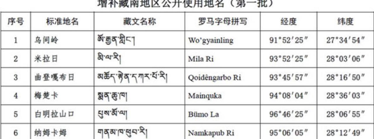
2017 list

2021 list

2023 list


Friday, April 7, 2023

The Importance of Pangchen


China has recently renamed 11 places in Arunachal Pradesh.
The first-named is Pangchen; it is an important location, mainly because the border in this sector partly depends on the traditional grazing rights between the villages of Panchen (in Tawang district of India) and Lepo (Tsona County in Lhoka/Shannan City in Tibet). The grazing rights are one of the factors, along with the watershed and customary passage and possession, which help determining a boundary.
Would Pangchen become Tibetan (or Chinese), the entire Namkha chu and Sumdorong chu valleys would automatically be part of the Tibetan/Chinese territory.
A confidential report from the Assistant Political Officer (APO) in Tawang in 1959 mentioned: “Primarily, the problem of the Tawang-Tsona boundary in the Chuthangmu [Khenzimane] sector, is of course a question of how much of the Nyamjang Chu valley is in Lebu [or Lebo] [in] Tibet territory and how much in Pangchen in India; a question which is to be decided on the basis of where the frontier traditionally has been, where the Simla Agreement of 1914 places it and what has been the de-facto position since February 1951 when regular Indian Administration was extended to the Northern Monpa area.”
The yogi, sage and builder Thangtong Gyalpo who lived during the 15th century constructed two double-cantilever iron-suspension bridges in Chaktsam (Mokto) and Drokung (Pangchen) areas of today’s Arunachal Pradesh. The Drokung Sempa (bridge) has been for century the traditional boundary for the caravans travelling between Tawang and Tsona; at that time, there was no issue between two friendly neighbours, i.e. Tibet and India. The situation is different today and with a bully in the North, each range counts and therefore the ‘dispute’ in the Khenzimane/ Sumdorung chu valley area.
The old ‘traditional’ border did not take into account the watershed principle, however the grazing rights in the area were important.
The above-quoted report explains: “Panchen of the Pang Chen Ding Druk [six] comprises Lumpo, Muchot, Kyalengteng, Kharmen, Shoksten and Zimithang [settlements] with the six Ding being Shoktsen Tui, Shoktsen Per, Shoktsen Me, Lumpo, Muchot and Kharmen (including Kyalengteng). The Ding Druk too was regarded as part of Monyul but was not under the officers stationed in Tawang/Gyankhar; its chiefs regarding themselves as autonomous and subject only to supervision by the Tsona Dzongpens [Commissioners] directly through the Tsukpa [official] of Marmang. The area used to send six representatives, generally of Thumi rank, to meetings dealing with Tawang Gompa. The McMahon Line specifies Pangchen as India territory and full administrative control has been exercised over the area by India since 1951. The total population of Pangchen is 760 with 1184 cattle and sheep.”

Zimithang/Panchen area with representative ('non-official') LAC

The Grazing Pattern
There is no need to go into the grazing pattern here, but it is clear that Pangchen plays a pivotal historical role in location of the boundary.
Today, Pangchen is known as Zimithang, due to the faster growth of this hamlet in the 1960s and the fact that it was the tactical HQ of the 4 Division during the 1962 border War with China.
Pangchen remains the traditional name of the area.
The location of Pangchen is probably the primarily reason for China to rename these 11 places in Arunachal Pradesh.

Map showing Tsona, Marmang and Zimithang/Lepo

Creations of Two New Cities
The renaming of Pangchen has also to be seen in the context of China changing the status of Tsona which has become a ‘City’ directly under the administration of the Tibet Autonomous Region (TAR) and the shifting of the HQ of the new City from Tsona to Marmang, closer to the border, north of Pangchen.
According to China News Network, on May 3, the TAR People's Government issued an announcement approved by the Central Committee of the Communist Party of China and the State Council; it abolishes the Tsona and Mainling Counties and establishes two county-level Cities with the same name (Tsona and Mainling) and the same administrative jurisdiction of two dissolved Counties. Tsona was under the jurisdiction of Shannan/Lhoka City and Mainling under Nyingchi City.
More interesting (or worrying) for India, the Government of Tsona City will be located in Marmang Monpa Ethnic Township, North of Pangchen and it will be directly administrated by the TAR Government in Lhasa.
Incidentally, Marmang is the last village where the Dalai Lama stayed before crossing to India on March 31, 1959.
This administrative change will certainly have serious implications for the border areas, particularly for the development of the infrastructure in the region. It probably means a railway line to Tsona/Marmang is not-too far in the future.
It is too early to say if the administrative changes will have military implications, but considering that everything is of dual-use on the Chinese borders, it will probably have.
For India, all this means more pressure on this area of the border, particularly in the Tawang sector, including Khenzimane, Sumdorong chu valley and Yangtse.
 

The Case of Tathong
On March 24, 1914 during the Simla Conference, there was an Exchange of Notes between the British and Tibetan Plenipotentiaries.
Henry McMahon, India’s Foreign Secretary wrote Lochen Shatra, the Tibetan Plenipotentiary (and Prime Minister): “In February last you accepted the India-Tibet frontier from the Isu Razi Pass to the Bhutan frontier, as given in the map (two sheets), of which two Copies are herewith attached, subject to the confirmation of your government and the following conditions:
(a) The Tibetan ownership in private estates on the British side of the frontier will not be disturbed.
(b) The sacred places of Tso Karpo and Tsari Sarpa fall within a day march of the British side of the frontier, they will be included in Tibetan territory and the frontier modified accordingly.
McMahon added: “The final settlement of this India-Tibet frontier will help to prevent causes of future dispute and thus cannot fail to be of great advantage to both Governments.”
The first point refers to Pachakshiri, an area today known as Menchuka.
Before 1914, the Lalus, an aristocratic family from Lhasa was getting some revenues from this place.
A scholarly research describes the area thus: “The territory known by local Memba inhabitants of Mechukha Circle as the ‘hidden land’ of Pachakshiri is located at an altitude of approximately 1900m in the north-western corner of West Siang District of Arunachal Pradesh. The wide river valley is fl by two snow-capped mountain ranges, the Damchen La to the northeast and the Shinjong La to the southwest. Memba settlements are located mainly along the sunnier northern bank of the Yargyab Chu river and are composed of various clusters of houses each bearing a common name.”
It is a fact that the Tibetans (and later on, the Chinese) never claimed any revenue from this place; In the case of the Communist Government in Tibet, it is logical as they never officially recognize the McMahon Line.
In this background, it is interesting to note that one of the renamed places by China is ‘Tato’ which has now been called ‘Tadhong’ by Beijing.
According to Census 2011, Tato village is located in Tato circle of West Siang district. It is situated 2 km away from sub-district headquarter Tato (tehsildar office) and 130 km away from district headquarter Aalo. The village has a total population of 286 peoples. There are about 50 houses in the village.
As can be seen from the map below, Tato is the gate to Menchuka/Pachakshiri.
It is not clear if the renaming is a prelude for China to claim the area.
But if they do so, it would mean an acknowledgment of the McMahon Line and it is doubtful if Beijing is ready to take this risk.

The Renamed places in Tawang sector

Friday, December 23, 2022

Why clear demarcation of LAC is a prerequisite to ensure India and China border peace

A Very Sacred Place: Arunachal Pradesh CM inaugurating a small gompa in the area
My article Why clear demarcation of LAC is a prerequisite to ensure India and China border peace appeared in Firstpost

Here is the link

Unless maps of the different perceptions are exchanged and a Line of Actual Control is agreed upon by both parties, clashes will continue, with the risk of degenerating into a larger armed conflict

It is important to understand how the northern border of India has been delineated. From the end of the 19th century, the main factor for fixing a boundary in the Himalaya, in particular with Tibet, India’s northern neighbour, has been the watershed principle.
During the Simla Conference in 1913-14, Sir Henry McMahon, India’s foreign Secretary and Lonchen Shatra, the Tibetan Prime Minister representing the 13th Dalai Lama, agreed to define the border between their nations; they signed, with seals, a map, today known as the ‘McMahon Line’, though ideally it should be the ‘McMahon-Shatra Line’.
It should be noted that Ivan Chen, the Chinese Plenipotentiary, who was present during the Conference, did not object to the presence of Lonchen Shatra on the same footing as him and India’s Foreign Secretary, and this for months.
Till 1954, when India unnecessarily agreed to the ‘Five Principles of Peaceful Co-Existence’ (Panchsheel), the Line was a peaceful frontier with Tibet; but the ink had not dried on the agreement that it became a ‘disputed’ border with China, with serious consequences for India, which continue to be seen today.
Apart from the watershed, other principles can be used to define a frontier, i.e. rivers running in the area, land tax patterns or grazing rights of the local population; this has been done in some cases.
It is a fact that during the previous centuries, no dispute had taken place with Tibet in the remote Himalayan areas; with the arrival of the People’s Liberation Army (PLA) on the border at the end of the 1950s, all this changed.

A very old dispute indeed (Chinese map of 1960)
An old dispute
While the first clash with the PLA took place in the Central Sector (Barahoti) in 1954, by mid-1959, soon after the Dalai Lama crossed to India, the Chinese started intruding in the Eastern Sector. Three places soon became ‘disputed’ (today one can count seven); these were Khenzimane, Yangtse and Longju.
It is Maj Bob Khathing, who after touring the area, demarcated the border in the Yangtse sector at the end of 1951. It was later confirmed by a detailed survey in 1954, as well as during tours of Indian officials in the following years; in Yangtse, the border was along the Kanglung Himalayan ridge.
In some cases, the border had to be slightly adjusted with the McMahon Line which, at time was imprecise due to the fast pace McMahon’s surveyors had to work before the Simla Conference and the inadequate equipment available at that time.

No fixed LAC
While China still today claims the entire Arunachal as theirs, the Line of Actual Control (LAC) remains officially undefined.
Maps of the Chinese and Indian perceptions of the LAC were exchanged in 2000 for the Central Sector (Barahoti); maps of the Northern Sector (Ladakh) came on the table for 20 minutes during a joint meeting in 2002, but were later withdrawn as China did not agree to Delhi including Gilgit-Baltistan in India’s territory.
In the case of the Eastern Sector (particularly of Tawang), maps have never been exchanged or even seen. This compounds the present confusion (often to the advantage of Beijing) and reinforces Chinese perceptions.
Sixty-two years later, the 1960 ‘disputed’ places remain ‘hotspots’ and it was expected that a flare-up could take place on any one of this places (one could also add Asaphila in the Upper Subansiri district as a possible point for a future clash).
The last flare-up took place on 9 December in Yangtse.
Indian troops were ready to retaliate
An unofficial report explains that the area under attack has “a commanding view of the ridges and tracks across the LAC deep into Tsona County in Tibet. The PLA were roughly 300 troops.”
It is far more than for their ‘routine’ intrusions.
They used melee weapons with a clear intention to harm the Indian troops holding the area: “Closely placed echelons on the lower ridges and the river valley were quickly able to reinforce the 50 troops firmly facing the PLA onslaught and reinforcements poured in from multiple directions immediately after being radioed.”
The report continues: “What started with abuses and stone pelting gradually progressed to fisticuffs and then fierce hand to hand combat where the PLA troops were overpowered and in some cases their weapons were used against them. This free for all went on until the PLA found itself losing ground with many of their troops overpowered and battered.”
The Chinese troops then started falling back on their side of the LAC.
Interestingly, they left behind some sleeping bags and other equipment which indicates that they had come to stay.

Medieval Weapons
Like in Galwan on 15 June, 2020 (it was Xi Jinping’s birthday), the PLA used melee weapons and shields. This time, the Indian soldiers were ready with the same equipment.
The reason why guns were not used is the “Agreement on the Maintenance of Peace and Tranquility along the LAC” signed by China and India in September 1993, agreeing to maintain the status quo on their mutual border pending a final solution, as well as the 1996 Agreement on Confidence-Building Measures in the Military Field” on the LAC, which mentioned: “No armed forces deployed by either side in the border areas along the line of actual control as part of their respective military strength shall be used to attack the other side, or engage in military activities that threaten the other side or undermine peace, tranquility and stability in the India-China border areas.”
Can this be considered a positive aspect during in these tense moments?

The gompa at Chumig Gyatse close to the LAC in the same sector

Development of Chumi Yangtse area
Though the Opposition would like to blame the Government for the incident, tremendous efforts have been made by Delhi in the recent years to develop the border areas in this sector and elsewhere.
It is enough to mention the opening of a new gompa (monastery); dedicated to Guru Padmasambhava, who meditated there in the 8th century, it is located a few hundred meters south of the LAC.
The Chief Minister of Arunachal Pradesh, Mr Pema Khandu himself walked to this exceptionally sacred place, blessed by 108 waterfalls, to inaugurate the gompa in July 2020.
It has to be noticed that the Chinese did not object to the construction of the gompa and its opening to Indian tourists in July 2020.

Xiaokang village north of the LAC (@NatureDesai)
Xiaokang Village as base?
A rather disturbing news that is China may have used one of the Xiaogang border villages (Beijing has built more than 600 of them, officially, ‘moderately well-off’ villages for the welfare of the local populations) as a base for their operation.
Does it mean that this string of villages on the border can just be used as garrisons for the PLA to launch attack on India?
This issue has to be followed closely by the Indian government (Army and Security agencies).

Xi Jinping abroad
President Xi Jinping was out of China (in Saudi Arabia) when the incident took place. Was he informed about the massive attack on the Indian position? Like when more than one thousand PLA troops intruded in Chumar (Ladakh) in September 2014, while Xi was visiting India?
Informed or not, such an operation needs a high level of clearance, at least from the Central Military Commission in Beijing.

End of the COVID lockdown
The Tibet Region, including the Tibetan Military District, which is responsible for the border, has been under severe (not to say brutal) COVID restrictions since the month of August; it is clear the PLA could not move earlier.
The lockdown had just been lifted when the incident in Yangtse took place and with the winter coming, rendering the logistics more complicated, Beijing had not much choice of options to show India that it has not forgotten the old disputes.
A longer stand-off would have undoubtedly been difficult for the PLA. At the same time, the CMC was probably not expecting such a stiff Indian resistance; it was therefore better for the PLA to withdraw as if nothing ‘big’ had happened.

China will not drop the ‘disputed’ area

In a press statement, Senior Colonel Long Shaohua, the spokesperson for the Western Theater Command in Chengdu claimed that it was the Indian troops who illegally crossed the LAC; he said: “The Chinese troops made a professional, normative and resolute response, bringing the on-site situation under control. Up to now, the Chinese and Indian troops have disengaged,” said the Chinese military officer.
Interestingly, he did not mention that a number of Chinese soldiers were severely injured.
The above means that the intrusions will continue, whether in Yangtse, Sumdorong chu or Asaphila (or in the Fish Tails area in Eastern Arunachal).

The status quo
India’s Defence Minister made a statement in the Parliament; he said: “On 9 December 2022, PLA (People’s Liberation Army of China) troops tried to transgress the LAC in Yangtse area of Tawang Sector and unilaterally change the status quo. The Chinese attempt was contested by our troops in a firm and resolute manner.”
Status Quo is the need of the hour, until a LAC (if not a IB) is agreed upon, the status quo should be respected by both parties.

Need to demarcate the LAC
One way forward could be to hold Ladakh-type talks for the Eastern Sector.
After 16 rounds of talks in Moldo/Chushul, some progress has been made to delineate a LAC, though in two areas (Demchok and Depsang), China has refused to vacate the areas occupied in May 2020.
Unless maps of the different perceptions are exchanged and a LAC is agreed upon by both parties, clashes will continue, with the risk of degenerating into a larger armed conflict.

Saturday, December 17, 2022

 Claude Arpi on China’s Interest in Arunachal Pradesh

My interview with Sudha Ramachandran for The Diplomat: Claude Arpi on China’s Interest in Arunachal Pradesh

Here is the link...

“For Beijing, it is a bargaining chip for an eventual ‘swap’ and the recognition by India of the occupation by China of Aksai Chin.”

Sixty years ago, on November 21, China declared a unilateral ceasefire against India bringing to an end the month-long India-China border war. Of the territory it occupied in the war, China retained control of Aksai Chin in the western sector of the disputed border but, although it took control of almost all of the North East Frontier Agency (NEFA) or today’s Arunachal Pradesh in the eastern sector, it withdrew 20 kilometers north of the McMahon Line. The pullback of Chinese forces north of the McMahon Line suggested that China was perhaps not serious about pressing its claims in the eastern sector. However, since the mid-1980s, it has robustly asserted claims over some 90,000 square kilometers of territory in India’s northeast, which roughly approximates the Indian state of Arunachal Pradesh or what China calls Southern Tibet.

In a conversation with The Diplomat’s South Asia Editor Sudha Ramachandran, author, historian and Tibetologist Claude Arpi points out that China “has not always claimed” NEFA/Arunachal and that its assertion of claims here is to gain leverage over India in a future border settlement.


When the war ended on November 21, 1962, China retained control of Aksai Chin but pulled back from India’s Northeast. Why?

The two sectors are historically very different.
To understand, it is necessary to go back to the Bandung Conference in 1955. An apparently moderate Zhou Enlai [China’s premier] convinced [Indian Prime Minister] Nehru of the “sincerity” of the Chinese Communist rulers. Writing about his encounter with Zhou at the Conference, Nehru said: “When asked if he wanted to push communism into Tibet, Chou En-lai [Zhou Enlai] laughed and said that there could be no such question as Tibet was very far indeed from communism. It would be thoroughly impracticable to try to establish a communist regime in Tibet and the Chinese Government had no such wish.”
A few days later, the Indian prime minister told the Indian foreign secretary about a remark by the Chinese premier on the McMahon Line: “Although [Zhou] thought that this line, established by British imperialists, was not fair, nevertheless, because it was an accomplished fact and because of the friendly relations which existed between China and the countries concerned, namely, India and Burma, the Chinese Government were of the opinion that they should give recognition to this McMahon Line.”
Five years later, Zhou Enlai visited Delhi and had long talks with Nehru. In an informal encounter with Indian Defense Minister V.K. Krishna Menon,  Zhou explained that in the Western Sector (Aksai Chin) there had never been any delimitation and only an old treaty (of 1842), which did not mention any area; Aksai Chin, he affirmed, had always been part of Sinkiang (today’s Xinjiang) and the [Aksai Chin] road built by China (without India realizing it) was on Chinese territory.
Later, Zhou tested the ground for a “swap”: India would acknowledge Aksai Chin as Chinese and Beijing would recognize the North East Frontier Agency (NEFA or today’s Arunachal Pradesh) as Indian.
One has to understand that for Beijing Aksai Chin was strategically far more important than the NEFA. The road built in the early 1950s linked the two newly-acquired provinces of the People’s Republic of China, Xinjiang and Tibet.
Therefore, for Mao and his colleagues, there was never a question to return Aksai Chin to India. Further, Beijing has argued that the Communists started surveying the Aksai Chin road in 1952, the construction began in 1954/55 and it was inaugurated in 1957; during all these years India did not complain. Delhi only started objecting to Beijing in 1958. For the Chinese leadership, it was proof that the area never belonged to India.
On the opposite end, NEFA saw very few incursions from the Chinese troops south of the McMahon Line (the first one took place in Longju in August 1959). An early incursion had happened in the Walong sector in 1910, but the Chinese troops quickly returned to their barracks north of the watershed.
All this shows that both areas do not have the same strategic importance for the Chinese.
It is probably why China decided to withdraw from the NEFA in 1962.
The eastern sector of the India-China border, depicting the disputed area of the Indian state of Arunachal Pradesh, which China claims as Southern Tibet. Map by the U.S. Central Intelligence Agency.

Chinese claims in NEFA in 1960

Since the mid-1980s, China has been reasserting rights over Arunachal Pradesh. Why the renewed interest in this territory?

During the last few months, Beijing’s propaganda has reiterated that the entire Arunachal Pradesh is part of “Southern Tibet.”
On November 10, Xinhua published a news item: “A 5.6-magnitude earthquake jolted Medog County in Nyingchi City, southwest China’s Tibet Autonomous Region, at 1:01 pm, Beijing Time, according to the China Earthquake Networks Center (CENC). The epicenter was monitored at 28.35 degrees north latitude and 94.48 degrees east longitude, with a depth of 10 km, the CENC said.”
The area mentioned is near Likabali in Arunachal Pradesh.
In January 2022, Global Times announced new names of 15 places in Arunachal Pradesh, given with precise coordinates. Eight were residential areas, four were mountains, two were rivers, and one was a mountain pass (Sela). It was the second batch of so-called standardized names of places published by the Chinese government; the first batch of the so-called standardized names of six places in Arunachal was released in 2017. This is part of the propaganda to assert China’s claims.
For Beijing, it is a bargaining chip for an eventual “swap” and the recognition by India of the occupation by China of Aksai Chin.
It is interesting to look into the rationale of the Chinese claim over NEFA/Arunachal. The origin is linked to the creation of the Xikang province. In the 1930s, a Chinese scholar, Ren Naiqiang was encouraged by Liu Wenhui, the governor of Xikang, to produce a map of the area. Though the Chinese had never set foot in the area, the new map included NEFA in the new Chinese province.
In 1939, the Nationalist Government formally established a new province called Xikang (more or less corresponding to Tibet’s Kham province).
At the end of 1949, Ren Naiqiang met Marshal He Long, one of the senior-most generals of the People’s Liberation Army (PLA), and explained why his map was dependable; the Marshal was convinced and ordered the distribution of copies. On January 10, 1950, He Long sent a report to Mao Zedong strongly recommending that Ren’s map should be accepted and circulated amongst the PLA. It is after this episode that Beijing started claiming NEFA as Chinese. This shows that China has not always claimed NEFA.

Why is Tawang important to China?

Maj Bob Khathing in February 1951 in Tawang
China has never officially accepted the existence of the Tibetan exile government. If India would return Tawang to China (including the monastery), it would be a denial by Delhi that the 1914 Indo-Tibet border agreement and the McMahon Line ever existed.
The fact remains that the border agreement of March 1914 had been signed with official seals by the Foreign Secretary of India (Sir Henry McMahon) and the Prime Minister of Tibet (Lochen Shatra).
It is also true that monastic taxes in the area were being collected by Tibetan officials till February 1951, when the expedition led by Maj. Bob Khathing took over the Tawang administration.
But taxes paid by a monastery do not amount to ownership certificates. Several monasteries in the Indian Himalaya have been affiliated with large monasteries in Tibet; it does not mean that these monasteries belong to China.
Another factor is that the Sixth Dalai Lama, Tsangyang Gyatso, was born in Urgyeling, south of Tawang. It is another pretext for China to claim the area. But the fact that a religious leader is born on a foreign territory is not legally considered a valid argument to claim ownership of the country (or the area where the leader is born).
Not often mentioned are the bitter relations existing between the Monpas and the Tibetans till the arrival of Major Khathing. In 1938, when Captain Lightfoot, the Assistant Political Officer (APO) in Balipara (Assam) visited Tawang, he noted: “Our visit raised hopes that they might be relieved of the Tibetan yoke but there was grave uneasiness at our departure lest they should be punished for the help they had given us… Tibetan domination is loathed by the Monpaas and is intolerable by any civilized standards.”
The APO observed that forced labor and extortion of supplies, failure by the Tibetans to protect the Monpas, payment of tribute at rates bearing no relation to the ability of villagers to pay, and finally a brutal and unspeakably corrupt judicial system made the local Monpas believe that they were “liberated” by Major Khathing and his Assam Rifles from the Tibetan yoke in 1951.
India has improved connectivity and military infrastructure along the LAC in the eastern sector. How does it match up to infrastructure on the Chinese side?
Because of the nature of the terrain, India will never match China in terms of infrastructure, but since a few years, the mindset of the government has changed and serious efforts have been made, if not to at least “catch up” to have a decent infrastructure to the border districts/circles in India.
To give a few examples, Hollongi Greenfield Airport, also called Donyi Polo Airport, near Itanagar, serving Arunachal’s capital has recently been opened.
On November 2, a Dornier D-28 aircraft landed at the Ziro Advanced Landing Ground (ALG) in the Lower Subansiri district; commercial operations are expected to start soon. The 17-seater aircraft was operated by Alliance Air. ATR-72 and Dornier D-228 are already operational at Pasighat (Assam) and Tezu airports.
Arunachal Pradesh now has four airports (Itanagar, Ziro, Pasighat, and Tezu) and nine ALGs at Aalo, Mechuka, Pasighat, Tawang Air Force Station, Tuting, Vijaynagar, Walong, Ziro, and Daporijo. Several helipads have also been built near the McMahon Line.
While most of the existing roads have been improved, for example between Tezpur in Assam and Tawang, many new ones closer to the Line of Actual Control (LAC) have been built. Further, the traffic on the Bomdila-Tawang road will greatly improve with the opening of the tunnel under the Sela pass at the end of the year.
Even the last post in the Upper Subansiri district (in Maja), will soon be connected.
But first and foremost, what has changed is the mindset. A few years ago, one often heard: “We don’t need good roads, if the Chinese come again, they will break their vehicles on our poorly-maintained tracks.”
Today, the Arunachal Pradesh government as well as the Indian Army understand the necessity of dual-use infrastructure, not only for defending the border, but also helping the remote villages to survive.

Could you throw light on India’s “Vibrant Villages” scheme? What underlies the development of these villages?

To understand the “Vibrant Villages” scheme one has to look at the other side of the McMahon Line.
The Sixth Tibet Work Forum (TWF), held in Beijing on August 24 and 25, 2015 was a turning point for the Tibetan plateau. Tibet Work Forums are large meetings called every 5 to 10 years to discuss the Chinese Communist Party’s Tibet policies. They are attended by all the members of the powerful Politburo Standing Committee, members of the Central Committee, or senior PLA generals. The Sixth Forum decided to tackle poverty and develop Xiaokang (“moderately well-off”) villages on the plateau.
In 2017, soon after the conclusion of the 19th Congress, President Xi Jinping wrote a letter to two young Tibetan herders who had written to him introducing their village, Yume, north of the Upper Subansiri district. Xi “encouraged a herding family in Lhuntse County …to set down roots in the border area, safeguard the Chinese territory and develop their hometown.” Soon after, Yume became a model village for more than 600 Xiaokang villages, a large number located close to the Indian border.
The “Vibrant Villages” is a response to hundreds of Xiaokang villages, which have mushroomed on the Tibetan plateau. In India, they are also meant to tackle another genuine problem: large-scale migration from the border areas.
According to the Central Government’s announcement, India plans to open the villages along the Chinese border for tourists.: “The activities will include construction of village infrastructure, housing, tourist centers, road connectivity, provisioning of decentralized renewable energy, direct-to-home access for Doordarshan and educational channels, and support for livelihood generation.”
The government’s objectives are clear: “to enhance infrastructure in villages along India’s border with China, in states like Himachal Pradesh, Uttarakhand, and Arunachal Pradesh.”
Like in Tibet, the scheme is based on the premise that the border areas will be opened to tourists, which will provide the economic backbone for the scheme. Several measures to remove/relax the Inner Line Permit system and other restrictions have already been taken, in Ladakh in particular.
If successful, it should give a boost to the local economy and benefit the populations living in these remote, largely inaccessible border areas. It will also enhance the defense preparedness of the Indian defense forces, which can use the newly created infrastructure

Thursday, December 15, 2022

We are well prepared for any eventualities: Pema Khandu

Arunachal Pradesh Chief Minister Pema Khandu pays tribute to Veer Jawans
of the 5 Assam Rifles at the Chhetri War Memorial
near Tulung La pass at the India-Tibet border
 The first part of my interview with Pema Khandu, the Chief Minister of Arunachal Pradesh 'We are well prepared for any eventualities' appeared in Rediff.com

'Guarding the borders in extreme weather conditions is not easy and most people don't realise it is a very tough job.'

In April 2011, Dorjee Khandu, the chief minister of Arunachal Pradesh, died in tragic circumstances in a helicopter crash.
Soon after, his elder son Pema succeeded him as the MLA of Mukto in Tawang district; he was then only 32 years old.
Five years later, on July 17, 2016, after a long period of confusion in the state, Pema Khandu took oath as the chief minister; soon after, he joined the Bharatiya Janata Party.
During the 2019 legislative assembly elections, Khandu won a landslide victory with 41 seats out of 60 for the BJP alone.
Under Khandu's leadership, the border state found badly needed stability which helped putting Arunachal Pradesh on fast track development, while preserving its own genius.
At a time when China social media is buzzing with threats of military action against Arunachal (with various verified or unverified handles releasing videos and photos of People's Liberation Army troops training close to the Indian border), Arunachal Pradesh's dynamic 42-year-old chief minister answers Claude Arpi's questions.
He speaks of the 'Philosophy of Arunachal', his visits to the troops posted at the LAC, but also of the development of the infrastructure, his vision for 'Low Volume High Value' (including spiritual) tourism and the importance of ecology for the entire Himalaya.
He concludes by putting on record that Arunachal Pradesh does not share any direct border with China, but only with Tibet; it is indeed the best answer to Beijing, who without any historical basis, continues to claim the entire Indian State.


The first of an exclusive two-part interview:

For decades the 'Philosophy of NEFA' has been the guiding policy for what is today Arunachal Pradesh (as well as the North-East in general).
It may have helped to preserve the tribal culture but it did not take care of the borders when India was attacked.
Do you have today a 'Philosophy of Arunachal'? If yes, can you elaborate?

The 'Philosophy of NEFA' propounded by Verrier Elwin included facilitating the local population to develop on their own genius, respecting tribal rights in land and forests and respecting the social and cultural institutions.
These contours are honoured even today.
But there is a significant change in the Government of India's approach to the northeast region, where earlier a Union government's minister coming even to Guwahati used to become news.
Today we have five ministers in the Union council of ministers from the northeast region, including a Cabinet minister from Arunachal Pradesh.
Every month we have visits from the Union government bringing in some important development scheme for the people.
This signifies a major shift in the mindset and the confidence of New India under the leadership of Prime Minister Narendra Modi.
Developing our border areas and securing territorial integrity is the priority of our government both at the Centre and state.
The 'Philosophy of Arunachal Pradesh' is the same as the 'Philosophy of New India' which comes with the awareness of where we stand today and what we wish to achieve.
We care about the last person standing in the queue and our aspirations are not limited by our past.

Chief Minister Pema Khandu with Indian Army jawans on the occasion
of 22nd Kargil Vijay Diwas in Tawang

The media has lately reported your visits to forward posts and your interactions with jawans and officers.
Tell us about your motivations. And also about the importance of these visits. Should it be emulated by other CMs in other border states?


My father served in the Indian Army and having been born and lived most part of my life in the border region of Tawang district in India, I have seen the life of our security forces very closely.
Guarding the borders in extreme weather conditions is not easy and most people don't realise it is a very tough job.
By visiting our forces in the forward posts, I am only paying a humble tribute to them for the immense sacrifice they are making for our great nation.
I know many other leaders in our country who too visit border regions.
Visiting my uniformed brothers in forward posts is a very personal motivation and if other leaders and common people in other states too emulate it, would be a wonderful gesture.
I welcome fellow countrymen to come and visit forward posts of Arunachal Pradesh and understand the tough life of security forces and common citizens of the state.

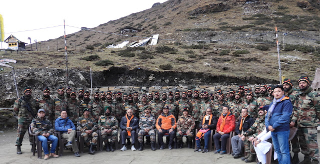
Chief Minister Pema Khandu at Chuna with Indian Army soldiers.

Many in India believe that one should change the narrative of the 1962 War with China, in the sense that India did well in many areas (in the Walong sector for example). Do you plan to do something to change this 'defeat' narrative?

1962 is in the past, We have learned many things and is well prepared for any future eventualities.
I fully agree that the Walong sector triumph of our armed forces is under reported.
No matter what, the people of Arunachal Pradesh stand resolutely behind the armed forces.
Yes, We are developing the sites of the 1962 war as memorials in Tawang as well as the Walong area, it is an emotional feeling just to be present at those sites and experience the valour of the soldiers who fought then.
All these will tell the story, as it happened.

Chief Minister Pema Khandu with movie star Salman Khan.

China is building infrastructure on the other side of the border. For example, a new large airport is coming up in Lhuntse Dzong in Lhoka (Shannan); the train has reached Nyingchi, and the G219 (Aksai Chin road) to Tsari area and all along India's northern border?
What are you doing to counter this? What are Arunachal Pradesh's achievements in this field.


Our Prime Minister Narendra Modiji in the speech at the UN General Assembly had said, 'Democracy can deliver, Democracy has delivered.'
People of India and Arunachal Pradesh don't want to emulate any 'model of development' that tramples the liberty and culture of the local people.
Indian democracy isn't a 'one size fits all' model.
We are working towards providing amenities to the people in the border areas.
We are working aggressively to expand our road, rail and air network, improving communication networks and developing infrastructure to improve health and education status of our people.
The case in point is the Bogibheel bridge and the Dhola-Sadiya bridge which were pending for decades, it used to take hours to cross the Brahmaputra then.
Today because of the initiative of Prime Minister Narendra Modi, the bridges got completed in record pace and can be crossed in minutes.
We will get our first airport in 2022 in Itanagar whose foundation was laid in 2019.
The Trans Arunachal Highway (about 1,600 km) is almost under completion and the Sela tunnel will make year-round travel to Tawang easy.
Eight new ALGs have become functional and around 1,000 new 4G towers are being installed in addition to the ongoing optical fibre projects to enhance digital connectivity.
All foothill areas will be connected with a rail network soon.
Surveys are being conducted to bring rail connectivity to Bame and high altitude areas like Tawang as well.
The list is long, yet our model of Compassionate Governance will have NO Match.

Sunday, January 2, 2022

What about Patia-la?

Did Beijing ask the local population if they want to be part of China?

Since 1984, the Chinese and Bhutanese officials have been meeting to discuss their common border. 

The Bhutanese negotiators are usually bullied by the big ‘Northern Neighbour’ (the Bhutanese prefer to call China thus).
A few years ago, in the course of a 'discussion', the Chinese side gave a long presentation about the names of the places which, according to them, proved that Bhutan occupied some Chinese territory at several locations. 

They started arguing the ‘la’ was a Chinese word (it means ‘pass’ in Tibetan and Bhutanese, not in Chinese).  Even after the Bhutanese negotiators told their Chinese counterparts that it was not a Chinese name, the latter continued to insist.
It is then that a senior smart Bhutanese official interrupted the Chinese argument and asked: “What at Patia-la? Is it a Chinese place?”
The Chinese were so much taken by surprise that they kept quiet …at least for some time.
This anecdote came to mind when I read that Beijing had released the second batch of ‘new’ names for places in Arunachal Pradesh.
On December 30, the Ministry of Civil Affairs in Beijing announced that it had “standardized in Chinese characters, Tibetan and Roman alphabet the names of 15 places in Zangnan [they now call thus the southern part of Xizang or Tibet], in accordance with regulations on geographical names issued by the State Council, China's cabinet.”
'Zangnan' is probably an abbreviation of (Xi)Zang = Tibet and 'Nan' (south in Mandarin).
China has never used this term before.
Why Beijing has used a Chinese abbreviation for the area and Tibetan names for the 15 locations is not clear.

The 15 Places
According to The Global Times, among the official names of the 15 places, which were given with precise coordinates, eight were residential areas, four were mountains, two were rivers and one is a mountain pass (Sela).
It was the second batch of so-called standardized names of places published by the ministry; the first batch of the so-called standardized names of six places in was released in 2017 (see article below).
Contrary to what the Indian media wrongly mentioned, the names are not ‘invented’ names; they are transcription of the Tibetan names for these 15 areas.
It is far more serious than ‘invented names’ as by ‘proving’ that these places had Tibetan names, China can come to the easy conclusion that they have been Tibetan places and therefore Chinese.
The argument is tenuous, as it is often the case, but it does not stop China from using it.
It however gives a clear message to India: whatever has been Tibetan (or even have a Tibetan name) belongs to China.
One day, places in Ladakh, Sikkim or Kinnaur will thus be claimed.
Lian Xiangmin, from the China Tibetology Research Center in Beijing, explained to The Global Times that “it is part of a national effort to standardize the management of place names. The places have existed for hundreds of years.”
Interestingly, as mentioned earlier on this blog, the claim on NEFA as being part of the Chinese territory dates only from the end of 1930s, when the newly-created Xikang Province engulfed some these areas of the North-East.
Lian said: “It is a legitimate move and China's sovereign right to give them standardized names. More standardized place names in the region will be announced in the future.”
Another so-called expert, Zhang Yongpan, from the Institute of Chinese Borderland Studies under the Chinese Academy of Social Sciences said that these areas were named by the central and local (Tibetan) governments “throughout history, as well as ethnic groups such as the Tibetan, Lhoba, and Monba who have long lived in the region.”
Historically, it is again entirely wrong.
The move is apparently part of the implementation of the new the Land Border Law, which has come into effect on January 1, 2022.
The Global Times explained: “The eight residential places in the second batch are Sêngkêzong [Senge Dzong] and Daglungzong [Taklung Dzong] in Cona [Tsona] County of Shannan [Lhoka] Prefecture, Mani'gang [Manigong], Duding [Tuting]and Migpain [Migpan] in Medog [Metok] County of Nyingchi [Nyingtri], Goling, Damba [Tampa] in Zayu [Zayul] County of Nyingchi, and Mêjag [Mechag or Maja] in Lhunze [Lhuntse] County of Shannan Prefecture. ‘The four mountains are Wamo Ri, Dêu [Deu] Ri, Lhünzhub [Lhungrup] Ri and Kunmingxingzê [Guming Shingtse] Feng. The two rivers are Xênyogmo He [Syiom] and Dulain [Tulan] He, and the mountain pass is named Sê La [Sela], in Cona [Tsona] County.”
This chart shows that the ‘new’ names derive from Tibetan names (click to enlarge).

Why this mixture of different places is not clear.
But what is worrying is that Maja, south of Longju, where China built a new village on Indian territory a few months is included.
So is Tuting (Duding) in the Upper Siang district is also mentioned.
The time has perhaps come for India to reassert its claim on Minsar, the Indian principality near Mt Kailash.

My 2017 article...


China has announced 'official standardised' names for six places in Arunachal Pradesh.
It is a childish reaction to the Dalai Lama's visit to the State earlier this month.
The Chinese media said that Beijing's objective was to reaffirm China's claim over Arunachal, 'South Tibet' for the Chinese.
A few days earlier, Beijing had started naming ‘Tawang’ as ‘Dawang’, according to its pin yin spelling.
The Global Times reported: "China's ministry of civil affairs announced on April 14 that it had standardised in Chinese characters, Tibetan and Roman alphabet the names of six places in 'South Tibet', which India calls 'Arunachal Pradesh', in accordance with the regulations of the central government."
The official names of the six places (transcribed in Roman alphabet) are:

  • Wo'gyainling,
  • Mila Ri,
  • Qoidengarbo Ri,
  • Mainquka,
  • Bumo La and
  • Namkapub Ri.
Let us have a look where these places are located.

Wo'gyainling is the new spelling for Urgyeling, the birthplace of Tsangyang Gyaltso, the Sixth Dalai Lama, a few kilometers south of Tawang Town.
One understands the reasons why China is so attached to the place. Beijing is not ready to accept that a Dalai Lama could be born outside Tibet (China).

The second place is Mila Ri.
It is a lake known as Mila Nagula.
Mila Ri is one of the ridges above the lake.
‘Ri’ means ‘mountain’ or ‘ridge’ in Tibetan/Monpa.
It is situated near the famous 'Madhuri' Lake, north of Tawang and South of Bumla. The place is mentioned in the 1962 War records.


The third place is Qoidengarbo Ri, for 'Chorten Karpo’ or ‘White Stupa’.
It probably refers to Gorsam Chorten, the only large white stupa in the area (and the largest in Arunachal).
It is not far from Ziminthang, the tactical HQ of the 4 Infantry Division during the 1962 War.
The name may refer to one of the ridges around the stupa.


Mainquka is Menchuka in West Siang.
China is not happy that India recently landed a C17 Hercules transport aircraft in the area. Watch the video.
I have often written on Menchuka (or Mechuka, alternative spelling) on this blog.
Menchuka was occupied by the Chinese in October/November 1962.


Bumo La is the border post of Bumla where the Indian Army and the Chinese PLA meet several times a year.
Incidentally 'bumo' means 'girl' in Tibetan/Monpa.


Namkapub Ri is probably link to Namkha chu river, the theater of the first Chinese attack in 1962.
It is one of the ridges above the river (Hathungla?).


By naming these six places, Beijing probably wants to remind India of the 1962 War and the fact that the Dalai Lama ‘belongs to China’.
But renaming names is not new.
It has been done by all colonizers.
In this case, it will be difficult for China to convince the local populations to join them under the Communist banner.

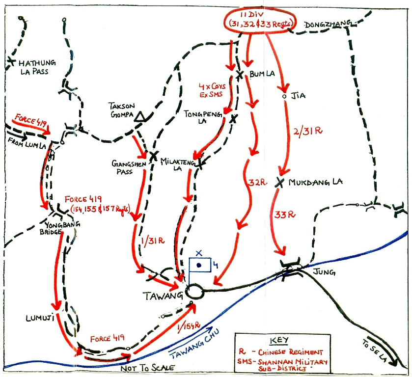
Below a map showing the Chinese advances toward Tawang on October 23-24 1962 (courtesy: Maj Gen PJS Sandhu, retd) from the book 1962: A view from the Other Side of the Hill published by United Service Institution of India.
One can see Milakteng (Mila Ri) and Bumla. The stupa is not marked on the map.
Map by Brig John Dalvi, 7 Infantry Brigade commander in October 1962
The Gorsam Chorten (Stupa) and the Namkha Chu are shown.


Thursday, December 16, 2021

Indianness of Arunachal is not to be proven to anyone: Pema Khandu

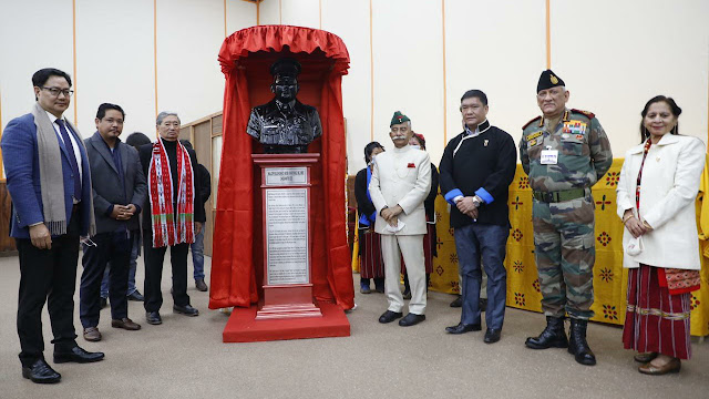
Inaugurating Maj Bob Khating Memorial with the Governor
and the CDS, Gen Bipin Rawat in Tawang and Kiren Rijiju (right)

This is the second part of my interview with Pema Khandu, the Chief Minister of Arunachal Pradesh, Indianness of Arunachal is not to be proven to anyone, the interview was published by Rediff.com.

Here is the link...

'Our love for our great nation -- Bharat is second to none and our patriotism towards our motherland -- India is for the entire nation to emulate.'

In April 2011, Dorjee Khandu, the chief minister of Arunachal Pradesh, died in tragic circumstances in a helicopter crash.
Soon after, his elder son Pema succeeded him as the MLA of Mukto in Tawang district; he was then only 32 years old.
Five years later, on July 17, 2016, after a long period of confusion in the state, Pema Khandu took oath as the chief minister; soon after, he joined the Bharatiya Janata Party.
During the 2019 legislative assembly elections, Khandu won a landslide victory with 41 seats out of 60 for the BJP alone.
Under Khandu's leadership, the border state found badly needed stability which helped putting Arunachal Pradesh on fast track development, while preserving its own genius.
At a time when China social media is buzzing with threats of military action against Arunachal (with various verified or unverified handles releasing videos and photos of People's Liberation Army troops training close to the Indian border), Arunachal Pradesh's dynamic 42-year-old chief minister answers Claude Arpi's questions.
Sponsored

The final segment of an exclusive two-part interview:

China is said to have built more than 600 'model' villages on the border (most of them north of Arunachal). According to Beijing's propaganda, there are two objectives: Poverty alleviation and defence of the border.

Arunachal Pradesh is home to patriotic 26 major tribes and over 100 sub tribes, we are a thriving society where people elect their leaders democratically by elections.
We are empowering our border regions to develop in conjunction with their culture and traditions.
We are running programmes where people decide to stay back out of free will in the border areas because the land, rivers and forests are sacred to us.
We are committed to protecting our environment and preserving it.
This is our model and it is an open source model. Anyone can use this model.

You have been trying to develop Arunachal as a sustainable tourism destination. Does the Bengal Eastern Frontier Regulation, 1873, known as the Inner Line Permit hamper your efforts?
Have you envisaged a sort of 'digital' pass which could remove the idea that Arunachal Pradesh is different from other states in India?


Inner Line Permit is not a restrictive regulation that hampers tourism but meant to conserve the culture and traditions of the indigenous tribal societies.
As the chief minister of the state, I have been talking of 'High Value Low Volume' tourism which is sustainable as well as provides employment to our youth.
We have made the process of granting the Inner Line Permit digital and is seamless.

Many places have been visited by Guru Padmasambhava, Guru Nanak or other saints/lamas/yogis. Do you envisage developing 'spiritual' tourism in Arunachal?

Not many are aware but Guru Padmasambhava and Guru Nanak Dev have travelled through the state.
Arunachal Pradesh is also the land of indigenous faiths and we have developed a temple in Pasighat for indigenous faiths.
Tawang has the largest monastery in the country and second largest in the world after the Lhasa monastery.
There is a beautiful Golden Pagoda in Namsai area of the state.
Malinithan has ancient temples in the Likabali area of the state.
We have the famous Parashuram Kund and a famous Shiva temple in the Ziro region.
There are various Christian denominations and some beautiful churches too in the state.

In March 2021 during the last National's People Congress, a draft of China's 14th Five-Year Plan was presented; it included the first phase for the construction of a mega hydropower plant or plants (thrice the size of the Three Gorges Dam) in the Great Bend area.
In view of the fragility of the Pemakoe area (seismic, landslide, biodiversity, etc) as well as the sacredness of the place, can something be done to put this project on hold?


The Government of India is taking all appropriate actions to secure the interests of her people and terrain of the region.

In 2009 at the conclusion of a two-day meet on environment, the chief ministers of five Himalayan states signed the Simla Declaration.
Do you think that this type of initiative should be repeated?
Would you take the initiative for a greater 'Himalayan' unity as far as environment and culture are concerned?


I have always been advocating that the Mountain States have their unique strength and challenges.
Therefore, the development model of this fragile ecology need a different treatment to take forward development of the area.
The Himalayan landscape and her people's culture calls for unified and sustainable call for development.
We are mindful of taking these aspects very seriously, while taking up our development goals.

'Migration' towards the big cities seems to be a serious problem for your state. Can you elaborate? How are you planning to tackle this issue?

Yes, it is a universal phenomenon. Everyone wants to look for better avenues for a comfortable life for them and their families.
This is also true in Arunachal Pradesh.
While the same is NOT discouraged, the government's endeavour is to provide all the basic facilities of health, education, housing etc in situ to encourage our people to live in the respective villages and ensure they are NOT uprooted from their roots.
We are also empowering our villages in the true sense in which Mahatma Gandhi talked of Gram Swaraj.
We have recently conducted the panchayat elections in the state and are determined to provide the 3Fs -- Funds, Functions and Functionaries to the villages.
There are still too many remote villages in Arunachal Pradesh, with hardly any 'modern' facilities (school, dispensaries, communications, etc)? How do you plan to remedy this?
As I mentioned, we are late starter in our development journey.
However, in the last 6 years, we have added many 'modern' facilities in remote villages -- Saubhagya for electrification, PMAY for housing, UJJAWALA for cooking gas and Jal Jeevan Mission to take potable drinking water to each household to name a few.
The government of Arunachal Pradesh conducted a programme called Sarkar Aapke Dwar or 'Government at your Doorstep' to take essential government schemes to extremely remote villages and benefitted over 4 lakh people.
Yes, we have still a lot of distance to cover and we are working towards this goal.

How does it feel to rule over a state claimed by another country? Do you think that more historical research could highlight the fact that Arunachal has never been part of China?

The Indianness of the People of Arunachal Pradesh is NOT to be proven to anyone.
Our love for our great nation -- Bharat is second to none and our patriotism towards our motherland -- India is for the entire nation to emulate.
Further to state on record that Arunachal Pradesh does not share any direct border with China, but it has a border with Tibet.