Showing posts with label Menchuka. Show all posts

Sunday, January 2, 2022

What about Patia-la?

Did Beijing ask the local population if they want to be part of China?

Since 1984, the Chinese and Bhutanese officials have been meeting to discuss their common border. 

The Bhutanese negotiators are usually bullied by the big ‘Northern Neighbour’ (the Bhutanese prefer to call China thus).
A few years ago, in the course of a 'discussion', the Chinese side gave a long presentation about the names of the places which, according to them, proved that Bhutan occupied some Chinese territory at several locations. 

They started arguing the ‘la’ was a Chinese word (it means ‘pass’ in Tibetan and Bhutanese, not in Chinese).  Even after the Bhutanese negotiators told their Chinese counterparts that it was not a Chinese name, the latter continued to insist.
It is then that a senior smart Bhutanese official interrupted the Chinese argument and asked: “What at Patia-la? Is it a Chinese place?”
The Chinese were so much taken by surprise that they kept quiet …at least for some time.
This anecdote came to mind when I read that Beijing had released the second batch of ‘new’ names for places in Arunachal Pradesh.
On December 30, the Ministry of Civil Affairs in Beijing announced that it had “standardized in Chinese characters, Tibetan and Roman alphabet the names of 15 places in Zangnan [they now call thus the southern part of Xizang or Tibet], in accordance with regulations on geographical names issued by the State Council, China's cabinet.”
'Zangnan' is probably an abbreviation of (Xi)Zang = Tibet and 'Nan' (south in Mandarin).
China has never used this term before.
Why Beijing has used a Chinese abbreviation for the area and Tibetan names for the 15 locations is not clear.

The 15 Places
According to The Global Times, among the official names of the 15 places, which were given with precise coordinates, eight were residential areas, four were mountains, two were rivers and one is a mountain pass (Sela).
It was the second batch of so-called standardized names of places published by the ministry; the first batch of the so-called standardized names of six places in was released in 2017 (see article below).
Contrary to what the Indian media wrongly mentioned, the names are not ‘invented’ names; they are transcription of the Tibetan names for these 15 areas.
It is far more serious than ‘invented names’ as by ‘proving’ that these places had Tibetan names, China can come to the easy conclusion that they have been Tibetan places and therefore Chinese.
The argument is tenuous, as it is often the case, but it does not stop China from using it.
It however gives a clear message to India: whatever has been Tibetan (or even have a Tibetan name) belongs to China.
One day, places in Ladakh, Sikkim or Kinnaur will thus be claimed.
Lian Xiangmin, from the China Tibetology Research Center in Beijing, explained to The Global Times that “it is part of a national effort to standardize the management of place names. The places have existed for hundreds of years.”
Interestingly, as mentioned earlier on this blog, the claim on NEFA as being part of the Chinese territory dates only from the end of 1930s, when the newly-created Xikang Province engulfed some these areas of the North-East.
Lian said: “It is a legitimate move and China's sovereign right to give them standardized names. More standardized place names in the region will be announced in the future.”
Another so-called expert, Zhang Yongpan, from the Institute of Chinese Borderland Studies under the Chinese Academy of Social Sciences said that these areas were named by the central and local (Tibetan) governments “throughout history, as well as ethnic groups such as the Tibetan, Lhoba, and Monba who have long lived in the region.”
Historically, it is again entirely wrong.
The move is apparently part of the implementation of the new the Land Border Law, which has come into effect on January 1, 2022.
The Global Times explained: “The eight residential places in the second batch are Sêngkêzong [Senge Dzong] and Daglungzong [Taklung Dzong] in Cona [Tsona] County of Shannan [Lhoka] Prefecture, Mani'gang [Manigong], Duding [Tuting]and Migpain [Migpan] in Medog [Metok] County of Nyingchi [Nyingtri], Goling, Damba [Tampa] in Zayu [Zayul] County of Nyingchi, and Mêjag [Mechag or Maja] in Lhunze [Lhuntse] County of Shannan Prefecture. ‘The four mountains are Wamo Ri, Dêu [Deu] Ri, Lhünzhub [Lhungrup] Ri and Kunmingxingzê [Guming Shingtse] Feng. The two rivers are Xênyogmo He [Syiom] and Dulain [Tulan] He, and the mountain pass is named Sê La [Sela], in Cona [Tsona] County.”
This chart shows that the ‘new’ names derive from Tibetan names (click to enlarge).

Why this mixture of different places is not clear.
But what is worrying is that Maja, south of Longju, where China built a new village on Indian territory a few months is included.
So is Tuting (Duding) in the Upper Siang district is also mentioned.
The time has perhaps come for India to reassert its claim on Minsar, the Indian principality near Mt Kailash.

My 2017 article...


China has announced 'official standardised' names for six places in Arunachal Pradesh.
It is a childish reaction to the Dalai Lama's visit to the State earlier this month.
The Chinese media said that Beijing's objective was to reaffirm China's claim over Arunachal, 'South Tibet' for the Chinese.
A few days earlier, Beijing had started naming ‘Tawang’ as ‘Dawang’, according to its pin yin spelling.
The Global Times reported: "China's ministry of civil affairs announced on April 14 that it had standardised in Chinese characters, Tibetan and Roman alphabet the names of six places in 'South Tibet', which India calls 'Arunachal Pradesh', in accordance with the regulations of the central government."
The official names of the six places (transcribed in Roman alphabet) are:

  • Wo'gyainling,
  • Mila Ri,
  • Qoidengarbo Ri,
  • Mainquka,
  • Bumo La and
  • Namkapub Ri.
Let us have a look where these places are located.

Wo'gyainling is the new spelling for Urgyeling, the birthplace of Tsangyang Gyaltso, the Sixth Dalai Lama, a few kilometers south of Tawang Town.
One understands the reasons why China is so attached to the place. Beijing is not ready to accept that a Dalai Lama could be born outside Tibet (China).

The second place is Mila Ri.
It is a lake known as Mila Nagula.
Mila Ri is one of the ridges above the lake.
‘Ri’ means ‘mountain’ or ‘ridge’ in Tibetan/Monpa.
It is situated near the famous 'Madhuri' Lake, north of Tawang and South of Bumla. The place is mentioned in the 1962 War records.


The third place is Qoidengarbo Ri, for 'Chorten Karpo’ or ‘White Stupa’.
It probably refers to Gorsam Chorten, the only large white stupa in the area (and the largest in Arunachal).
It is not far from Ziminthang, the tactical HQ of the 4 Infantry Division during the 1962 War.
The name may refer to one of the ridges around the stupa.


Mainquka is Menchuka in West Siang.
China is not happy that India recently landed a C17 Hercules transport aircraft in the area. Watch the video.
I have often written on Menchuka (or Mechuka, alternative spelling) on this blog.
Menchuka was occupied by the Chinese in October/November 1962.


Bumo La is the border post of Bumla where the Indian Army and the Chinese PLA meet several times a year.
Incidentally 'bumo' means 'girl' in Tibetan/Monpa.


Namkapub Ri is probably link to Namkha chu river, the theater of the first Chinese attack in 1962.
It is one of the ridges above the river (Hathungla?).


By naming these six places, Beijing probably wants to remind India of the 1962 War and the fact that the Dalai Lama ‘belongs to China’.
But renaming names is not new.
It has been done by all colonizers.
In this case, it will be difficult for China to convince the local populations to join them under the Communist banner.

Below a map showing the Chinese advances toward Tawang on October 23-24 1962 (courtesy: Maj Gen PJS Sandhu, retd) from the book 1962: A view from the Other Side of the Hill published by United Service Institution of India.
One can see Milakteng (Mila Ri) and Bumla. The stupa is not marked on the map.
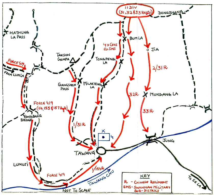
Map by Brig John Dalvi, 7 Infantry Brigade commander in October 1962
The Gorsam Chorten (Stupa) and the Namkha Chu are shown.


Wednesday, November 16, 2016

It pays to be tough with China

Tibet across the nalla (view from the Indian side)
My article It pays to be tough with China appeared in The Asian Age/Deccan Chronicle.

Here is the link...

The change in Chinese maps began with the objective to protect a new road linking Tibet to Xinjiang in Aksai Chin area in the mid-1950s.

Interesting news has been coming in from the high plateau of Ladakh. For three days, the Indian Army and the Indo-Tibetan Border Police had an eyeball-to-eyeball confrontation with the People’s Liberation Army on the Line of Actual Control in the border village of Demchok. While this village of Nyoma block in Leh district is small (with 74 inhabitants, the last census said), its location on the Indus river is strategic. It’s been a part of Ladakh and thus Indian territory for centuries. In fact, no Chinese was ever seen in this rather desolate area before the 1950s. Today, however, Beijing claims Demchok as Chinese. It’s not that China is Alzheimerish; it’s simply convenient to rewrite history for its strategic purpose. Before India’s independence nobody ever contested the fact that Demchok was the last village on the road to western Tibet on the Kailash Mansarovar pilgrimage. It was agreed to by all.
Take Rai Bahadur Dr Kanshi Ram, the British trade agent in western Tibet. Starting from Simla on May 20, 1937, he reached Srinagar seven days later; and from there was joined by Wazir Wazarat, commissioner of Ladakh, on his onward journey to the Tibetan border. Both officers were to meet the garpon (governor) of western Tibet for a tripartite inquiry into an alleged murder, in Ladakh a few years earlier, of a Tibetan, Champa Skaldan, by Zaildar, a Ladakhi of Rupchu. After a week’s halt in Leh, they reached Demchok on July 17, 1939, where they were to meet the senior and junior garpons; and the inquiry started three days later. Dr Kanshi Ram, in his report to Simla, notes: “On the night of July 21 the stream by the side of which we were camping suddenly rose to higher level and began to flow over our camping ground at midnight. We were abed as alarm was raised and we then got up and took our luggage and other belongings to a place of safety, and had to keep awake throughout the night. The rain, which began to pour down since morning, was still continuing. The next morning we crossed the stream and camped on the Tibetan border at a place of safety ... This stream forms a natural boundary between Tibet and Kashmir at Demchok.”
This is interesting because it shows that just before Independence the Indo-Tibet border in Ladakh was well defined and agreed upon by the government of British India (represented by the trade agent), the state of J&K (wazir) and the Tibetan government (garpons). Unfortunately, the Chinese “claims” have resulted in what is prosaically called today “differences of perception” on the Line of Actual Control. Why did China start claiming the area? The change in Chinese maps, particularly in the Demchok sector, began with the objective to protect a new road linking Tibet to Xinjiang in Aksai Chin area in the mid-1950s (the famous Aksai Chin road). Though the issue would only become public through a debate in the Lok Sabha in August 1959, in early 1950s New Delhi was already aware that China was building a road, but South Block was not ready to acknowledge it. Changing the map of the frontier was the best way for China to create a strategic buffer for the new road. But let us come back to the present stalemate.
In April, the residents of Demchok had appealed to the deputy commissioner in Leh for their resettlement elsewhere in the district; the reason was the continuous obstructions to development work in the area by Chinese troops. Quoting Army sources, scoops.news, a Ladakhi website, said last week that on November 2: “Nearly two platoons of the PLA came close to Indian territories in Demchok village and objected to laying of a water pipe for use in irrigation and drinking purpose, a project carried out by the state rural development department in the area.” The same source explained that the PLA personnel “appeared on the scene and raised objections to ongoing civilian construction work and stayed there for whole day and returned in late evening. Surprisingly, they appeared once again next day morning.”
The PLA asked local people to immediately stop their work; the Chinese quoted the agreement between India and China, which says either side needs prior permission before undertaking any construction work. This argument did not fool the Indian Army, who pointed out to the Chinese that the Indo-Sino border agreement specifically says information about the construction needs to be shared only in case the development was for defence purposes, not otherwise, certainly not for civilian work. While both sides continue to deny any incursions or transgressions, the Indian side clarified that issues, if any, would be resolved at a local level with Chinese officials at the border meeting point (Chushul in this case).
Finally, on the third day, local engineers could finish laying a water pipeline for irrigation of the remote Indian village. The pipeline is nearly a kilometre long. The stalemate ended on November 5 in the evening. The scene witnessed the holding of “vritual” banners by the PLA: “It is my territory, go back”; but the Army and ITBP personnel did not allow the PLA guards to erect a hut and the Chinese ultimately had to take the material back to their base camp in Tibet. In the end, the work was done: India didn’t back out while confronting the PLA troops in Demchok. Almost a few thousand kilometres away, also near the LAC, India took another great step to defend its borders. For the first time, the Indian Air Force successfully carried out a test landing and takeoff of the C-17 Globemaster-III at Mechuka’s Advanced Landing Ground.
After the upgradation of Mechuka’s ALG, the giant Boeing C-17 could land. It should eventually ensure the transport of men and material to the remote border village of west Siang district of Arunachal Pradesh, which was invaded by the Chinese in 1962. Let us not forget that Dibrugarh, the nearest air/rail head, is located some 500 km away (practically a drive of two days). A few days later, the eighth meeting of the China-India Defence and Security Consultation was held in New Delhi and Xinhua reported all was well at the border between India and China. Around the same time, Meng Jianzhu, China’s security tsar and member of the all-powerful politburo, discreetly visited New Delhi and met Prime Minister Narendra Modi (and home minister Rajnath Singh); apparently not about any border issues, but for a serious discussion on “global” terrorism. It always pays to take a tough position with China.

Tuesday, November 8, 2016

Some good news on the border front

C-17 lands in Menchuka
First the Indian Air Force successfully carried out a test landing and take-off of C-17 Globemaster-III at Mechuka’s Advanced Landing Ground (ALG).
A couple of years ago, I visited Mechuka which is strategically located in Arunachal Pradesh just 29 km from the border. (See The last village in 'our' Arunachal)
After the upgradation of Mechuka's ALG, the giant Boeing C-17 could land. It should eventually ensure transport of men and material in the remote border village of West Siang district of Arunachal, which was invaded by the Chinese in 1962.
Let us not forget that Dibrugarh the nearest air/rail head is located some 500 km away (practically 2 days drive).
India Today reported: “The aircraft was received by the Detachment Commander Fight Lieutenant S. Dixit on its maiden landing in Mechuka. The aircrew who, were part of this historic landing, included Group Capt TR Ravi, Wing Commander P Sisodia, Wing Commander AK Patnaik, MWO Tripathi and WO Nirana Ram. In the event of a disaster in the region, C-17 operations to the remote ALG can enhance the speed and quantum of national relief effort.”
This is a great step for the defence of the border in Arunachal and for the welfare of the local population.

The other good news
India did not back out when confronted to the People’s Liberation Army (PLA) is Demchok village in South-East Ladakh.
The national press reported that the Indo-Tibetan Border Police (ITBP) and the Indian Army were caught in an eyeball to eyeball situation with PLA on the Line of Actual Control (LAC) in Demchok.
As mentioned on this block, in April, the residents of Demchok had appealed to the Deputy Commissioner in Leh for their resettlement elsewhere in the district because of continuous obstructions to any developmental work in the area by the Chinese troops.
Quoting some Army sources, Scoops.news, a Ladakhi website says that “nearly two platoons of PLA came close to Indian territories in Demchok village and objected to laying of a water pipe for use irrigation and drinking purpose, a project being carried out by the state Rural Development Department (RDD) in the area.”
The same source explained: “Both sides have been holding their respective positions. On Wednesday [November 2], PLA personnel appeared on the scene and raised objection to ongoing civilian construction work and stayed there for whole day and returned in the late evening. Surprisingly, they appeared once again next day morning.”
The PLA asked the local people to immediately stopped the work; the Chinese quoted the agreement between India and China, which says that either side needs prior permission before undertaking any construction work.
This argument did not fool the Indian Army who pointed out to the Chinese that the Indo-Sino border agreement specifically says that information about the construction needs to be shared only in case the development was meant for defence purpose and not otherwise, particularly NOT for civilian works.
While both sides denied incursions or transgressions, the Indian side clarified that issues, if any, can be resolved at a local level with the Chinese officials at Border Meeting Point (Chushul in this case).
Meetings are regularly held to sort out of contentious issues between the two sides.
The interesting point is that despite the Chinese presence, the local population continued to work on the irrigation channels.

The work is completed
Finally on the third day, local engineers could finish laying a water pipeline for irrigation of the remote Indian village. The pipeline is nearly a kilometre long. The stalemate ended on November 5 in the evening.
India Today says that “the formula of 'active patrolling' adopted by the ITBP and the Army ever since 2013's fortnight-long stand-off near Daulat Beig Oldie [DBO] has been reaping rich dividends and Chinese have been cautious in carrying out incursion especially in Ladakh sector.”
The Army and the ITBP personnel did not allow the PLA guards to erect a hut and the Chinese ultimately had to take the material back to their base camp in Tibet.
The scene witnessed the holding of 'ritual' banners: “It is my territory, Go back”.
Construction was completed in the Indian side of the nalla
The fact remains that the work was done.

Some History
Historically Demchok has always belonged to Ladakh and has never been part of Tibet. I am quoting here from one on my articles on the subject.

On August 14, 1939, as he camped near Gartok, one of the three British (Indian) Trade Agencies in Tibet, Rai Bahadur Dr Kanshi Ram, the British Trade Agent (BTA) in Western Tibet, found finally time to write to the Political Agent of the Punjab Hill States in Simla: “I have the honour to submit herewith the following report of my journey from Simla to Gartok via Srinagar and Leh, Kashmir,” Ram started.
He had left Simla on May 20 to reach Srinagar on May 27; after a week-long stay in the Valley, he began his journey to the Tibetan border. He was accompanied by the Wazir Wazarat of Ladakh; both were to meet the Garpon or Governor of Western Tibet for a tripartite inquiry into the alleged murder of a Tibetan, Champa Skaldan by Zaildar, a Ladakhi of Rupchu. The crime had been committed in Ladakh a few years earlier.
After a week-halt in Leh, they started for Demchok, the last Ladakhi village before the Tibetan border. They reached Demchok on July 17, 1939, where they were to meet the Senior and Junior Garpons; the inquiry started three days later.
Dr Kanshi Ram, in his report to Simla, notes: “On the night of July 21 the stream by the side of which we were camping suddenly rose to higher level and began to flow over our camping ground at midnight. We were abed as alarm was raised and we then got up and took our luggage and other belongings to a place of safety, and had to keep awake throughout the night. The rain which began to pour down since morning was still continuing. The next morning we crossed the stream and camped on the Tibetan border at a place of safety. The Wazir also renewed his camp some yards away from the stream amongst the boulders. This stream forms a natural boundary between Tibet and Kashmir at Demchok.”
This is interesting because it shows that before Independence, the Indo-Tibet border in Ladakh was well defined and agreed upon by the government of British India (represented by the BTA), the State of J&K (the Wazir) and the Tibetan Government (the Garpons).
It is not true anymore; since the end of the 1950s, a very large area around Demchok is claimed by Beijing though no Chinese had ever been seen in the area. The fact is that soon after invading the Tibetan plateau, the Communist regime in Beijing started claiming more and more of India’s territory in the Himalaya.
Demchok is in fact a case study of Chinese ‘advances’ which resulted in what today is called a ‘difference of perceptions’ on the LAC.

The building of the Aksai Chin road
The Chinese ‘advances’ in the Demchok sector began with the objective to protect a new road linking Tibet to Xinjiang in the Aksai Chin area.
Though the issue would only become public through a debate in the Lok Sabha in August 1959, in the early 1950s already, Delhi was aware that China was building a road, but South Block was not ready to acknowledge it.
The Official Report of the 1962 War published by the MoD states: “The preliminary survey work on the planned Tibet-Sinkiang road having been completed by the mid-1950’s, China started constructing motorable road in summer 1955. The highway ran over 160 km across the Aksai Chin region of north-east Ladakh. It was completed in the second half of 1957. Arterial roads connecting the highway with Tibet were also laid. On 6 October 1957, the Sinkiang-Tibet road was formally opened with a ceremony in Gartok and twelve trucks on a trial run from Yarkand reached Gartok. In January 1958, the China News Agency reported that the Sinkiang-Tibet highway had been opened two months earlier and the road was being fully utilised.”
In his book The Saga of Ladakh, Maj Gen Jagjit Singh mentions that in 1956, the Indian Military Attaché in Beijing, Brig Mallik received information that China had started building a highway through Indian territory in the Aksai Chin area. Mallik had reported the matter to Army Headquarters in New Delhi which passed the report to South Block.
Other examples could be given, but the fact that the road lies close to Demchok, triggered the Chinese claims on the area.

Monday, December 16, 2013

Align for a good cause

My article Align for a good cause appeared yesterday in the Sunday Edition of The Pioneer.

Here is the link...
 
Non-Alignment was a senseless policy adopted by Jawaharlal Nehru, It has harmed the nation immensely, writes Claude Arpi
To many, ‘Non-Alignment’ was a senseless policy adopted by Jawaharlal Nehru soon after Independence. During the Cold War years, the country pretended not to side with any of the two blocks, though for practical purpose India was ‘aligned’ with the erstwhile Soviet Union, at least for its defence requirement and the manner of managing a planned economy.  Instead of pretending to be neutral, but betting on the Soviet support and then running to the US the minute it was attacked by China in 1962, India could have ‘aligned’ with both blocks.
In the book, Non-Alignment 2.0, edited by Shyam Saran, Sunil Khilnani et al, the authors admitted that some “commentators have questioned the wisdom of retaining a title that is allegedly outdated and associated in public perception with a failed foreign policy”. Non-Alignment is indeed outdated; the authors, however, believe that “the essence of Non-Alignment is India’s unwavering and continuing search for strategic autonomy”. Why mix strategic autonomy with non-alignment? General de Gaulle of France had an ‘autonomous’ foreign policy, while keeping France’s interests in view in his dealing with both blocks (and later China). The authors further explain that the famous principle: “Encompasses three core strategic principles that remain relevant to India’s engagement with the world: The need to make independent judgments in international affairs... the need to develop the capacity for autonomous strategic action to secure India’s own interests... and the need to work towards a more equitable international order.”
One can only agree with this perspective, but even if Shyam Saran and his colleagues distinguish between Non-Alignment and the fate of the Non-Aligned Movement, the choice of the title remains doubtful, being associated with too many blunders of independent India’s foreign policy.
Take the case of Tibet; though vociferous against colonial powers like Great Britain, France or The Netherlands, Nehru kept mum when Tibet was overtaken by a ruthless power. Why would India act ‘neutral’ in dealing with China, when its own ‘core’ interests were jeopardised? Sixty-three years later, one can still see the disastrous consequences on the Himalayan border (now a LAC). Non-Alignment has been too often synonymous with keeping India’s strategic interests under the carpet. This said, the publishing of Non-Alignment 2.0: A Foreign and Strategic Policy for India in the 21st century is a most welcome development; one can’t call it ‘an addition’, because very little work has been done this domain. Thus, it is all the more remarkable. The authors speak of “creating the space that India has all along sought to pursue its own destiny”.
Setting up the landmarks for India’s foreign policy, the collective work asserts: “Under no circumstances should India jeopardise its own domestic economic growth, its social inclusion and its political democracy.” Perhaps more than the words or the principles expounded in Non-Alignment 2.0, what is important is the fact that a group of Indians have seriously and meticulously thought of the future of the nation, taking a panoramic look at the past decades and tried to project India as a power to reckon with, into the 21st century. Such reflection has been rather missing in India, where the leadership (perhaps genetically) has not been used to project itself into tomorrow.
This is particularity striking when one compares India with China. The Emperors of the Middle Kingdom and their advisors have always been able to plan 10, 20 or 50 years ahead (even if in many cases, their dynasty did not last that long). It was obvious in 1962, when India was attacked by Mao’s troops and found unprepared, lacking even proper warm clothing for the slopes of the Thagla ridge or the cold plains of Ladakh. From the Chinese side, the attack had been prepared for years in the minutest details. Even today, India could (and should) learn from China on how to make projections into the future as the Chinese are undoubtedly better planners than the Indians. Take the building of infrastructure on the borders; more than 50 years after the debacle, India’s infrastructure is still rudimentary.
Already when he was heir-apparent, Xi Jinping stated: “We must implement Mao’s strategic concept of the ‘unity between soldiers and civilians’ and both the army and regional civilian authorities should assiduously pool our resources in the preparation for military struggle.” What does it mean? It signifies that the civil administration as well as the private sector should participate in the nation’s preparedness to defend its borders. Civilian infrastructure projects such as airports, roads and railways should be designed to serve both peace and war needs. South Block has never thought like this.
While I was recently visiting Menchuka, the last big village of West Siang district of Arunachal Pradesh, Beijing announced the opening of a highway linking Metok, located just north of the McMahon Line, with neighbouring Bomi town. Xinhua said that 117-km highway, costing $155 million will make the border town accessible for eight to nine months a year. Long ago, Beijing constructed a good quality Regional Highway S-306 in Nyingchi Prefecture. It runs parallel to the LAC (the McMahon Line) following the Yarlung Tsangpo river (known as Siang in Arunachal Pradesh and Brahmaputra in Assam). This road joins the 5,476 km National Highway G-318 which runs from Shanghai to Zhangmu on the China-Nepal border. That is planning and foresight.
Many points raised in Non-Alignment 2.0 hit the nail on the head; take this: “One of the great lessons of the late 20th century centred on the destabilising effects of asymmetries in power. The capacity of even small powers or non-state groups to generate effects disproportionate to their physical scale or their ostensible material power has become evident.” This basic truth should be taken into account for any policy planning.
One can only agree with the authors when they say: “China will, for the foreseeable future, remain a significant foreign policy and security challenge for India. It is the one major power which impinges directly on India’s geopolitical space.” They rightly suggest that India’s Tibet policy needs to be reassessed and readjusted and “persuading China to seek reconciliation with the Dalai Lama and the exiled Tibetan community may contribute to easing India-China tensions”. This type of projection, along with many other contained in the monograph, is what India needs the most today.

Wednesday, December 4, 2013

India should take a lesson from what China thinks and does

My article India should take a lesson from what China thinks and does is posted on Rediff.com

'There is still no road on the last 37 km between the McMahon Line and Menchuka in Arunachal Pradesh. Ironically, during my visit, Beijing announced the opening of a 117- km highway linking Metok, located just north of the McMahon Line.'
'My local friends kept saying with some envy in their voices, "The Chinese are very much in advance on us".' Claude Arpi on a recent visit to the last large village before the McMahon Line that divides India and China.
India should take a lesson from what China thinks and does, as there is no doubt that the Chinese are better planners than Indians.


Already when he was heir apparent, Xi Jinping stated: 'We must implement Mao's strategic concept of the 'unity between soldiers and civilians" and both the army and regional civilian authorities should assiduously pool our resources in the preparation for military struggle.'
What does it mean?
It signifies that the civil administration as well as the private sector should participate in the nation's preparedness to defend its borders.
Chairman Mao was an ardent advocate of 'The synthesis between the requirements of peacetime and war.' In other words, civilian infrastructure projects like airports, roads and railways should be designed to serve both peace and war needs.
It is not that Indians are unable to think far ahead. Sardar Patel had a far-sighted vision about Indian border issues.
On November 7, 1950 (just five weeks before he passed away), he wrote to Nehru on the following requirements:
  • A military and intelligence appreciation of the Chinese threat to India both on the frontier and internal security.
  • An appraisement of strength of our forces; A long-term consideration of our defense needs.
  • The political and administrative steps which we should take to strengthen our Northern and North-Eastern Frontier.
  • Improvement of our communication, road, rail, air and wireless in these areas and with the frontier outposts.
It is sad that nothing was done then, or later, on the issue of border development, even after the tragic events of October-November 1962...

To continue to read...

Sunday, November 10, 2013

The Last Frontier Post

Raining on Menchuka
In its section Agenda, The Sunday Pioneer publishes The Last Frontier Post, a report of my visit to Menchuka in West Siang.

Menchuka in Arunachal Pradesh remains one of the most unexplored regions in India. Claude Arpi tells about its people, its Sikh connection and, of course, its grievances

Explorers always loved the ‘blank’ on maps. It is perhaps the hallmark of the human spirit to want to know what it does not yet know. Even for modern Google Earth explorers like me, ‘blanks’ are fascinating. It is perhaps what encouraged me to visit Menchuka, the remotest, large village before the McMahon Line dividing India and China, in West Siang district of Arunachal Pradesh.
While researching for a book on the McMahon Line, I spent weeks exploring archival materials to understand this distant part of India, called the North East Frontier Agency (NEFA) by the British. I eventually found maps of most of the Frontier Divisions (Lohit, Siang, Subansiri and Kameng), but very little on the Siyom area. British explorers such as Capt Frederick Bailey and his colleague Capt Morshead surveyed the Himalayas ‘beyond the snow line’ (that is Tibet) to prepare the ground work for Sir Henry McMahon, the British Foreign Secretary, to draw his famed map, or later Francis Kingdon-Ward, the intrepid botanist and explorer who never visited the area or the nearby Manigong valley. It is strange because the passes from these two valleys are the easiest route to reach the Yarlung Tsangpo (which becomes the Siang after crossing the Indian border, and later the Brahmaputra in Assam).
The road from Arunachal Pradesh’s capital Itanagar, which passes via Assam, was uneventful, thanks to a customary Assam bandh which left the road free of its usual traffic; it is only after Likabhali, the ‘checkpoint’, that one re-enters Arunachal; after showing the authorities an Inner Line Permit (or Protected Area Permit for foreigners), that the adventure really starts.
Along (now written ‘Aalo’ by the local administration), the district headquarters, is located 130 km from the Assam-Arunachal border. During the six-hour journey, one starts experiencing the luxuriant vegetation. Suddenly, I understood better why the British preferred to keep the area ‘unadministrated’ between an Inner Line (the interstate border) and an Outer Line (the McMahon Line after 1914). It was simply too costly for the Empire to run a normal colonial administration on this terrain.
Only when circumstances forced them, the British ‘penetrated’ these impenetrable hills and imposed the Empire’s administrative system and ‘civilisation’ on the heterogeneous and often unruly tribes. The murder of Noel Williamson, the Assistant Political Officer at Sadiya, by an Abor tribe near Komsing village in East Siang district in 1911 was one such event. Meanwhile, one question had started bothering the British: Can China encroach in southern Tibet? This set the ball rolling and two years later the tripartite Simla Conference was convened which eventually resulted in fixing the India-Tibet border.
To reach Menchuka from Aalo takes an entire-day’s drive on the road poorly maintained by the Border Road Organisation, an Army outfit. But what a day! The road follows the turbulent Siyom river, cutting its way through deep canyons to the lowlands where it meets the Siang. The landscape is magical with dense forests, flocks of white clouds hanging over the deafening river and the imposing waterfalls; crossing small villages with a few large houses constructed of bamboo and local materials and built on high pillars, makes the trip even more picturesque.
The 180-km route to Menchuka is a treat in itself; during the nine-hour journey in a local Tata Sumo (the only car plying in the area), I never felt jaded for a minute. Having left Aalo early, I arrived in time in Menchuka (in Arunachal Pradesh the sun sets at 4.30 pm), to discover another world: A long plain with a large village built around the longest advanced landing ground of the State manned by the IAF, with houses looking like Icelandic cottages. As I was looking at the Menchuka plain surrounded by snow-peaks, my local hosts asked me: “Don’t you think it looks like Switzerland?” Perhaps, but it has a charm of its own.
Though this remote administrative Circle of West Siang is located just 50 km from the LAC (McMahon Line), Menchuka has been opened to tourism a couple of years ago and a few days after my visit, a Menchuka Tourism Festival was inaugurated by the Chief Minister.
There’s a controversy on what is the true name of the place — Menchuka or Menchuka? ‘Me’ means fire in Mempa, a Tibetan dialect; ‘Chu’ is water and ‘Ka’ is snow; as for Menchuka, it would mean the ‘land of the medicinal plant and river. Each visitor is left to decide the meaning.
Tourism could be a great boon for the local population which remains deprived of modern facilities such as newspapers, Internet or even a petrol pump. One of the most surprising attractions for the visitor is the cave where Guru Nanak once meditated. After driving some 15 km towards the Tibet border (close to the end of the motorable road), I reach a bridge where we have to leave our vehicle. After a steep climb of a few hundred meters, I arrived at a small dwelling built around the cave where the first Sikh Guru stayed, probably on his way to Tibet. A few years ago, I had seen another cave, north of Tawang, where a Nanak Lama would have done some tapasya; here too it was probably Guru Nanak. In Menchuka, the Guru left marks of his turban in the rock; you can even see his sandals. Walking down perilous slippery stairs made of planks, to reach the tumultuous Si river, I am told to fish for a stone in a small cavity on the river bed. To bring out a white stone is extremely auspicious and indicates that the blesings of the Guru are upon you. I am lucky to get one.
On the way back, I visit the old gompa (monastery). It is the oldest of the district and it belongs to the Nyingma tradition of Guru Padmasambhava. As the road to the Gompa is still under construction, to reach the top of the hill where the Gompa is perched is not an easy hike. But if you make it, the sight takes your breath away. The 360 degree panorama is most impressive. Not too far away is the snowline selected by McMahon and his Tibetan counterpart which today separates India and Tibet. I marvelled at the Si river meandering tumultuously in the valley; it will become the Siyom after joining the Yomi in Tato village, 50 km downstream.
One historical aspect of Menchuka is always present: China occupied the area for a few weeks in November 1962. Some old people still remember the Chinese ‘visit’. I was told: “The Chinese soldiers were not aggressive; they just told us: ‘you are Chinese like us, we will never harm you; you don’t have long noses like the Indians, your eyes and skins are similar to ours’.” Today Beijing still calls the area ‘Southern Tibet’.
One general regret in Arunachal Pradesh in general and Menchuka in particular is that the Union Government has done very little to develop the road network during the past 50 years. The road in the last 37 km between Menchuka and the border is still not motorable; the situation is worse in the neighbouring Manigong valley.
One litany I heard during my stay in Menchuka is, “Why don’t we have proper roads to the border? Why can’t Delhi reopen the border like it did for Nathu-la in Sikkim?” I have no answers. Ironically, the Chinese recently announced the opening of a highway linking Metok with neighboring Bomi town, located not far away north of the McMahon Line.
On the last day of my stay, I meet ‘the oldest man’ of the area; he is 101 years old. He was already a gaon burah (village headman) when the Chinese came in 1962. When I ask him about his most cherished dream, he says: “Tell the Prime Minister to reopen the border, I want to visit my relatives in Tibet and bring back yaks; the species has become extinct on this side of the border.” Is the Prime Minister listening?

Thursday, November 7, 2013

Roads connect people and stave off mischief

My article Roads connect people and stave off mischief appeared today in the Edit Page of The Pioneer

Click to read...

If after opening Nathu-la, thousands benefit from tourism in Sikkim, why should a similar strategy not be there for Arunachal Pradesh? If New Delhi doesn’t want to repeat 1962, it must win over the local population

For many years, I had dreamt of visiting Menchuka, one the remotest places on the way to the McMahon Line dividing India and China, in West Siang district of Arunachal Pradesh. What fascinated me was the fact that British explorers such as Captain Frederick Bailey and his colleague Captain Morshead, who in 1913 surveyed the Himalayas to help Henry McMahon, the British Foreign Secretary, draw his famed map, had never visited the area. It remained a ‘blank’ on the maps. Last month, I finally made it to Menchuka.
After leaving Along, the West Siang district headquarters located 130km from the Assam-Arunachal border, it took another nine hours to reach West Siang’s northern-most administrative circle. A short journey, compared to the perilous adventures of the then Assistant Political Officers travelling from Pasighat in Assam on the annual tour of the North-East Frontier Agency. Expeditions, Missions or simple ‘Promenades’, as the British called them, used to explore these ‘unadministrated’ areas, south of the Outer Line (known as the McMahon Line after 1914).
Today, things have changed. To reach Menchuka from Aalo, takes ‘only’ an entire-day’s drive on the road poorly maintained by the Border Road Organisation; Menchuka is still some 50km away from the Line of Actual Control. Though the Army has apparently started working on a motorable road, my local guide told me that the last 37km to reach the border still have to be walked.
It was ironical, but on the day I reached Menchuka, China announced, mostly ignored by the Indian media, one of the most important strategic advances of the decade. On October 31, Xinhua reported: “Highway open to traffic for China’s last roadless county”. It asserted: “A highway linking Medog [or Metok for the Tibetans], the last roadless county in China, with neighboring Bome county in Tibet formally opened to traffic, ending the county’s isolation from the outside world.” Where does that road lead to?
Not only does it reach within a few kilometers of the Indian border (McMahon Line), north of the Upper Siang district of Arunachal Pradesh, but it opens the way to construct a series of new dams on the Yarlung Tsangpo (which becomes the Siang as it enters India and later the Brahmaputra in Assam). Xinhua announced: “The 117km highway, which cost 155 million US dollars, links Zhamog Township, the county seat of Bome, and Medog in Nyingchi Prefecture in south-eastern Tibet. The road will be accessible for eight to nine months per year.”
It is one of the most pristine regions of Tibet. The Tibetans have always considered the area around the Bend of the Yarlung Tsangpo as the home of the Goddess Dorjee Pagmo, Tibet’s Protecting Deity. Many believe that this place, locally known as Pemakoe, is the sacred realm often referred to in their scriptures: The last hidden Shangrila.
The difficulty of access to the region was one of the greatest obstacles for the engineers who worked in Beijing on the hydro-power plants on the river. For them, it was enough to know that the Yarlung Tsangpo river tumbles down over 3,000m in less than 200km, giving the gorge one of the greatest hydro-power potentials available in the world. It made the new emperors in Beijing dream.
For India, the road’s closeness to the McMahon Line cannot be ignored. Xinhua says: “Mountain paths connecting villages and towns were once the only travel routes in Medog, situated near Tibet’s border with India… complicated geological conditions and frequent natural disasters had thwarted seven previous attempts to build a highway in the area.” The building of the new road was approved by the State Council, China’s Cabinet in 2008 and work officially began in April 2009.
A local Tibetan told the Chinese news agency: “Foot travel and horses have long been the only transportation method for goods in Metok, which has a population of 12,000,” adding that before the opening of the road, “a can of beer [used to be] sold for 10 yuan, more than twice the price of a can in Lhasa”. It makes the populations on our side of the border dream too: Only five years to open a road in such difficult terrain, with one of the longest tunnels in Tibet!
In Menchuka, one hears only regrets. But the situation is even worse in the neighbouring Manigong valley: From Tato, a subdivision headquarters where the Si and the Yomi rivers join to form the tumultuous Siyom, it takes seven or eight hours to cover the 67km to reach Manigong. And then, no road.
One remembers that in August former BJP MP Tapir Gao had claimed that the People’s Liberation Army had intruded at least 30-40km into Indian territory after over-running at least six of the nine Indian check posts in Chaglagam sector of Anjaw’s district. In such a case, it is the local populations which suffer the most, though the Chinese usually treat the indigenous tribes well; they tell them: “You are our own people”, in other words, “Chinese”. Does not China still call the entire State of Arunachal, ‘Southern Tibet’?
Let us not forget that Menchuka and Manigong sub-sectors of Siang Frontier Division witnessed heavy fighting in 1962 and the PLA, who entered via both valleys and regrouped after trekking over local trails, managed to reach Yarpik, some 80km beyond Menchuka. They stayed for three weeks and cajoled the local Adi and Mempa tribes and said, “We will never harm you; we have only a problem with the Indians, you don’t have long noses like them, your eyes and skins are similar to ours”. The people were not fooled, but they could not do much against the Mao's Army which quickly outnumbered the Gorkha Rifles manning the Menchuka-Manigong sector.
One day, I had the good luck to meet 'the oldest man' of the area; he is now 101 years old; he was already a gaon burah (village headman) in 1962. When I asked him his most cherished dream, he said: “Please, tell the Prime Minister to reopen the border, I want to visit my relatives in Tibet and bring back yaks; the species has become extinct here.”
A litany that I heard during my stay in Menchuka is, “on the other side, they are much in advance on us. Why don’t we have proper roads to the border?” It would certainly be a workable solution to ‘fix’ the border and develop the area; Delhi definitively needs to take the local population along.
If after opening Nathu-la, thousands live from the tourism in Sikkim, why not the same in Arunachal? If Delhi does not want to repeat 1962, roads are strategically and militarily vital, but as important, India has no choice but take the local population on its side.

Tuesday, November 5, 2013

Sardar Patel had vision to address needs of border States

Tibet seen from Menchuka
My artcile Sardar Patel had vision to address needs of border States appeared in NitiCentral.

Here is the link...

It was raining and cold outside. I was sitting with my local hosts around a smokeless chula installed in the center of the main room of their house.
I was in Menchuka, the remotest large village before the McMahon Line dividing India and China, in West Siang district of Arunachal Pradesh.
After watching some cricket match between India and Australia (I don’t understand anything of cricket), my hosts from the Adi community (one of the 25 main tribes of Arunachal Pradesh) switched their satellite TV to a news channel.
The Indian Prime Minister was seen with the Chief Minister of Gujarat inaugurating a large statue of Sardar Vallabhbhai Patel. When I asked if they were following Indian politics, my friends replied, ‘of course! We Arunachalis are the most patriotic people of the country, though the leadership in Delhi seems ignorant about this simple truth’. It is true that a few minutes earlier, they had been frantically supporting the Blue Team against the Aussies.
They were now amazed by the size of the statue and kept repeating, “We need a strong leader to rule India”. Though not particularly enamoured of the BJP, they believed Narendra Modi could be the ‘next Iron Man’ to protect them.
When I asked why they thought so, they said only an ‘Iron Man’ could bring roads and development to the border areas.
Menchuka, located some 50 km from the LAC (McMahon Line) witnessed the ‘visit’ of the Chinese 51 years ago; some old people still remember their stay for nearly one month in November 1962. I was told: “the Chinese soldiers were not aggressive; they just told us: ‘You are Chinese like us, we will never harm you; you don’t have long noses like the Indians, your eyes and skins are similar to ours’”; today Beijing still calls the area ‘Southern Tibet’.
It is a fact that while in Menchuka, the PLA did not take food or disturbs the local tribal Adis or Membas; despite this, the local population has remained loyal to India; unfortunately Delhi does not often acknowledge this.
The declaration of Narendra Modi: "Every Indian regrets Sardar Patel did not become the first Prime Minister. Had he been the first Prime Minister, the country's fate and face would have been completely different," rang true in this remote administrative Circle of Arunachal Pradesh (it takes 9 hours by car to reach Menchuka from Along, the district headquarters).
Warming up around the chula, the famous letter sent Sardar to Jawaharlal Nehru, five weeks before the Deputy Prime Minister prematurely passed away, was constantly present in my mind.
For the people of the border areas, it would have indeed been different if Gandhi had not interfered in the democratic process (Patel had been elected to lead the Interim Government in 1946, but Gandhi preferred ‘the Haddows Boy’) and if Patel had become Prime Minister.
On November 7, 1950, a month after Tibet was invaded, Patel told Nehru: “I have tried to peruse this correspondence [between K.M. Panikkar and the Communist government in Beijing] as favorably to our Ambassador and the Chinese Government as possible, but I regret to say that neither of them comes out well as a result of this study.”
The ‘Iron Man’ added: “The Chinese Government has tried to delude us by professions of peaceful intention. My own feeling is that at a crucial period they manage to instill into our Ambassador a false sense of confidence in their so called desire to settle the Tibetan problem by peaceful means. …the action of the Chinese, in my judgment, is little short of perfidy.”
Patel’s conclusion was: “from the latest position, it appears that we shall be not be able to rescue the Dalai Lama.” It was already too late.
Panikkar was not only “at great pain to find an explanation or justification for Chinese policy and actions”, but Nehru did not even have the courtesy to acknowledge Patel’s letter which suggested to review:
•  A Military and Intelligence appreciation of the Chinese threat to India both on the frontier and internal security.
•  An examination of military position and such redisposition of our forces as might be necessary…
•  An appraisement of strength of our forces …A long-term consideration of our defense needs.
•  The question of Chinese entry into UNO.
•  The political and administrative steps which we should take to strengthen our Northern and North-Eastern frontier.
•  Improvement of our communication, road, rail, air and wireless in these areas and with the frontier outposts.
It is tragic that 63 years later, there is still no road for the last 37 km between the McMahon Line and Menchuka (though I was told the construction may start soon). The situation is much worse in the adjoining sub-division of Menigong. From Tato, another sub-divisional headquarters to Menigong, it takes some 7/8 hours to cover 67 km, and then, there is no road going onward to the border.
Ironically, during my visit to Menchuka, the Chinese announced the opening of a highway linking Metok, ‘the last roadless county in China’ with neighboring Bomi town, located just north of the McMahon Line.
The Communist Party said that 117-km highway, costing 155 million U.S. dollars will make the border town accessible for 8 to 9 months a year.
My local friends kept repeating with some envy in their voices, ‘the Chinese are very much in advance on us’.
To come back to Patel's 'clairvoyant testament', it is not well-known that it was based on a Note prepared by Girja Shankar Bajpai, the Secretary General of the Ministry of External Affairs.
Does this Note still exist? I was recently told that some of the Bajpai Papers may have followed the fate of the CoalGate files.
Why did Nehru, then Foreign Minister not act on his Foreign Secretary's Report while it was Patel who was concerned by the issue of having an "unscrupulous, unreliable and determined power at the doors"?
It is not difficult to answer this question. Nehru saw China as India’s best friend, if not brother.
Another reason why Patel would have made a difference is that he would have surrounded himself with efficient down-to-earth officers like Bajpai and not glamourous, worthless collaborators like K.M. Panikkar.
A few years later, Bajpai compared the protests of Panikkar with Neville Chamberlain's disapproval of Nazi Germany entering Czechoslovakia in 1938, he said: "Our Ambassador has allowed himself to be influenced more by the Chinese point of view, the Chinese claims, the Chinese maps and by regards for Chinese susceptibilities than by his instructions or by India's interests.”
Nehru did it again in 1962 when he listened to an arrogant Corps Commander, ignoring the Army hierarchy’s sounder counsels.
It is not enough to be a strong man; a leader of worth should be able to surround himself with wise advisors. Patel showed, at the time of the integration of the Indian States (with V.P. Menon) or later in the case of Tibet (with G.S. Bajpai), that he was more than an Iron Man, he was also ble to find and listen to knowledgeable collaborators.
A small post-scriptum: Patel would have also made a difference in the Kashmir issue. On 23 December 1947, as Deputy Prime Minister, Patel wrote a draft letter to Nehru: “Your letter of today has been received just now at 7 p.m. and I am writing immediately to tell you this. It has caused me considerable pain.” Patel did want India to appeal to the UN: “your letter makes it clear to me that I must not, or at least cannot continue as a Member of Government and hence I am hereby tendering my resignation.”
Gandhi asked Patel to withdraw his resignation. The rest is painful history.
It is unfortunate for India that history cannot be rewritten. But one can at least learn from history.