|
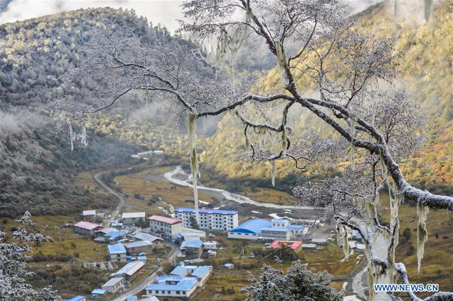
| Tsona village, north of Tawang district |
A quick review at the Chinese press related to Tibet during the last few weeks shows an extremely worrying trend for India.
While the Indian media has been concentrating on Doklam, the happenings on the other side of the border, especially north of Arunachal Pradesh are disturbing.
A few weeks ago, an article in
The Tibet Daily mentioned these new developments: “Making the border villages prosperous and well-off is the top priority of the poverty alleviation campaign."
China's second objective is to build-up the border defenses.
It says that some 628 border villages needed to be turned into prosperous and well off administrative villages.
But let us go through some of the articles/comments.
Border Representation at the National people’s Congress
During the recently-concluded National People's Congress (NPC), Phurbu Dhondup, a deputy and Governor of Lhoka, said there were 96 such border villages in Lhoka Prefecture alone.
He asserted that the provinces of Hunan, Hubei and Anhui would help Lhoka “make the dramatic transition" from poor border villages to prosperous ones with electricity, first rate access roads, irrigation systems and potable water.
The participation of the 'rich' provinces of China in the scheme is to be noted.
As earlier mentioned in this blog, Drokar (alias Choekar) has been in the news.
Other delegates from the borders with India are:
- Tashi Gyaltsen, a 29 year old Lhoba who worked in building village organization
- Mi-ma Guo-ji, (his Tibetan name is not clear), a young man who builds electricity transmission lines to villages.
- Kesang Dikyi who comes from Metok, north of Tuting sector of Arunachal, which recently witnessed a border intrusion (with Chinese excavators). She is a primary school teacher in a village near Metok.
As mentioned earlier, Kelsang Dekyi was born in 1978, symbolically the beginning of an era which saw the Chinese people “relying on knowledge to change its destiny;” she grew up in Metok County “once a remote, poverty-stricken, and information-poor area.”
Kelsang Dekyi told a press conference in Beijing: “Our school building was very poor; teachers and students had to pick grass to cover the roof. The grass was taller than we were, so when we were walking back we'd often trip, and we often had our hands cut. However, if we didn't pick the grass, we couldn't cover the roof, and rainwater would leak into the classroom."
The CPPCC’s TAR delegation has a member from the border area, a Loba lady
from Tsari village, east of Yume.
Let us remember that the Tsari chu (river) enters India south of Migyitun which saw the first border incident between India and China in August 1959 (Longju).
The lady cadre is called by what seems a Chinese
name, Gong-jue Qu-zhen.
 All townships in Tibet to be reached
On March 4, Xinhua announces
‘Highways to reach all townships in Tibet by 2020’.
The article says: “Tibet will strive to make highways reach all townships and administrative villages by 2020 in a bid to boost rural development. …By 2020, all townships which meet necessary conditions and 80 percent of administrative villages would have access to bus service.”
This includes the border villages, north of Arunachal, Sikkim, Uttarakhand and Ladakh.
According to a senior transport official of the Tibet Autonomous Region (TAR), “road construction will help the region reduce poverty and increase the income of farmers and herders, according to the official.”
In 2018, the region will launch projects to make 13 townships and more than 1,000 villages connected by asphalt or cement roads. Rural road mileage in Tibet is currently 60,421 km, compared with 53,244 km in 2012.
In other words, 'an integrated transportation system'.
The Dual Mission
The objective is dual, poverty alleviation and ‘protection' of the border.
When the People’s Liberation Army (PLA) entered Lhasa in September 1951, General Zhang Jingwu, the representative of the CPC’s Central Committee told Sumul Sinha, the head of the Indian Mission in Lhasa that the Chinese had come to Tibet for two reasons only (he spoke of ‘a dual mission’): to eliminate all imperialist influences and to improve the standard of living of the Tibetans.
Of course, there was no ‘imperialist influence’ on the Roof of the World, but poverty was there.
What is surprising is that, 66 years later, the Chinese government still speaks about fighting poverty on the Tibetan plateau.
It means a colossal failure for the Communist State.
The new Helmsman wants to rectify this.
An article in
China Tibet Online recently noted: “Through the establishment of archives, and accurate identification of those requiring help, the number of poverty-stricken people has reduced by more than 500,000 in the last four years. The TAR's Poverty Alleviation Office has gradually established a targeted poverty alleviation system, whereby the causes of poverty are analyzed and the limited special funds are used on the poor people.”
Apart from the Targeted Poverty Alleviation, the article speaks of Industry Poverty Alleviation, Education Poverty Alleviation, Tourism Poverty Alleviation, Health Poverty Alleviation, while asserting: “Tibet explores the practice of ‘the rich helping the poorer to wealth’, and uses the capable people as one of the main driving forces of poverty alleviation.”
One Tsering, deputy director of the Lhasa Poverty Alleviation Office, told the website: "these capable people have experience, skills and the mind, and also have the ability to help the poor escape poverty. With some help they are running a series of projects, which can provide the poor families with an income salary as well as a bonus and other secure incomes. The results are clear to see.”
For Beijing, tourism is perhaps the best way to alleviate poverty ...and to protect the border (by buying the local population on China's side).
And provinces have been called to the rescue to 'invest'.
It is worrying, because there is no doubt that each investor will want a 'return'. What does it mean for Tibet is difficult to predict.
Infrastructure development
On March 23,
VTIBET.com writes
‘Tibet builds integrated transportation system.'
The website publishes a photo of the new roads, taken near Gongkar Lhasa Airport with the caption “expressway from Lhasa to Zedang (Tsetang in Tibetan) Township of Lhoka City.”
The article says: “In the past five years, China has been increasing the investment in infrastructure construction in Tibet Autonomous Region. An integrated transportation system based on highway, railway, aviation and pipeline has been built up to now, which provided a strong support for the economic development and prolonged stability of Tibet Autonomous Region.”
The repetition of the word ‘stability’ while speaking of the region, probably means that presently the TAR is not too ‘stable’.
How to stabilize Tibet?
By bringing millions of tourists who will bring good revenue to the local population.
How to stabilize the borders?
By bringing millions of tourists to the borders and develop the border villages
Another site
en.tibetol.cn mentions the
'New highway to link Chamdo with Tibet’s highest-altitude airport.'
It says that the construction of the Chamdo-Bamda Airport section of the National Highway 214, linking Tibet's highest-altitude airport at an elevation of 4,334 meters to Chamdo city has started. It will greatly help to develop tourism in Eastern Tibet.
The article asserts that the distance of 120 kilometers can be presently covered in two hours; once the new highway is completed, it will take just one hour: “The highway will also facilitate communication between east Tibet and the outside.”
Some technical details are given: “The first phase is to be completed within 24 months. 21 mega bridges, 11 medium bridges, 2 tunnels and 11 cross-river bridges will be built along the 26.9 kilometers highway with a design speed of 80km/h. Tibet has already opened seven high-level roads including the Lhasa-Nyingchi road, with a total length of 660 kilometers.”
Another site,
China Tibet Online notes that
'Tibet on fast track to facilitate travelers'.
According to Wang Songping, head of the Tourism Development Committee of Tibet: “The increasingly improved transportation infrastructure has allowed travelers to spend less time on road as they tour in Tibet.
Wang said that highways, railways and airports have improved continuously to facilitate travelers' trips and meet their need to move fast on their way to scenic spots.
With most part of the Lhasa-Nyingchi Highway opened to traffic, “it will be more convenient for travelers to pay a visit to Nyingchi,” noted Wang.
All this infrastructure being built for 'dual use' (civil and military), means that ultimately, it will bring more pressure on the Indian border.
Extended tourist season
The season has been extended and winter is promoted as the best season to visit the Roof of the World.
Photos appeared on one website showing the scenery in Lhasa: “the Potala Palace is extremely beautiful after the strongest snowfall since last year's winter arrives in Lhasa, capital city of southwest China's Tibet.”
Note the Land of Snows, is always called ‘China’s Tibet’.
Would we write in India, ‘India’s Tamil Nadu or India’s Arunachal’?
No.
Does it mean that China is not sure if Tibet is China's?
Beijing seems to have a serious problem here.
Other pictures show a Park in Lhasa, capital of China's Tibet, “after the strongest snowfall since last year's winter arrives in the evening of March 17, 2018;” another illustration pictures a child is playing in the snow.
Developing the Indian Borders
I often wrote about Yume, the hamlet north of the McMahon (Upper Subansiri district of Arunachal Pradesh).
In October 2017, Chairman Xi Jinping had written a letter to two young Tibetan herders who had introduced their village to the Chinese President.
A letter from the Emperor always shows the trend in the Kingdom.
 |
| Yume village |
The Global Times recently reported: "A sparsely populated township in Southwest China's Tibet Autonomous Region has been connected to the state electricity grid, ending life without electricity for its 32 residents."
The village is Yume.
The Global Times' article quotes the contractor, a Xining-based electric power company who worked on the project: "The 15-kilometer 10-kilovolt power line, which took five months to complete, is connected to remote Yulmed [Yume] Township in Luntse [Luntse] county, Shannan [Lhoka], via 108 electric poles over a 5,000-meter-high mountain."
According to the tabloid, Yume (also spelt Yulmed) is located "at an average elevation of 3,650 meters above sea level and its population was once just a three-member household. Currently, it has nine households."
It is further explained that in 2008, the local government built a small hydropower station, but the project failed to meet the increasing power demands of the 32 residents: "Due to improved living standards and growing need for electricity of the residents, power outages were frequent."
But that is not all.
Uplifting the border villages
The China Daily recently announced: "Investment in infrastructure in the Tibet Autonomous Region is helping to lift 628 villages along the border out of poverty." It further asserted: "After getting access to electricity and the construction of new roads, tea farmers and herdsmen in a village some 200 kilometers southwest of Lhasa in Tsona county founded a cooperative that provides skills training and job opportunities for villagers."
Tsona is located north of Tawang district of Arunachal.
The area has been extensively developed.
In November 2016, I wrote
The Chinese tourists arrive on the Indian border. It was about the village between Tsona and the Indian border.
Now China admits: "Starting last year, more than 100 million yuan (15,263 million US dollars) has been invested in infrastructure in the village of less than 100 families as a part of a broader construction project to build model villages with moderate prosperity in the border area. The construction of well-off villages along the border is designed to advance the living and working conditions in surrounding villages."
The China Daily estimated that the road access rate in the area will reach 100 percent and the per capita disposable income will double by the year of 2020.
 |
| Dances in Tsona |
Tsona again in the news
On March 23,
China Tibet News reports, “Tibet’s border villages speed up development of rural tourism.”
The short article is accompanied by a photo showing “the beautiful border village in Tsona: “the construction of Tibet's border moderately prosperous villages, tourism in border villages develops rapidly. Tsona County, Shannan City of southwest China's Tibet Autonomous Region, makes great efforts to boost rural tourism, which also increases the income of local villagers.”
Again in China’s TAR!
Tsona is also been linked with Tsangyang Gyaltso, the Sixth Dalai Lama born in Urgyeling, near Tawang. He would have stayed in Tsona on his way to Lhasa to be enthroned. Every year, a Tsangyang Gyaltso Festival is being organized by the Communist authorities, who, when it is convenient, promote the Dalai Lamas.
Chumbi Valley
 |
| Danses in Yatung (Dromo) |
On February 28,
VTIBET.com mentions that “Dromo County held sending culture and art to villagers activities”.
Though the title is not very clear, Dromo is the Tibetan name for the Chumbi Valley, east of Sikkim.
Probably due the vicinity of Dolkam, the activities were not only ‘cultural’, a photo showed officers from People’s Court of Dromo County handing out ‘basic legal knowledge’ leaflets to villagers.
What were these ‘legal leaflets’ about is not clear?
That the entire Chumbi Valley belongs to China?
Other illustrations shows Dromo County’s folk art troupe “performing wonderful song and dance programs.”
Nothing has been published in the railway line to Yatung in Chumbi Valley recently.
China is keeping quiet about it, since the Doklam episode.
Ngari, Western Tibet
According to
VTIBET.com, the prefecture of Ngari received over 660,000 visitors in 2017
The website says: "Ngari, an ancient prefecture located in West Tibet, received a total of more than 660,000 domestic and overseas visitors last year, with a year-on-year growth of 20 percent. The tourism revenue totaled about 750 million yuan, up by 10 percent over the same period last year.”
Ngari Tourism Bureau affirms “Hailed as ‘Roof of the Roof of the World’, Ngari, at an average elevation of 4,500 meters above, is the birthplace of the four major rivers in Asia. It’s the place where the Himalayas, the Gangdise, the Kunlun Mountains and Karakorum Mountains meet. …There are great mountains, beautiful lakes, vast grasslands and spectacular snow mountains in Ngari. Famous tourist landscapes, including Mapam Yumtso [Manasarovar], Kangrinpoche [Kailash], Guge Kingdom Relics [Tsaparang, Tholing], Piyang-Donggar Caves Relics, Zanda Clay Forest.”
According to Liu Qilin, deputy director of Ngari Tourism Development and Reform Commission: “In 2017, more than 12,000 farmers and herdsmen in Ngari participated in tourism industry, creating income of 153 million yuan, and promoting tourism development of 11 poor villages with tourism development conditions.”
Further, it is said that 12 new tourism projects were built in Ngari last year, with a total investment of about 11,62 million yuan, and a total of 96.6 million yuan budget was approved by the central government to invest 6 key tourism projects that were declared to the 13th Five-Year Plan.
The Pangong Lake
 |
| Pangong tso from the Indian side |
The report also mentioned Pangong tso (lake), “inscribed in 50 awe-inspiring natural wonders by CNN.”
Part of the lake is in eastern Ladakh, part in Ngari: “This beautiful lake sits at an elevation of 4,350 meters. The lake and sky are both amazing shades of blue that make it become one of the must see scenes.”
The quick development of tourism in Western Tibet is bound to bring more pressure on the Indian border in Uttarakhand and Ladakh.
And this without mentioning, “the smooth progress towards the world's highest altitude gravitational wave telescopes in Tibet Autonomous Region to detect the faintest echoes resonating from the universe, a project insider disclosed.”
During the CPPCC’s 13th National Committee, Zhang Xinmin, chief scientist of the project said that the main part for the first stage of the ‘Ngari plan’, which was launched by China in March 2017 to eyeball the Big Bang cosmic waves at Ngari, is almost completed,
Zhang, a senior researcher at the Institute of High Energy Physics in the Chinese Academy of Sciences (CAS) observed that the project will start operations in 2020 and observation results will be available in 2022.
More tourists in view.
Tibet to limit visitors for 'high quality' tourism
On March 22, according to
The Global Times, China's Tibet “vows to control the number of visitors in the region's scenic spots, including Mount Chomolangma, known as Mount Everest in the West.
This is what Qi Zhala (or Che Dralha), chairman of the TAR and a deputy to the 13th National People's Congress, told the China National Radio (CNR)
Tibet will develop ‘high quality’ tourism: “The number of tourists will be strictly restricted at some scenic spots. We introduced a cap of 5,000 visitors for the Patala [Potala] Palace in summer, and we will strictly control the number of tourists to Mount Chomolangma."
Che also admitted that “Tourism is the main channel for the opening-up of the region's economic development and the main force to improve residents' lives,” he added that “developing tourism must stick to the bottom line of environmental protection.”
With the winter tourism promotion scheme offers free admission to 115 major tourist attractions in the region, including the Potala Palace, from February 1 to April 30, plus discounted fares for hotels, local transport, flights and train services.
Some conclusions
In Tibet, China is pursuing a dual policy to tackle ‘poverty alleviation’ and ‘protect' its borders (with India).
Tourism is used in the grand scale to achieve these two objectives.
The support of the ‘rich’ provinces of China is also asked for.
To develop the borders means to ‘stabilize’ the borders.
By 'stabilizing' the border areas, Beijing protects its borders.
Extensive ‘dual use’ (civil and military) infrastructure is built for the purpose.
This creates a worrying scenario for India.